
Photo: Wikipedia
Strategic Assessment of Statesville, NC
Meaningful friction. Expect exposure to either population pressure, blast zones, or natural disaster risk. Consider buying a retreat property.
What does the Strategic Assessment tell us?
Our Strategic Assessment grades tactical survivability of an area. Major population centers, military targets, fallout zones, natural disasters, and border exposure all drive risk — lower exposure means a more defensible position in a crisis.
This is heavily inspired by Joel Skousen's Strategic Relocation book. Highly recommended you checkout the book ($)What does this tell us?
Our Strategic Assessment grades tactical survivability of an area. Major population centers, military targets, fallout zones, natural disasters, and border exposure all drive risk — lower exposure means a more defensible position in a crisis.
This is heavily inspired by Joel Skousen's Strategic Relocation book. Highly recommended you checkout the book ($)Strategic Pillars

Key Distances
Regional Safe Places
Below is our recommended "safe zones" in North Carolina and the surrounding area based on our strategic heuristics. For most people, it's unrealistic to live in a “safe zone” full-time due to work, family or other personal reasons. They tend to be more rural. However, many of these areas are perfect for second homes and retreat properties that double as a vacation home or even a short-term rental.


Important Note: For informational purposes only. This does not mean nothing bad ever happens in the green zones. Please use common sense. This is based on public data and modeled with AI. We tried to take a conservative approach but mistakes happen. We update this regularly as new information becomes available.
Solar Generator Recommendations
Backup power matters more here than in safer locations. We've picked three solar generators across budgets and capacity tiers — start with the budget unit if you only need a few essentials, or step up if you want to run a fridge and HVAC for days at a time.

Jackery Portable Power Station Explorer 300
Budget OptionPower on the Go: Weighing only 11 lbs, it's convenient to set up and store with book-sized foldable solar panels

BLUETTI Portable Power Station AC180
Designed for both indoor and outdoor scenarios, AC180 is highly capable as it has a robost capacity and continuous output power.

EF ECOFLOW DELTA Pro Ultra Power Station
Upgraded PickEcoFlow DELTA Pro Ultra is a whole-home energy system designed to grow with your family. Integrated with the Smart Home Panel 2, it scales to meet your evolving energy needs — keeping your home powered, intelligent, and secure through every stage of life.
We earn a commission, at no additional cost to you.
Strategic Assessment Analysis
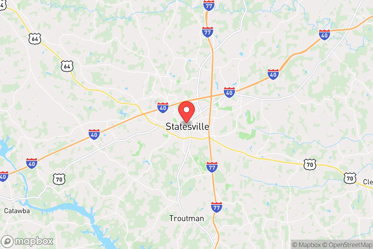
Statesville, North Carolina, offers a surprisingly resilient strategic position for those prioritizing preparedness, sitting at the crossroads of I-40 and I-77 roughly 40 miles north of Charlotte. This location provides a critical buffer—close enough to access major medical and supply networks, yet far enough to avoid the immediate fallout of urban unrest or a major disaster in a metropolitan area. The city's historic role as a rail and logistics hub, combined with its position in the Piedmont region away from the immediate hurricane-prone coast, makes it a viable base for long-term sustainability. For the conservative prepper, Statesville represents a middle-ground option: not a remote bunker, but a defensible, resource-rich staging area with a strong community fabric that hasn't yet been eroded by the chaos of larger cities.
Geographic position and natural advantages for long-term sustainability
Statesville sits in Iredell County, a region defined by rolling hills, hardwood forests, and the Catawba River watershed, which provides a reliable freshwater source. The area's elevation, roughly 900 feet above sea level, offers a natural defense against the worst of hurricane storm surges and flooding that plague coastal regions, while the clay-based soil supports small-scale agriculture and gardening. The proximity to the Brushy Mountains and the Uwharrie National Forest, both within an hour's drive, provides additional options for retreat, foraging, and off-grid living if needed. The climate is temperate—four distinct seasons with mild winters and moderate summers—reducing the risk of extreme weather events that could cripple infrastructure. For a relocator, this means a lower likelihood of catastrophic crop failure or freeze-related utility collapse compared to northern states, while still avoiding the humidity-driven mold and pest issues of the Deep South.
Risks, exposures, and proximity to fallout-relevant landmarks
The primary strategic vulnerability of Statesville is its proximity to Charlotte, a major financial hub and potential target for civil unrest, EMP attacks, or supply chain disruptions. Charlotte's airport, banking centers, and interstate corridors make it a high-value target in any national crisis scenario, and Statesville sits directly along the I-77 evacuation route that would likely become a choke point. Additionally, the McGuire Nuclear Station, located about 30 miles southeast near Huntersville, is a significant concern. While the plant has a strong safety record, a worst-case event—whether from sabotage, natural disaster, or grid failure—could render large portions of the region uninhabitable or require mass evacuation. The I-40 corridor also carries hazardous materials daily, and a derailment or truck accident near the Yadkin River could contaminate local water supplies. On the positive side, Statesville is far enough from the coast to avoid direct hurricane landfall, and the area's tornado risk is moderate, not severe. The real threat is human-caused: the cascading effects of a Charlotte-centric crisis spilling outward.
Practical resilience for a relocator: food, water, energy, and defensibility
For the individual or family looking to establish a resilient homestead, Statesville offers several concrete advantages. The local water table is generally accessible via wells, and many rural properties outside city limits have existing well and septic systems, reducing dependency on municipal infrastructure. The Catawba River and Lake Norman, both within 20-30 minutes, provide backup water sources, though filtration and treatment will be necessary. Food resilience is feasible: the region has a strong agricultural tradition, with local farms, farmers' markets, and a growing network of homesteaders. The Iredell County Cooperative Extension offers resources for small-scale livestock and gardening, and the climate supports year-round growing with season extension techniques. Energy-wise, the area has good solar potential—roughly 4.5 peak sun hours per day—and many rural properties are zoned for off-grid solar installations without excessive permitting hurdles. Defensibility is mixed: the city itself is a typical small town with open access, but the surrounding countryside offers numerous properties with long driveways, tree cover, and natural terrain barriers. The local law enforcement presence is solid, and the community is generally pro-Second Amendment, with a strong gun culture and multiple local ranges and shops. For a relocator, the key is to buy outside the city limits—preferably on a minimum of 5-10 acres with a well, septic, and southern exposure for solar—while maintaining a secondary cache or retreat in the Uwharrie National Forest area for worst-case scenarios.
The overall strategic picture for Statesville is one of calculated trade-offs. It is not a remote survivalist paradise, but it is a functional, community-oriented base with real logistical advantages for those who plan ahead. The proximity to Charlotte is a double-edged sword: it provides access to medical centers, supply chains, and job opportunities during stable times, but it also introduces risk during collapse scenarios. The key is to treat Statesville as a staging ground—a place to build a resilient home, store supplies, and develop local networks, while maintaining the ability to relocate deeper into the mountains if necessary. For the conservative prepper who values community, access to resources, and a lower cost of living, Statesville offers a realistic, actionable option that balances preparedness with everyday livability. The area's growth is steady but not explosive, meaning property values are likely to hold, and the local political climate leans conservative, which aligns with the values of self-reliance and limited government interference. If you are looking for a place to hunker down that doesn't require total isolation, Statesville deserves a serious look.
* Values derived from national, state, county, city and local statistics and may differ in a specific area. Last updated: 2026-04-19T18:12:01.000Z
Narrative content on this page is AI-generated and may contain mistakes. Verify any details that matter before acting on them.
ReloMaps may earn a commission from affiliate links at no extra cost to you.