Photo: Wikipedia
Strategic Assessment of Taunton, MA
Multiple tactical vulnerabilities. Population density, target proximity, or disaster risk are likely compounding. A retreat property and exit planning is required.
What does the Strategic Assessment tell us?
Our Strategic Assessment grades tactical survivability of an area. Major population centers, military targets, fallout zones, natural disasters, and border exposure all drive risk — lower exposure means a more defensible position in a crisis.
This is heavily inspired by Joel Skousen's Strategic Relocation book. Highly recommended you checkout the book ($)What does this tell us?
Our Strategic Assessment grades tactical survivability of an area. Major population centers, military targets, fallout zones, natural disasters, and border exposure all drive risk — lower exposure means a more defensible position in a crisis.
This is heavily inspired by Joel Skousen's Strategic Relocation book. Highly recommended you checkout the book ($)Strategic Pillars

Key Distances
Regional Safe Places
Below is our recommended "safe zones" in Massachusetts and the surrounding area based on our strategic heuristics. For most people, it's unrealistic to live in a “safe zone” full-time due to work, family or other personal reasons. They tend to be more rural. However, many of these areas are perfect for second homes and retreat properties that double as a vacation home or even a short-term rental.


Important Note: For informational purposes only. This does not mean nothing bad ever happens in the green zones. Please use common sense. This is based on public data and modeled with AI. We tried to take a conservative approach but mistakes happen. We update this regularly as new information becomes available.
Solar Generator Recommendations
Backup power matters more here than in safer locations. We've picked three solar generators across budgets and capacity tiers — start with the budget unit if you only need a few essentials, or step up if you want to run a fridge and HVAC for days at a time.

Jackery Portable Power Station Explorer 300
Budget OptionPower on the Go: Weighing only 11 lbs, it's convenient to set up and store with book-sized foldable solar panels

BLUETTI Portable Power Station AC180
Designed for both indoor and outdoor scenarios, AC180 is highly capable as it has a robost capacity and continuous output power.

EF ECOFLOW DELTA Pro Ultra Power Station
Upgraded PickEcoFlow DELTA Pro Ultra is a whole-home energy system designed to grow with your family. Integrated with the Smart Home Panel 2, it scales to meet your evolving energy needs — keeping your home powered, intelligent, and secure through every stage of life.
We earn a commission, at no additional cost to you.
Strategic Assessment Analysis
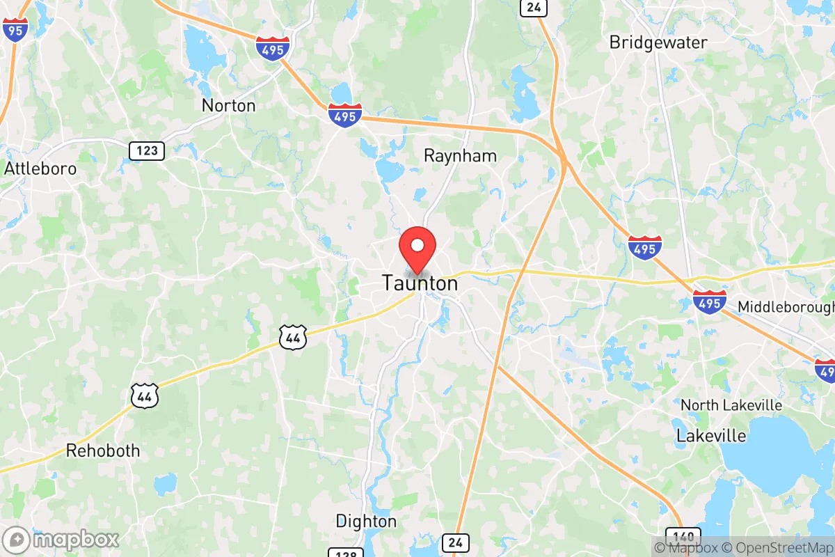
Taunton, Massachusetts, sits in a precarious strategic position that demands serious consideration for anyone prioritizing long-term resilience. While its location roughly 40 miles south of Boston and 20 miles east of Providence offers some buffer from immediate urban chaos, the city itself is not a remote stronghold—it's a mid-sized industrial hub with a population around 60,000, embedded in a densely populated region. The real strategic value here lies in its access to the Taunton River, its position along major transportation corridors like I-495 and Route 24, and its proximity to the coastal resources of Mount Hope Bay, but these same features also create significant vulnerabilities. For a relocator thinking in terms of civic unrest, mass casualty events, or societal breakdown, Taunton offers a mixed bag: enough infrastructure to sustain a post-event existence, but enough proximity to high-value targets to make it a secondary risk zone.
Geographic position and natural advantages for long-term survival
Taunton's geography is a double-edged sword, but the natural advantages are worth noting. The city sits on the Taunton River, which flows into Mount Hope Bay and eventually the Atlantic, providing a potential water source and a route for fishing or small-boat transport if roads become impassable. The surrounding area includes the Hockomock Swamp to the north and extensive wetlands to the south, which create natural barriers against easy overland movement—useful for slowing down any organized chaos or looters moving from Boston or Providence. The terrain is generally flat to gently rolling, with some wooded areas in the outskirts like the Taunton River Wildlife Management Area, offering cover and potential for small-scale hunting or foraging. The climate is typical New England: cold winters that can be brutal without prepared shelter, but also a reliable growing season from May to September for those with gardening skills. The city's elevation is low—around 30 feet above sea level—which means flooding is a real concern near the river, but it also means the water table is accessible for wells in the more rural parts of the city limits. For a relocator, the key natural advantage is the river and the wetlands: they provide a natural moat of sorts, making Taunton less immediately accessible than inland towns like Raynham or Norton, but also limiting escape routes if the area becomes compromised.
Risks, exposures, and proximity to fallout-relevant landmarks
This is where the analysis gets serious. Taunton's proximity to high-value targets is its greatest liability. Boston is 40 miles north, a major population center with federal buildings, financial districts, and the Port of Boston—a prime target for any coordinated attack or civil unrest. Providence is even closer at 20 miles west, with its own port and industrial infrastructure. But the more immediate concern is the cluster of critical infrastructure within a 30-mile radius: the Pilgrim Nuclear Power Station in Plymouth (about 25 miles northeast), which is decommissioned but still contains spent fuel; the Brayton Point Power Station in Somerset (about 10 miles south), a former coal plant now being redeveloped for offshore wind, but still a potential industrial hazard; and the numerous chemical plants along the Taunton River itself, including the Koch Industries-owned facility in nearby Freetown. A mass casualty event or EMP strike could render the entire region a secondary disaster zone from fallout, fires, or chemical releases. The city is also crisscrossed by major highways—I-495, Route 24, and Route 140—which in a collapse scenario would become chokepoints for fleeing populations from Boston and Providence. Taunton's own population density, at roughly 1,200 people per square mile, means you're never truly isolated; your neighbors will be competing for the same resources. For a prepper, the risk profile here is moderate-to-high: not as exposed as living inside Boston, but far from the safety of rural Maine or New Hampshire.
Practical resilience for a relocator: food, water, energy, and defensibility
If you're considering Taunton as a base, you need to think in terms of immediate post-event sustainability. The city has a municipal water system drawing from the Taunton River and Assawompset Pond, but in a grid-down scenario, that system will fail within hours. You'll need a backup plan: the river is accessible but heavily polluted from industrial runoff, so you'd need advanced filtration or a deep well on your property. The outskirts of the city, like the neighborhoods near the Myles Standish Industrial Park or the rural areas around Lake Sabbatia, offer better well potential, but those properties are expensive and hard to come by. Food resilience is weak: Taunton has a few supermarkets (Stop & Shop, Shaw's) and a farmers' market in the summer, but no significant agricultural base within city limits. You'd need to rely on stockpiling or gardening, and the growing season is short. Energy is a mixed bag: the grid is reliable in normal times, but the area is prone to nor'easters that can knock out power for days. Solar is viable but not ideal due to the region's cloud cover; a generator with stored fuel is a must. Defensibility is the hardest sell. Taunton is a compact city with a dense downtown core, narrow streets, and limited sightlines. A single-family home on the outskirts with a cleared perimeter and a well-stocked armory could be held, but you're surrounded by neighbors, and the police response time in a widespread event would be measured in hours or days. The city's police force is about 100 officers, but they'll be overwhelmed in any large-scale crisis. For a single individual or a family, the best bet is to find a property on the northern or eastern edges, near the wetlands, where you have natural barriers and fewer approach vectors. But honestly, if you're serious about long-term survival, Taunton is a staging ground, not a final destination.
The overall strategic picture for Taunton is one of calculated risk. It's not a survivalist's paradise—it's a compromise between access to resources and exposure to threats. The city's location offers decent water access, some natural barriers, and proximity to coastal resources, but the density, industrial hazards, and proximity to major urban centers make it a secondary risk zone in any large-scale event. For a relocator with a conservative, prepper mindset, Taunton could work as a temporary base while you scout more defensible terrain in central or western Massachusetts, or even New Hampshire. But if you're looking for a place to hunker down for the long haul, you'd be better off looking at towns like Middleborough or Lakeville to the south, or even heading further west to the Berkshires. Taunton is a place to pass through, not to plant roots, unless you're willing to invest heavily in off-grid infrastructure and maintain a low profile. The bottom line: it's a decent option for the first 72 hours, but after that, the risks start to outweigh the rewards. Plan accordingly.
* Values derived from national, state, county, city and local statistics and may differ in a specific area. Last updated: 2026-05-01T07:34:21.000Z
Narrative content on this page is AI-generated and may contain mistakes. Verify any details that matter before acting on them.
ReloMaps may earn a commission from affiliate links at no extra cost to you.