Photo: Wikipedia
Strategic Assessment of Coffee County
Workable tactical position. Some exposure to population density or targets, but generally defensible in a crisis.
What does the Strategic Assessment tell us?
Our Strategic Assessment grades tactical survivability of an area. Major population centers, military targets, fallout zones, natural disasters, and border exposure all drive risk — lower exposure means a more defensible position in a crisis.
This is heavily inspired by Joel Skousen's Strategic Relocation book. Highly recommended you checkout the book ($)What does this tell us?
Our Strategic Assessment grades tactical survivability of an area. Major population centers, military targets, fallout zones, natural disasters, and border exposure all drive risk — lower exposure means a more defensible position in a crisis.
This is heavily inspired by Joel Skousen's Strategic Relocation book. Highly recommended you checkout the book ($)Strategic Pillars

Key Distances
Strategic Assessment Analysis
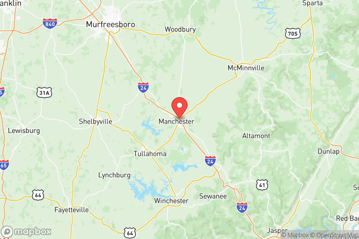
Coffee County, Tennessee, occupies a strategic sweet spot that resilience-minded relocators should scrutinize closely. Its position roughly 70 miles southeast of Nashville and 40 miles northwest of Chattanooga places it within a day’s drive of major population centers, yet far enough from their immediate blast radii and civil unrest zones to offer genuine buffer. The county’s rolling hills, abundant water, and historically stable governance make it a credible candidate for those seeking a prepared, self-sufficient lifestyle without the extreme isolation of deep Appalachia or the high costs of the Western states.
Geographic position and natural advantages for long-term security
Coffee County sits atop the Eastern Highland Rim, a plateau that provides natural elevation advantages over the flood-prone basins of Middle Tennessee. The county seat, Manchester, lies at roughly 1,050 feet above sea level, while Tullahoma sits even higher at 1,070 feet. This elevation reduces the risk of flash flooding and offers cooler summer temperatures, which matters for both daily comfort and agricultural viability. The area is drained by the Duck River and its tributaries, including the Barren Fork and Little Duck River, which provide reliable surface water sources even during moderate drought. The underlying geology includes the Arnold Air Force Base area, which sits on the Highland Rim’s limestone karst—a mixed blessing, as it means good groundwater recharge but also potential sinkhole risks in localized spots. For a relocator, the key takeaway is that Coffee County has defensible terrain: the hills and hollows offer natural chokepoints, and the county’s road network (primarily I-24 and US-41) can be monitored from elevated positions. The Old Stone Fort State Archaeological Park in Manchester, a prehistoric Native American enclosure, hints at the area’s long history as a strategic gathering point—a legacy that still holds value for those thinking in terms of community and security.
Risks, exposures, and proximity to fallout-relevant landmarks
No strategic assessment is honest without confronting the downsides. Coffee County’s primary risk exposure comes from its proximity to Arnold Air Force Base (officially Arnold Engineering Development Complex), a major U.S. Air Force testing and evaluation center located just south of Tullahoma. While the base is not a nuclear storage site per open-source data, it houses hypersonic and missile testing facilities that could make it a secondary target in a major conflict. The base’s presence also means a steady flow of military personnel and contractors, which adds a layer of economic stability but also potential surveillance or movement restrictions during heightened alert levels. Additionally, the county lies within 100 miles of the Sequoyah Nuclear Plant near Chattanooga and the Watts Bar Nuclear Plant near Spring City—both are potential fallout sources if compromised. The prevailing winds in Middle Tennessee generally blow from the southwest, meaning a release from Sequoyah could push contamination toward Coffee County within hours. On the civil unrest front, Nashville and Chattanooga are both within a 90-minute drive, and their respective urban cores could become flashpoints during economic collapse or political turmoil. Coffee County’s small cities—Manchester (pop. ~10,000) and Tullahoma (pop. ~20,000)—are not immune to spillover violence, but their low population density and strong local law enforcement presence (including the Coffee County Sheriff’s Office and Tullahoma Police Department) provide a better baseline than suburban sprawl. The Interstate 24 corridor is a double-edged sword: it enables rapid evacuation or supply movement, but also serves as a highway for refugees fleeing Nashville or Chattanooga during a crisis.
Practical resilience for a relocator: food, water, energy, and defensibility
For a family or individual serious about self-sufficiency, Coffee County offers concrete advantages. Water is the first pillar: the Duck River watershed provides ample surface water, and the county’s average annual rainfall of 54 inches means rainwater catchment is viable year-round. Well drilling is common, with typical depths of 100-300 feet reaching the limestone aquifer, though water quality varies and testing is essential. The county has no municipal water restrictions that would hamper a prepper’s garden or livestock operation. Food production is supported by a growing network of small farms, with the Manchester Farmers Market and Tullahoma’s local food scene indicating a community that values local sourcing. The growing season runs roughly April through October, with hardiness zones 6b and 7a allowing for a wide range of vegetables, fruits, and even some nut trees. For energy resilience, the Tennessee Valley Authority (TVA) grid is reliable but vulnerable to EMP or cyberattack; solar panels with battery storage are increasingly common, and the county’s building codes do not prohibit off-grid setups. The Timberland Park area and the Rutledge Falls region offer wooded parcels that provide both timber for heating and natural concealment. Defensibility is aided by the county’s topography: the Highland Rim’s escarpment creates natural barriers to the east and west, and the many rural roads (like Old Manchester Highway and Bomar Road) can be monitored or blocked with minimal effort. The Arnold Air Force Base buffer zone to the south also limits development, creating a sparsely populated corridor that could serve as a security perimeter. For community resilience, the county has a strong church network and a history of volunteer fire departments, which are indicators of social cohesion that matter more than any government program.
The overall strategic picture for Coffee County is one of calculated compromise. It lacks the extreme remoteness of, say, the Idaho panhandle, but it also avoids the crushing isolation that can break unprepared families. Its proximity to military infrastructure is a risk, but that same infrastructure brings jobs, infrastructure spending, and a population that is generally more disciplined and security-conscious than the average. The county’s water abundance, moderate climate, and defensible terrain make it a solid B+ choice for a relocator who wants to be within a day’s drive of medical centers and supply routes, yet far enough from the blast zones and urban chaos to sleep soundly. The key is to buy land with a reliable water source, build or retrofit for passive survivability, and integrate into the local community—not as a prepper outsider, but as a neighbor who can fix a tractor or share a harvest. Coffee County won’t save you from a direct nuclear strike on Arnold AFB, but for the more likely scenarios of economic collapse, supply chain disruption, or localized civil unrest, it offers a realistic foundation for a resilient life.
* Values derived from national, state, county, city and local statistics and may differ in a specific area. Last updated: 2026-05-12T08:54:57.000Z
Narrative content on this page is AI-generated and may contain mistakes. Verify any details that matter before acting on them.
ReloMaps may earn a commission from affiliate links at no extra cost to you.