Photo: Wikipedia
Strategic Assessment of Madison County
Workable tactical position. Some exposure to population density or targets, but generally defensible in a crisis.
What does the Strategic Assessment tell us?
Our Strategic Assessment grades tactical survivability of an area. Major population centers, military targets, fallout zones, natural disasters, and border exposure all drive risk — lower exposure means a more defensible position in a crisis.
This is heavily inspired by Joel Skousen's Strategic Relocation book. Highly recommended you checkout the book ($)What does this tell us?
Our Strategic Assessment grades tactical survivability of an area. Major population centers, military targets, fallout zones, natural disasters, and border exposure all drive risk — lower exposure means a more defensible position in a crisis.
This is heavily inspired by Joel Skousen's Strategic Relocation book. Highly recommended you checkout the book ($)Strategic Pillars

Key Distances
Strategic Assessment Analysis
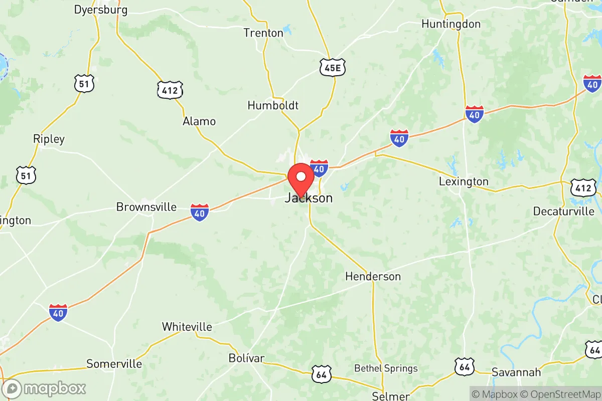
Madison County, Tennessee, offers a strategic balance of rural accessibility and logistical connectivity that appeals to those prioritizing resilience and self-reliance. Anchored by the city of Jackson, the county sits roughly 80 miles east of Memphis and 120 miles west of Nashville, placing it outside the immediate blast or fallout zones of major metropolitan targets while still providing access to critical supply routes like Interstate 40 and U.S. Highway 45. For a conservative-leaning relocator concerned with civic stability and disaster preparedness, this position provides a buffer from urban chaos without isolating you from necessary infrastructure—a rare sweet spot in the Mid-South.
Geographic position and natural advantages for long-term security
Madison County’s geography works in your favor. The terrain is gently rolling, with the Forked Deer River and its tributaries cutting through the area, offering reliable water sources and natural drainage—critical for both agriculture and flood mitigation. The county sits on the western edge of the Tennessee Valley, meaning it’s less prone to the tornado alley extremes of the Plains but still sees occasional severe weather. The soil is fertile, supporting row crops like soybeans and corn, which matters if you’re thinking about long-term food security. Jackson itself is a regional medical hub, with Jackson-Madison County General Hospital providing Level II trauma care—a significant asset if SHTF and you need surgical support without driving to Memphis. The area’s elevation, averaging around 400 feet, offers no strategic high ground but also no floodplain liabilities like those found along the Mississippi River. For a prepper, the key takeaway is that Madison County has defensible natural resources—water, arable land, and moderate climate—without the extreme weather or seismic risks that plague other regions.
Risks, exposures, and proximity to fallout-relevant landmarks
No area is without exposure, and Madison County has its share. The most obvious risk is proximity to the Memphis metropolitan area, roughly 80 miles west, which includes the Memphis International Airport and major freight rail hubs—both potential targets for civil unrest or infrastructure attacks. The county also sits within 150 miles of the Tennessee Valley Authority’s nuclear plants, including the Browns Ferry Nuclear Plant in Alabama and the Watts Bar Nuclear Plant in Tennessee. While not in the immediate blast radius, prevailing winds from the southwest could carry fallout from a Browns Ferry incident into Madison County. Closer to home, the BNSF Railway mainline runs through Jackson, carrying hazardous materials including crude oil and chemicals—a derailment or sabotage event could contaminate local waterways. The county’s largest industrial employer, the Toyota Bodine Assembly plant, is a potential target for economic disruption but not a primary fallout concern. For the relocator, the calculus is this: Madison County is far enough from high-value targets like Fort Campbell (60 miles north) and Memphis to avoid direct strikes, but close enough to feel secondary effects like refugee flows or supply chain breakdowns. Plan for a 72-hour bug-out route east toward the Tennessee River or south into the Mississippi Delta if things go hot.
Practical resilience for a relocator: food, water, energy, and defensibility
If you’re moving here with a prepper mindset, the practicalities matter. Water is abundant: the Forked Deer River and the Hatchie River to the south provide surface water, and the county’s groundwater aquifer is generally reliable, though well depth varies. Jackson Energy Authority provides municipal power, but rural areas rely on electric cooperatives like Gibson EMC—both have decent restoration records but are vulnerable to ice storms and grid failures. For off-grid capability, solar is viable given the region’s 210 sunny days per year, though tree cover in the northern part of the county may require clearing. Food resilience is strong: Madison County has active farmers’ markets, local livestock operations, and the West Tennessee Research and Education Center in Jackson, which offers agricultural extension resources. Defensibility is moderate—the county is mostly flat farmland with scattered woodlots, meaning you’ll need to choose a property with natural chokepoints like creek crossings or tree lines to create a security perimeter. The small towns of Medon, Pinson, and Denmark offer lower population density than Jackson proper, with better options for rural retreats. For daily life, the county has a solid base of hardware stores, feed suppliers, and medical clinics—enough to sustain a community if supply chains falter. The biggest gap is ammunition and firearms retail; you’ll want to stock up before moving, as local options are limited to big-box sporting goods.
The overall strategic picture for Madison County is one of calculated risk. It’s not a remote bunker location—you’re still within a day’s drive of Memphis, Nashville, and the I-40 corridor, which means you’ll see refugee traffic and potential civil unrest spillover during a major event. But it’s also not a target-rich environment like the Houston refinery corridor or the Washington D.C. beltway. For the conservative relocator who wants a balance of community, resources, and buffer from urban collapse, Madison County offers a solid B+ grade. The key is to buy land with water access, establish a garden and rainwater catchment early, and build relationships with neighbors in the rural precincts—because when the grid goes down, it’s the local networks that will keep you alive. If you’re looking for a place to ride out the coming instability without going full hermit, this county deserves a serious look.
* Values derived from national, state, county, city and local statistics and may differ in a specific area. Last updated: 2026-05-12T14:06:17.000Z
Narrative content on this page is AI-generated and may contain mistakes. Verify any details that matter before acting on them.
ReloMaps may earn a commission from affiliate links at no extra cost to you.