Photo: Wikipedia
Strategic Assessment of Rockwall County
Meaningful friction. Expect exposure to either population pressure, blast zones, or natural disaster risk. Consider buying a retreat property.
What does the Strategic Assessment tell us?
Our Strategic Assessment grades tactical survivability of an area. Major population centers, military targets, fallout zones, natural disasters, and border exposure all drive risk — lower exposure means a more defensible position in a crisis.
This is heavily inspired by Joel Skousen's Strategic Relocation book. Highly recommended you checkout the book ($)What does this tell us?
Our Strategic Assessment grades tactical survivability of an area. Major population centers, military targets, fallout zones, natural disasters, and border exposure all drive risk — lower exposure means a more defensible position in a crisis.
This is heavily inspired by Joel Skousen's Strategic Relocation book. Highly recommended you checkout the book ($)Strategic Pillars

Key Distances
Strategic Assessment Analysis
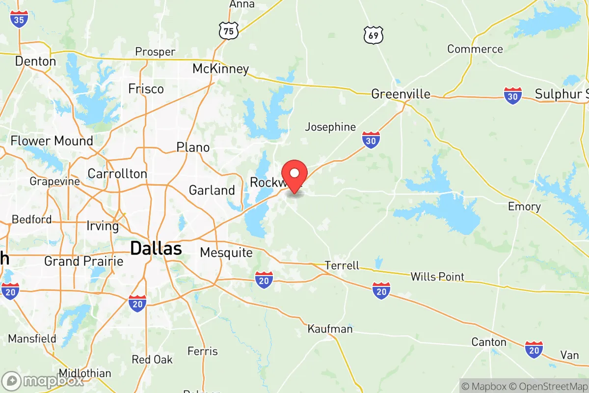
Rockwall County, Texas, presents a mixed strategic picture for the conservative prepper or survivalist. Its primary advantage is its position on the eastern edge of the Dallas-Fort Worth metroplex, offering a buffer from the immediate chaos of a major urban collapse while still providing access to critical infrastructure. The county’s resilience is anchored by its location on Lake Ray Hubbard, a massive 22,000-acre reservoir that serves as both a water source and a natural defensive barrier to the west. However, this proximity to a major metropolitan area—and the fallout-relevant landmarks within it—introduces significant exposure risks that cannot be ignored. For the relocator prioritizing self-sufficiency and security, Rockwall County is a study in trade-offs: excellent natural resources and a relatively low population density for a suburban county, but with a vulnerability corridor that runs straight through the heart of the region.
Geographic position and natural advantages for long-term survival
Rockwall County’s geography is its strongest card. The county sits on the western shore of Lake Ray Hubbard, a man-made reservoir that provides a reliable, if not pristine, water source. The lake itself is a natural barrier—any approach from the Dallas side must cross one of two major bridges (Interstate 30 or State Highway 66), both of which can be monitored or controlled in a crisis. The county’s terrain is gently rolling, with a mix of blackland prairie and post oak savanna, offering decent soil for small-scale agriculture and ample cover for discreet homesteading. The city of Rockwall, the county seat, is the population center, but the surrounding unincorporated areas—like the rural stretches near Fate and Royse City—offer more acreage and lower visibility. The county’s position on the Balcones Fault line is a minor seismic risk, but the real advantage is the absence of major floodplains outside the lake’s immediate shore. For a relocator, the ability to draw water from the lake, drill a private well (the Trinity Aquifer is accessible at moderate depth), and grow food on the fertile clay-loam soil makes this a viable long-term retreat zone—provided you can secure a property with enough land to be self-sufficient.
Risks, exposures, and proximity to fallout-relevant landmarks
The biggest liability is proximity to Dallas and its surrounding infrastructure. Rockwall County is roughly 25 miles east of downtown Dallas, placing it within the blast and fallout radius of any major attack on the city’s financial district or government centers. More critically, the county is within 30 miles of the Dallas Love Field airport and the Dallas Naval Air Station (though the latter is primarily a reserve facility). The real concern is the concentration of petrochemical and industrial targets along the I-30 corridor. The Valero refinery in nearby Mount Pleasant is over 100 miles away, but the smaller refineries and chemical plants in the Dallas-Fort Worth area—like the ExxonMobil facility in Irving—are close enough that a major incident could send a toxic plume across the lake. Additionally, the county is directly under the flight path for both DFW International Airport and Love Field, meaning any airborne event (a dirty bomb, a plane crash, or a coordinated attack) could deposit fallout directly onto Rockwall County. The county’s population density is a double-edged sword: at roughly 1,100 people per square mile, it’s not a rural haven, but it’s far less congested than Dallas County’s 3,000+ per square mile. The risk of civil unrest spilling over from Dallas is real—the I-30 bridge is a natural chokepoint, but it also funnels any fleeing population directly into Rockwall County. For the prepper, the key is to secure a property east of the lake, away from the main evacuation routes, and to have a plan for sealing off access points if the situation deteriorates.
Practical resilience for a relocator: food, water, energy, and defensibility
Water is the county’s strongest asset. Lake Ray Hubbard is a massive, publicly accessible reservoir, but relying on it for drinking water requires treatment—boiling, filtration, or chemical purification. Private wells are common in the rural parts of the county, with depths ranging from 200 to 400 feet to reach the Trinity Aquifer. The water quality is generally good, but testing for agricultural runoff and industrial contaminants is advisable. Food resilience is moderate: the county has a few small-scale farms and ranches, but most food is imported from outside. A relocator should plan to establish a garden immediately—the growing season is long (March to November), and the soil is workable. Energy infrastructure is a vulnerability. Rockwall County is served by Oncor, the regional grid operator, and is subject to the same rolling blackouts and grid instability that plagued Texas during Winter Storm Uri. Solar panels with battery storage are a wise investment, as the county gets over 230 sunny days per year. Natural gas is available in most subdivisions, but a backup propane tank or wood-burning stove is essential for winter heating. Defensibility is mixed. The lake provides a natural barrier to the west, but the county is flat and open in many areas, making it hard to secure a large perimeter. The best defensive properties are those with tree cover, a long driveway, and a clear line of sight to the main road. The county’s law enforcement presence is adequate for a suburban area—the Rockwall County Sheriff’s Office and the Rockwall Police Department are well-funded—but in a widespread collapse, they would be overwhelmed. The local population is predominantly conservative and gun-friendly, which is a positive for community defense, but it also means that any resource scarcity could lead to armed conflict with neighbors. The key is to keep a low profile, build relationships with like-minded locals, and avoid drawing attention to your supplies.
The overall strategic picture for Rockwall County is one of cautious viability. It is not a remote, off-grid paradise—it is a suburban county with a strong natural buffer and decent resources, but with significant exposure to the risks of a major metropolitan area. For the relocator who can secure a property with land, a well, and a defensible position east of the lake, it offers a realistic base for weathering short-to-medium-term disruptions. The proximity to Dallas is a double-edged sword: it provides access to medical facilities, supply chains, and a large labor market in normal times, but it becomes a liability during a crisis. The county’s conservative culture and relatively low crime rate (violent crime is about half the national average) are positives, but they do not eliminate the risk of civil unrest spilling over from the city. In short, Rockwall County is a solid B+ option for the strategic relocator—better than being inside Dallas, but not as secure as a truly rural county in the Texas Hill Country or the Piney Woods. If you can manage the trade-offs, it is a defensible, resource-rich location that can sustain a prepared family through most scenarios short of a direct nuclear strike on the metroplex.
* Values derived from national, state, county, city and local statistics and may differ in a specific area. Last updated: 2026-05-28T02:14:59.000Z
Narrative content on this page is AI-generated and may contain mistakes. Verify any details that matter before acting on them.
ReloMaps may earn a commission from affiliate links at no extra cost to you.