Photo: Alex Reynolds via Unsplash
Strategic Assessment of The Cliffs Valley, SC
Workable tactical position. Some exposure to population density or targets, but generally defensible in a crisis.
What does the Strategic Assessment tell us?
Our Strategic Assessment grades tactical survivability of an area. Major population centers, military targets, fallout zones, natural disasters, and border exposure all drive risk — lower exposure means a more defensible position in a crisis.
This is heavily inspired by Joel Skousen's Strategic Relocation book. Highly recommended you checkout the book ($)What does this tell us?
Our Strategic Assessment grades tactical survivability of an area. Major population centers, military targets, fallout zones, natural disasters, and border exposure all drive risk — lower exposure means a more defensible position in a crisis.
This is heavily inspired by Joel Skousen's Strategic Relocation book. Highly recommended you checkout the book ($)Strategic Pillars

Key Distances
Regional Safe Places
Below is our recommended "safe zones" in South Carolina and the surrounding area based on our strategic heuristics. For most people, it's unrealistic to live in a “safe zone” full-time due to work, family or other personal reasons. They tend to be more rural. However, many of these areas are perfect for second homes and retreat properties that double as a vacation home or even a short-term rental.


Important Note: For informational purposes only. This does not mean nothing bad ever happens in the green zones. Please use common sense. This is based on public data and modeled with AI. We tried to take a conservative approach but mistakes happen. We update this regularly as new information becomes available.
Solar Generator Recommendations
Backup power matters more here than in safer locations. We've picked three solar generators across budgets and capacity tiers — start with the budget unit if you only need a few essentials, or step up if you want to run a fridge and HVAC for days at a time.

Jackery Portable Power Station Explorer 300
Budget OptionPower on the Go: Weighing only 11 lbs, it's convenient to set up and store with book-sized foldable solar panels

BLUETTI Portable Power Station AC180
Designed for both indoor and outdoor scenarios, AC180 is highly capable as it has a robost capacity and continuous output power.

EF ECOFLOW DELTA Pro Ultra Power Station
Upgraded PickEcoFlow DELTA Pro Ultra is a whole-home energy system designed to grow with your family. Integrated with the Smart Home Panel 2, it scales to meet your evolving energy needs — keeping your home powered, intelligent, and secure through every stage of life.
We earn a commission, at no additional cost to you.
Strategic Assessment Analysis
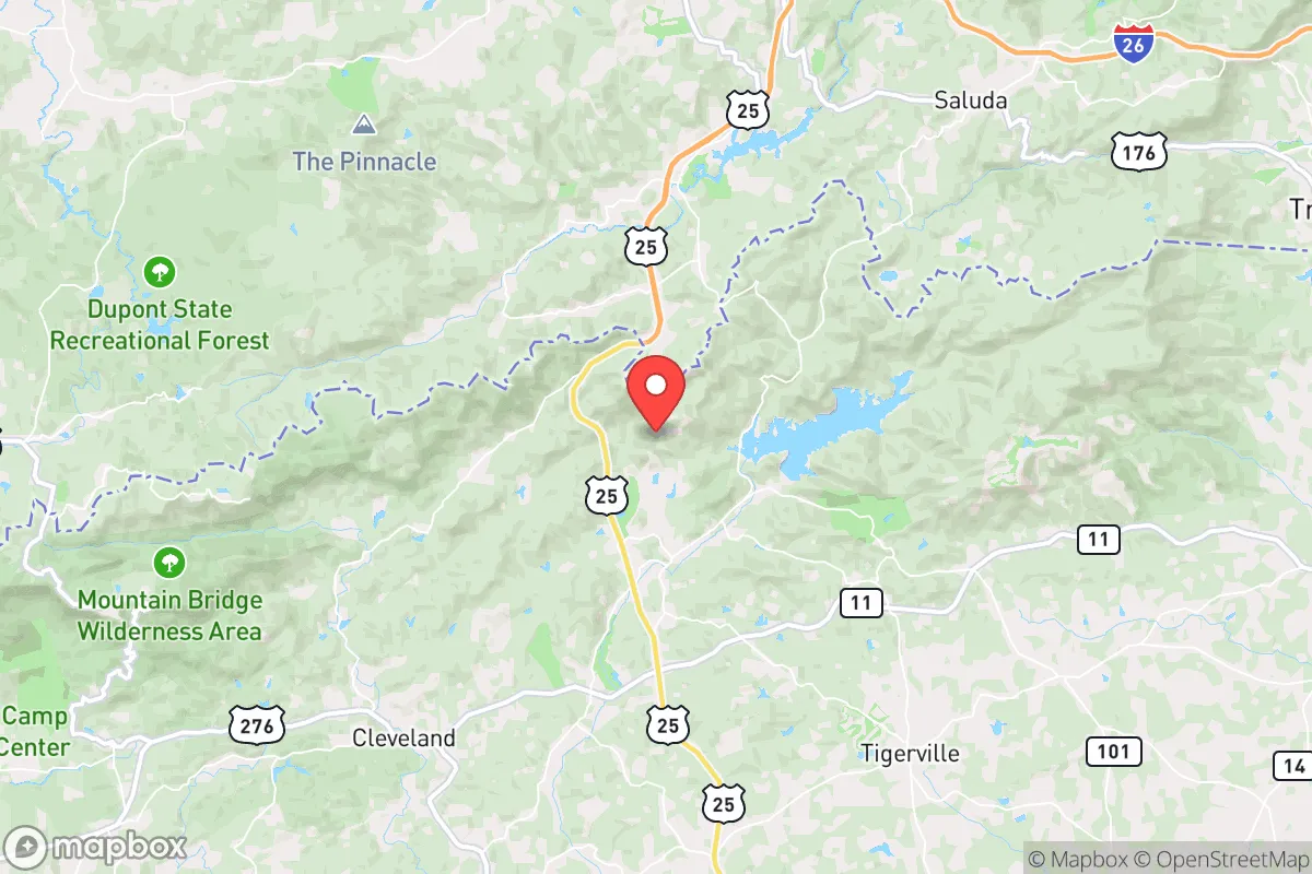
The Cliffs Valley, South Carolina, offers a compelling strategic position for those prioritizing resilience, combining the seclusion of the Blue Ridge foothills with a buffer from the most acute risks of the coastal plain and major urban corridors. Located in northern Greenville County, near the North Carolina border, this gated community sits roughly 30 miles from downtown Greenville and 45 miles from Asheville, NC—close enough for supply runs but far enough to avoid the immediate chaos of a metropolitan collapse. The area’s elevation, typically between 1,000 and 1,500 feet, provides a natural advantage against flooding and storm surge, while the surrounding mountains and national forest land create a defensible perimeter that is difficult to approach unnoticed. For a relocator concerned with civic unrest, mass casualty events, or large-scale disasters, this is a location that balances access with isolation, though it is not without its own exposures.
Geographic position and natural defensive advantages
The Cliffs Valley sits within the Southern Appalachian ecoregion, a landscape defined by ridges, valleys, and dense hardwood forests that offer both cover and chokepoints. The community is nestled along the North Saluda River and near the headwaters of the Saluda River, which flows south toward Lake Greenwood and eventually the Atlantic—meaning water sources are upstream and less likely to be contaminated by downstream industrial or population centers. The surrounding Pisgah National Forest and Sumter National Forest provide a buffer of public land that is difficult to develop or densely populate, reducing the likelihood of refugee flows or opportunistic looting parties moving through the area. Elevation above 1,000 feet also places The Cliffs Valley outside the primary fallout plume zones for major targets like Charlotte (90 miles east) or the Savannah River Site (80 miles south), though prevailing winds from the west-northwest would carry any fallout from the Oak Ridge National Laboratory in Tennessee (roughly 100 miles northwest) toward the Atlantic, largely bypassing this valley. The terrain itself is a defensive asset: narrow two-lane roads like SC-11 and US-276 create natural ambush points and can be easily blocked or monitored, while the gated entrance to the community provides a first layer of access control. For a prepper, the ability to observe approaching threats from elevated ridgelines and to funnel movement through a few key passes is a significant tactical advantage.
Risks, exposures, and proximity to fallout-relevant landmarks
No location is immune to risk, and The Cliffs Valley has several exposures that a strategic relocator must weigh. The most immediate concern is the Savannah River Site (SRS), a nuclear weapons facility and waste storage complex located about 80 miles south, near Aiken, SC. While this distance provides some safety from a direct blast or fire, a major accident or sabotage event at SRS could release radioactive material that, depending on wind patterns, might drift into the Upstate. The prevailing winds in this region are from the west and southwest, meaning SRS fallout would likely move northeast toward Columbia and Charlotte, but a shift during a weather event could push contamination into the Greenville-Asheville corridor. Similarly, the Oak Ridge National Laboratory in Tennessee, which handles enriched uranium and other nuclear materials, is roughly 100 miles northwest—close enough that a worst-case release could reach the area within hours under certain conditions. Beyond nuclear risks, the area is vulnerable to severe thunderstorms, tornadoes (the Upstate sits in the southern edge of Dixie Alley), and occasional ice storms that can knock out power for days or weeks. Greenville’s growing population (over 70,000 within city limits, 500,000+ in the metro) means that a major disaster could trigger a refugee exodus north along I-85 and US-25, potentially overwhelming local resources. The Cliffs Valley’s gated status helps, but it is not a fortress; a determined group could breach the entrance, and the community’s reliance on outside supply chains for food, fuel, and medical care is a vulnerability that must be addressed through stockpiling and local sourcing.
Practical resilience for a relocator: food, water, energy, and defensibility
For a single individual or family looking to establish a long-term resilient homestead, The Cliffs Valley offers a mixed but workable foundation. Water is the strongest asset: the North Saluda River and numerous springs provide a reliable surface water source that can be filtered or boiled, and the area’s average annual rainfall of 50-60 inches ensures that rainwater catchment systems are highly effective. The soil in the valley bottoms is loamy and well-drained, suitable for vegetable gardens, though the rocky slopes limit large-scale agriculture. Deer, turkey, and small game are abundant in the surrounding forests, providing a protein source for those with hunting skills and proper permits. Energy resilience is more challenging: the community is connected to the Duke Energy grid, which is generally reliable but vulnerable to ice storms and cyberattacks. Solar panels are feasible given the region’s 200+ sunny days per year, but tree cover in the valley can reduce efficiency, so rooftop or clearing-mounted arrays are recommended. Propane backup generators are common in the area, and a 500-gallon tank can provide weeks of power for a modest home. Defensibility is enhanced by the community’s layout: homes are spaced on large lots (typically 1-5 acres), with many properties backing onto national forest or undeveloped land, creating a natural buffer. The HOA, while restrictive on some prepper activities like visible stockpiles or certain outbuildings, also enforces standards that prevent neighbors from becoming liabilities. For a relocator, the key is to build relationships with nearby landowners and establish mutual-aid agreements before a crisis hits—isolation is a double-edged sword, and a small network of trusted allies can make the difference between survival and vulnerability.
The overall strategic picture for The Cliffs Valley is one of calculated trade-offs. It offers a rare combination of natural defensibility, water security, and proximity to wilderness that is hard to find in the Southeast, while remaining within a few hours of major medical and supply hubs for peacetime living. The risks from nuclear facilities and potential refugee flows from Greenville are real but manageable with proper planning—maintaining a low profile, stockpiling at least three months of supplies, and establishing off-grid power and water systems. For a conservative-leaning relocator who values self-reliance and community but wants to avoid the extremes of deep rural isolation or urban vulnerability, this area represents a solid middle ground. It is not a bug-out location for a complete societal collapse—the gated community model depends on some level of order—but for weathering a period of unrest, economic disruption, or localized disaster, The Cliffs Valley provides a defensible, resource-rich base that is worth serious consideration.
* Values derived from national, state, county, city and local statistics and may differ in a specific area. Last updated: 2026-04-23T03:13:27.000Z
Narrative content on this page is AI-generated and may contain mistakes. Verify any details that matter before acting on them.
ReloMaps may earn a commission from affiliate links at no extra cost to you.