Photo: Wikipedia
Strategic Assessment of Townsend, MT
Strong survivability profile. Good buffer from population centers, with manageable environmental and tactical risks.
What does the Strategic Assessment tell us?
Our Strategic Assessment grades tactical survivability of an area. Major population centers, military targets, fallout zones, natural disasters, and border exposure all drive risk — lower exposure means a more defensible position in a crisis.
This is heavily inspired by Joel Skousen's Strategic Relocation book. Highly recommended you checkout the book ($)What does this tell us?
Our Strategic Assessment grades tactical survivability of an area. Major population centers, military targets, fallout zones, natural disasters, and border exposure all drive risk — lower exposure means a more defensible position in a crisis.
This is heavily inspired by Joel Skousen's Strategic Relocation book. Highly recommended you checkout the book ($)Strategic Pillars

Key Distances
Regional Safe Places
Below is our recommended "safe zones" in Montana and the surrounding area based on our strategic heuristics. For most people, it's unrealistic to live in a “safe zone” full-time due to work, family or other personal reasons. They tend to be more rural. However, many of these areas are perfect for second homes and retreat properties that double as a vacation home or even a short-term rental.

Important Note: For informational purposes only. This does not mean nothing bad ever happens in the green zones. Please use common sense. This is based on public data and modeled with AI. We tried to take a conservative approach but mistakes happen. We update this regularly as new information becomes available.
Solar Generator Recommendations
Backup power matters more here than in safer locations. We've picked three solar generators across budgets and capacity tiers — start with the budget unit if you only need a few essentials, or step up if you want to run a fridge and HVAC for days at a time.

Jackery Portable Power Station Explorer 300
Budget OptionPower on the Go: Weighing only 11 lbs, it's convenient to set up and store with book-sized foldable solar panels

BLUETTI Portable Power Station AC180
Designed for both indoor and outdoor scenarios, AC180 is highly capable as it has a robost capacity and continuous output power.

EF ECOFLOW DELTA Pro Ultra Power Station
Upgraded PickEcoFlow DELTA Pro Ultra is a whole-home energy system designed to grow with your family. Integrated with the Smart Home Panel 2, it scales to meet your evolving energy needs — keeping your home powered, intelligent, and secure through every stage of life.
We earn a commission, at no additional cost to you.
Strategic Assessment Analysis
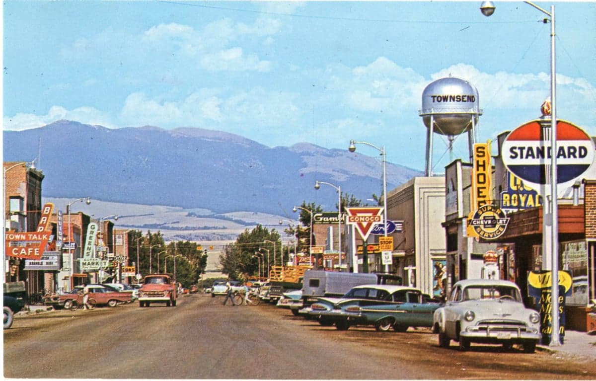
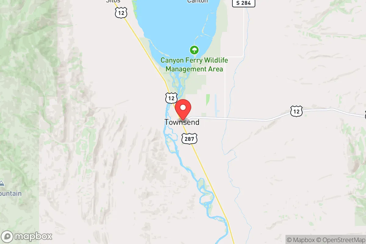
Townsend, Montana, sits in a sweet spot that few relocation analysts fully appreciate: close enough to essential services and supply chains, yet far enough from the major population centers that would become focal points during widespread disruption. This small Broadwater County seat, roughly 35 miles east of Helena and 50 miles west of Bozeman, offers a strategic balance of isolation and accessibility that makes it a serious contender for anyone thinking about long-term preparedness. The town’s position along the Missouri River and its location in a broad valley ringed by mountains give it natural advantages that are hard to replicate in flatter, more exposed parts of the state.
Geographic position and natural advantages for long-term security
Townsend’s geography is its strongest card. The town sits in the Helena Valley, with the Big Belt Mountains to the east and the Elkhorn Mountains to the southwest. This creates a natural bowl that provides some shielding from extreme weather and offers multiple escape routes into higher, more defensible terrain if needed. The Missouri River runs right through town, providing a reliable surface water source that doesn’t depend on municipal infrastructure. The surrounding area is a mix of irrigated farmland, ranchland, and national forest—meaning food production and timber are within easy reach. The nearby Canyon Ferry Lake, a large reservoir just north of town, adds another layer of water security and could support fishing as a protein source. For a relocator thinking about self-sufficiency, Townsend’s position at the intersection of the Missouri River and U.S. Highway 287 gives you both a water corridor and a secondary road network that avoids the congestion of I-90 or I-15. The valley floor is wide enough for small-scale agriculture but narrow enough that a determined group could monitor approaches from the east and west.
Risks, exposures, and proximity to fallout-relevant landmarks
No location is perfect, and Townsend has real vulnerabilities that need to be weighed. The most obvious risk is its proximity to Helena (35 miles west) and Bozeman (50 miles east). Both are growing rapidly and would likely become evacuation destinations during a crisis, meaning Townsend could see a surge of refugees moving through on Highway 287. The town itself has a population of just over 2,000, but Broadwater County totals only about 7,000 residents—so the local infrastructure is thin. A mass influx would strain food supplies, medical capacity, and law enforcement quickly. Another concern is the rail line that runs through Townsend, carrying freight between Helena and points east. In a scenario involving civil unrest or supply chain collapse, rail corridors can become targets or chokepoints. There are no major military installations, nuclear plants, or chemical facilities within a 50-mile radius, which is a positive—but the Malmstrom Air Force Base missile fields in north-central Montana are roughly 150 miles away, and while that’s outside immediate fallout range, it’s worth noting that Montana is a nuclear-armed state. The Helena Regional Airport is a potential target in a worst-case scenario, but at 35 miles, Townsend is far enough to avoid direct blast effects while still being close enough to feel secondary impacts like power grid disruptions or military checkpoints on major roads.
Practical resilience for a relocator: food, water, energy, and defensibility
For someone serious about preparedness, Townsend offers a workable baseline that requires some investment to make truly resilient. Water is the strongest asset: the Missouri River runs year-round, and groundwater is accessible via wells in most parts of the valley. A simple hand pump or solar-powered well pump could keep a household running even if the grid goes down. The river is also a natural barrier on the town’s north side, which could be used defensively if you control the bridges. Food production is viable but not automatic. The valley has good soil for gardens and small-scale farming, and there are existing ranches and hay operations that could be bartered with or absorbed into a community network. However, the growing season is short—about 100 to 120 frost-free days—so cold-hardy crops and greenhouse investment are necessary for year-round food security. Energy is a mixed bag. Townsend gets its power from NorthWestern Energy, which relies on a mix of hydro, coal, and natural gas. The grid is moderately reliable, but rural Montana is prone to winter outages from ice storms and heavy snow. Solar is a strong option here—the valley gets over 200 sunny days per year—and wind is consistent in the passes. A small solar array with battery storage, plus a backup propane generator, would cover most scenarios. Defensibility is decent but not fortress-level. The town itself is laid out in a grid along the highway, which makes it hard to secure as a whole. But the surrounding foothills offer numerous homestead sites with good sightlines and limited access points. Properties on the east side of the valley, toward the Big Belts, are particularly defensible because they’re off the main road and have natural cover. The local sheriff’s office is small—only a handful of deputies—so in a prolonged crisis, community self-policing would become the norm. That’s something to factor in when choosing neighbors.
The overall strategic picture for Townsend is one of moderate risk with high upside for those willing to put in the work. It’s not a bug-out location for people who want to disappear into the wilderness—it’s a working-class Montana town where you can build a resilient life if you’re prepared to invest in water storage, food production, and off-grid energy. The proximity to Helena and Bozeman is a double-edged sword: it gives you access to hospitals, hardware stores, and supply routes, but it also means you’re on the radar of anyone fleeing those cities during a collapse. The key is to position yourself on the periphery of the valley, not in the town center, and to build relationships with local ranchers and farmers before you need them. Townsend won’t save you from every scenario, but for a relocator with a conservative, self-reliant mindset, it’s a solid base of operations that balances isolation with practicality. The Missouri River, the surrounding mountains, and the small-town culture give it a foundation that many more popular Montana destinations lack—and that’s exactly the kind of edge that matters when the world gets unstable.
* Values derived from national, state, county, city and local statistics and may differ in a specific area. Last updated: 2026-04-30T02:42:22.000Z
Narrative content on this page is AI-generated and may contain mistakes. Verify any details that matter before acting on them.
ReloMaps may earn a commission from affiliate links at no extra cost to you.