Photo: Wikipedia
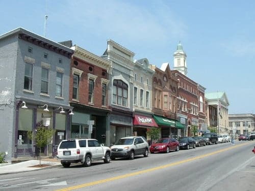
Strategic Assessment of Versailles, KY
Meaningful friction. Expect exposure to either population pressure, blast zones, or natural disaster risk. Consider buying a retreat property.
What does the Strategic Assessment tell us?
Our Strategic Assessment grades tactical survivability of an area. Major population centers, military targets, fallout zones, natural disasters, and border exposure all drive risk — lower exposure means a more defensible position in a crisis.
This is heavily inspired by Joel Skousen's Strategic Relocation book. Highly recommended you checkout the book ($)What does this tell us?
Our Strategic Assessment grades tactical survivability of an area. Major population centers, military targets, fallout zones, natural disasters, and border exposure all drive risk — lower exposure means a more defensible position in a crisis.
This is heavily inspired by Joel Skousen's Strategic Relocation book. Highly recommended you checkout the book ($)Strategic Pillars

Key Distances
Regional Safe Places
Below is our recommended "safe zones" in Kentucky and the surrounding area based on our strategic heuristics. For most people, it's unrealistic to live in a “safe zone” full-time due to work, family or other personal reasons. They tend to be more rural. However, many of these areas are perfect for second homes and retreat properties that double as a vacation home or even a short-term rental.


Important Note: For informational purposes only. This does not mean nothing bad ever happens in the green zones. Please use common sense. This is based on public data and modeled with AI. We tried to take a conservative approach but mistakes happen. We update this regularly as new information becomes available.
Solar Generator Recommendations
Backup power matters more here than in safer locations. We've picked three solar generators across budgets and capacity tiers — start with the budget unit if you only need a few essentials, or step up if you want to run a fridge and HVAC for days at a time.

Jackery Portable Power Station Explorer 300
Budget OptionPower on the Go: Weighing only 11 lbs, it's convenient to set up and store with book-sized foldable solar panels

BLUETTI Portable Power Station AC180
Designed for both indoor and outdoor scenarios, AC180 is highly capable as it has a robost capacity and continuous output power.

EF ECOFLOW DELTA Pro Ultra Power Station
Upgraded PickEcoFlow DELTA Pro Ultra is a whole-home energy system designed to grow with your family. Integrated with the Smart Home Panel 2, it scales to meet your evolving energy needs — keeping your home powered, intelligent, and secure through every stage of life.
We earn a commission, at no additional cost to you.
Strategic Assessment Analysis
Versailles, Kentucky, offers a compelling blend of strategic depth and everyday livability for those prioritizing long-term resilience, but its proximity to major infrastructure and population centers introduces specific vulnerabilities that demand careful consideration. Nestled in the heart of the Bluegrass Region, this Woodford County seat of roughly 10,000 people sits in a sweet spot: close enough to Lexington’s economic engine for supply runs and employment, yet far enough to avoid the immediate chaos of a major urban collapse. The area’s agricultural foundation, strong local governance, and relatively low population density provide a baseline of self-sufficiency that many preppers find attractive, though the region’s reliance on a handful of critical highways and its position within a broader metropolitan shadow require a clear-eyed assessment of risks.
Geographic position and natural advantages for long-term stability
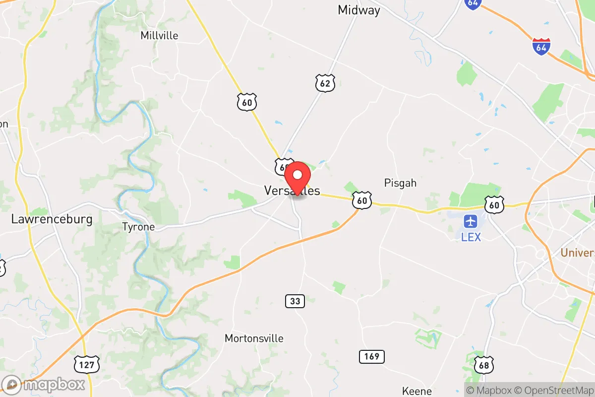
Versailles’ location is its primary strategic asset. The city lies roughly 12 miles west of Lexington, placing it outside the immediate blast radius of any hypothetical urban target while still within a 20-minute drive of major hospitals, supply chains, and regional logistics hubs. The surrounding Woodford County is characterized by rolling limestone hills, deep fertile soils, and an extensive network of creeks and springs that feed the Kentucky River. This topography offers natural defensibility: the area’s winding rural roads and numerous horse farms create a patchwork of private land that slows unauthorized movement and provides ample cover. The local water table is robust, with the Kentucky River and its tributaries providing a reliable surface water source for filtration or diversion. The climate is temperate, with four distinct seasons that support year-round gardening and livestock grazing, though winter ice storms can occasionally disrupt power for days. For a relocator, the ability to grow food, access clean water, and maintain a low profile in a community that values privacy and self-reliance is a significant advantage over more exposed suburban or exurban options.
Risks, exposures, and proximity to fallout-relevant landmarks
The most significant risk for Versailles is its proximity to Lexington’s Blue Grass Airport (LEX) and the associated military and logistics infrastructure. LEX hosts the Kentucky Air National Guard’s 123rd Airlift Wing, which operates C-130 cargo aircraft. In a major conflict or national emergency, this base could become a target for standoff attacks or a chokepoint for military movements, potentially drawing retaliatory strikes or secondary effects like airspace closures and ground traffic jams on US-60 and I-64. Additionally, Versailles sits roughly 60 miles from the Blue Grass Army Depot in Richmond, which stores chemical weapons and conventional munitions. While a direct strike on that facility is unlikely in most scenarios, a major accident or sabotage event could produce a toxic plume that, depending on wind patterns, might affect Woodford County. The city itself has no nuclear power plants within 50 miles, but the Tennessee Valley Authority’s grid connections mean that a broader grid failure could leave Versailles without power for extended periods. The local economy’s heavy reliance on the horse industry—Keeneeland and numerous breeding farms—also creates a single-point-of-failure vulnerability: a livestock disease outbreak or economic downturn in that sector could ripple through the entire county. For the prepper, these risks are manageable but require a plan for self-sufficiency that doesn’t depend on the continued operation of regional infrastructure.
Practical resilience for a relocator: food, water, energy, and defensibility
Versailles scores well on the practical metrics that matter most to a survivalist. Food security is the area’s standout strength: Woodford County is one of Kentucky’s top agricultural producers, with hundreds of farms growing corn, soybeans, hay, and tobacco, plus extensive pasture for cattle and horses. Local farmers’ markets operate year-round in Versailles, and the presence of the Kentucky Department of Agriculture’s headquarters in nearby Frankfort means that emergency food distribution networks are well-established. For those willing to put in the work, the soil is excellent for vegetable gardens, and the climate supports two growing seasons with cold frames. Water access is similarly robust: the Kentucky River runs along the county’s southern border, and numerous springs and wells exist on private land. The city’s municipal water supply comes from the river, but a well with a hand pump or a rainwater catchment system provides a reliable backup. Energy resilience is a mixed bag: the grid is served by Kentucky Utilities, which relies heavily on coal and natural gas, meaning that a fuel supply disruption could cause blackouts. However, the area’s rural character means that many homes already have propane tanks, wood stoves, and backup generators. Solar potential is moderate—the region gets about 200 sunny days per year—but battery storage is advisable for winter months. Defensibility is good but not fortress-level: Versailles’ historic downtown is compact and walkable, but most residential areas are spread out along winding roads with limited choke points. The local sheriff’s office is well-funded and responsive, but in a prolonged crisis, the county’s 25,000 residents would need to rely on neighborhood watch networks and private security measures. The key takeaway: a relocator can achieve a high degree of self-sufficiency here, but it requires upfront investment in water storage, off-grid power, and food preservation infrastructure.
Overall, Versailles presents a balanced strategic picture for the conservative-minded relocator who values preparedness without wanting to live in a remote bunker. The area’s agricultural base, strong community ties, and manageable distance from urban centers offer a realistic path to resilience that doesn’t require abandoning modern conveniences entirely. The primary trade-off is proximity to Lexington’s military and logistics infrastructure—a risk that can be mitigated by choosing a property on the western or southern edges of the county, away from the airport’s flight path and closer to the Kentucky River’s natural barriers. For a single individual or family willing to invest in off-grid capabilities and build relationships with local farmers and tradespeople, Versailles offers a solid foundation for weathering the storms ahead. It is not a bug-out location for a total collapse scenario, but it is a viable long-term base for those who want to be prepared for the more likely disruptions of the next decade: supply chain interruptions, civil unrest in nearby cities, and localized natural disasters. The smart move is to treat Versailles as a hub—a place to establish a home, grow food, and build a network—while maintaining the ability to relocate deeper into the Appalachian foothills if the situation deteriorates further.
* Values derived from national, state, county, city and local statistics and may differ in a specific area. Last updated: 2026-04-21T09:13:36.000Z
Narrative content on this page is AI-generated and may contain mistakes. Verify any details that matter before acting on them.
ReloMaps may earn a commission from affiliate links at no extra cost to you.