

Photo: Wikipedia
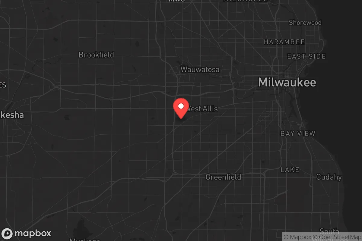
Strategic Assessment of West Allis, WI
Multiple tactical vulnerabilities. Population density, target proximity, or disaster risk are likely compounding. A retreat property and exit planning is required.
What does the Strategic Assessment tell us?
Our Strategic Assessment grades tactical survivability of an area. Major population centers, military targets, fallout zones, natural disasters, and border exposure all drive risk — lower exposure means a more defensible position in a crisis.
This is heavily inspired by Joel Skousen's Strategic Relocation book. Highly recommended you checkout the book ($)What does this tell us?
Our Strategic Assessment grades tactical survivability of an area. Major population centers, military targets, fallout zones, natural disasters, and border exposure all drive risk — lower exposure means a more defensible position in a crisis.
This is heavily inspired by Joel Skousen's Strategic Relocation book. Highly recommended you checkout the book ($)Strategic Pillars

Key Distances
Regional Safe Places
Below is our recommended "safe zones" in Wisconsin and the surrounding area based on our strategic heuristics. For most people, it's unrealistic to live in a “safe zone” full-time due to work, family or other personal reasons. They tend to be more rural. However, many of these areas are perfect for second homes and retreat properties that double as a vacation home or even a short-term rental.
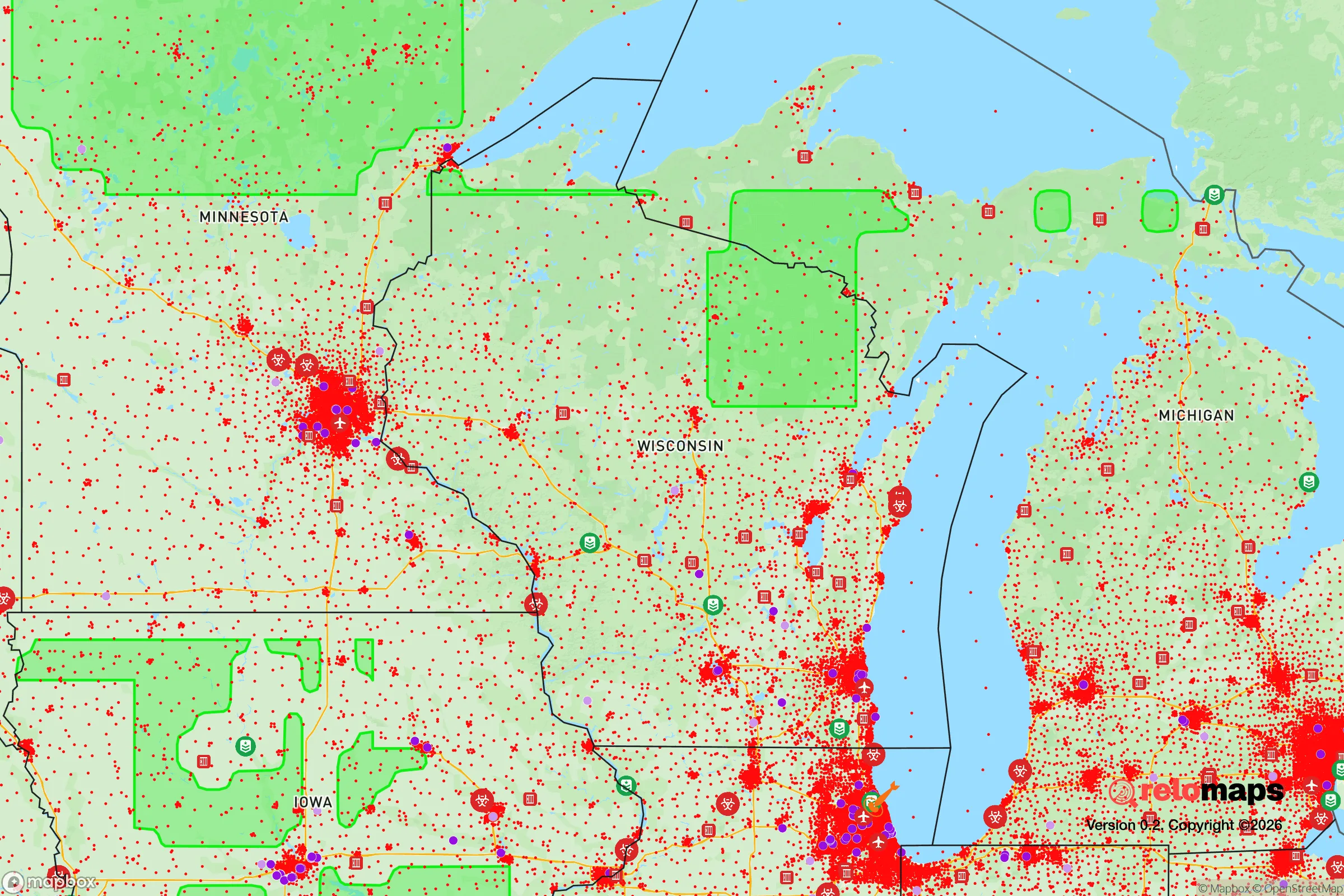
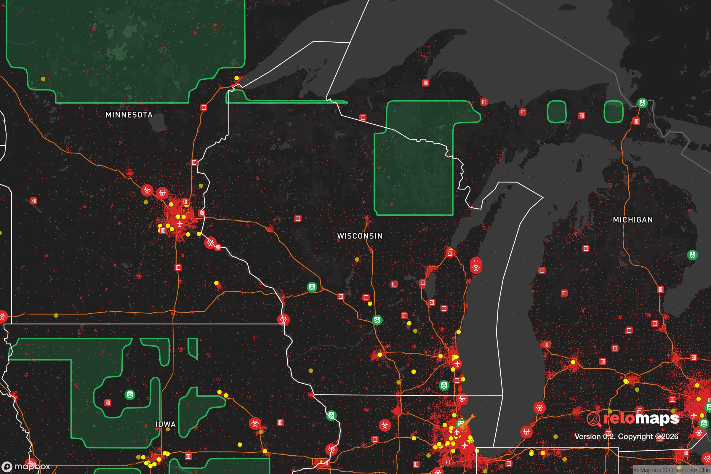
Important Note: For informational purposes only. This does not mean nothing bad ever happens in the green zones. Please use common sense. This is based on public data and modeled with AI. We tried to take a conservative approach but mistakes happen. We update this regularly as new information becomes available.
Solar Generator Recommendations
Backup power matters more here than in safer locations. We've picked three solar generators across budgets and capacity tiers — start with the budget unit if you only need a few essentials, or step up if you want to run a fridge and HVAC for days at a time.

Jackery Portable Power Station Explorer 300
Budget OptionPower on the Go: Weighing only 11 lbs, it's convenient to set up and store with book-sized foldable solar panels

BLUETTI Portable Power Station AC180
Designed for both indoor and outdoor scenarios, AC180 is highly capable as it has a robost capacity and continuous output power.

EF ECOFLOW DELTA Pro Ultra Power Station
Upgraded PickEcoFlow DELTA Pro Ultra is a whole-home energy system designed to grow with your family. Integrated with the Smart Home Panel 2, it scales to meet your evolving energy needs — keeping your home powered, intelligent, and secure through every stage of life.
We earn a commission, at no additional cost to you.
Strategic Assessment Analysis
West Allis, Wisconsin, presents a mixed bag for the strategic relocator. Its location within the Milwaukee metropolitan area offers immediate access to resources and infrastructure, but that same proximity is its greatest vulnerability. For those prioritizing resilience over convenience, West Allis functions less as a standalone redoubt and more as a potential staging ground or a place to monitor before a crisis fully unfolds. The city’s resilience is tied directly to its ability to leverage nearby assets while mitigating the risks of being a dense, urbanized suburb.
Geographic position and natural advantages for a prepper
West Allis sits on a flat, glaciated plain about 5 miles west of downtown Milwaukee, with no significant natural barriers like rivers, hills, or forests to slow movement or provide cover. The terrain is almost entirely developed—residential lots, commercial strips, and industrial parks. The Menomonee River runs along the city’s northern edge, offering a potential water source, but it’s heavily channelized and carries urban runoff. The city’s elevation is roughly 700 feet above sea level, with no floodplain concerns for most properties, but the lack of elevation change means no natural defensive high ground. The primary natural advantage is the proximity to Lake Michigan, about 8 miles east, which provides an essentially unlimited freshwater source—if you can reach it and treat it. The lake also moderates temperatures slightly, reducing extreme cold snaps compared to inland areas, but winters remain harsh with lake-effect snow. For a relocator, the flat, open grid of streets makes the area easy to navigate but hard to defend; there are no chokepoints or natural funnels to control movement.
Risks, exposures, and proximity to fallout-relevant landmarks
This is where West Allis becomes a hard sell for the survival-minded. The city is directly adjacent to Milwaukee’s urban core, meaning any civil unrest, mass casualty event, or disaster in the city will spill over almost immediately. The Mitchell International Airport is just 4 miles southeast, a prime target for any coordinated attack or a source of chaos during a pandemic or evacuation scenario. The I-94 and I-894 interchange cuts through the city’s southern edge, creating a major chokepoint that will clog instantly during an evacuation. Industrial sites along the Menomonee River and near the airport handle chemicals and fuels; a derailment or explosion could contaminate a wide area. The Milwaukee Metropolitan Sewerage District’s Jones Island treatment plant is 7 miles east—a critical infrastructure failure there would affect water quality for the entire region. For a prepper, the biggest exposure is the population density: over 60,000 people in 11 square miles. In a grid-down scenario, that’s 60,000 potential competitors for food, water, and medicine, with no natural buffer to slow their movement into your neighborhood. The city’s police and fire services are competent but will be overwhelmed in any large-scale event.
Practical resilience for a relocator: food, water, energy, and defensibility
On the practical side, West Allis offers some workable options if you’re willing to invest heavily in self-sufficiency. Municipal water comes from Lake Michigan via the Milwaukee Water Works, which is a robust system, but it’s vulnerable to power loss and contamination. A well is not an option in this dense urban area; you’ll need to store water or have a high-capacity filtration system for the Menomonee River or rainwater collection. Food access is decent in normal times—there are multiple grocery stores, including a Woodman’s Market in nearby Menomonee Falls, but supply chains will break quickly in a crisis. Gardening space is limited to small backyards; community gardens exist but are few. Energy reliability is average; We Energies serves the area, and power outages from storms are common but usually short. Solar panels are feasible on many roofs, but the city’s zoning and homeowners’ associations can be restrictive. For defensibility, the standard suburban layout of single-family homes with attached garages and fenced yards offers some perimeter control, but the grid street pattern means multiple approach vectors. Neighborhood watch and community cohesion vary block by block; some areas have active associations, others are transient rentals. A relocator would need to build strong local relationships quickly—this is not a place to go it alone. The West Allis Farmers Market is a good resource for local food networks, but it’s seasonal and not a survival supply line.
The overall strategic picture for West Allis is one of calculated risk. It’s not a retreat or a bug-out location; it’s a place to live with eyes open and a plan to leave if things go sideways. The city’s advantages—proximity to Lake Michigan, established infrastructure, and a working-class population that tends to be self-reliant—are real but overshadowed by the vulnerabilities of density, lack of natural defenses, and proximity to high-value targets. For a conservative-leaning relocator who values community and is willing to invest in hardening a home and building a local network, West Allis could serve as a base of operations for monitoring the region. But for anyone serious about long-term survival, the best use of West Allis is as a stepping stone to more defensible rural areas in Waukesha or Washington counties, where land, water, and distance from Milwaukee’s chaos offer a far better risk-reward ratio. If you’re set on staying, prioritize water storage, a reliable vehicle with a full tank, and a plan to get north or west within the first 24 hours of any major event. West Allis is not a fortress—it’s a forward operating base, and you need to treat it as such.
* Values derived from national, state, county, city and local statistics and may differ in a specific area. Last updated: 2026-04-21T10:03:45.000Z
Narrative content on this page is AI-generated and may contain mistakes. Verify any details that matter before acting on them.
ReloMaps may earn a commission from affiliate links at no extra cost to you.