Photo: Wikipedia
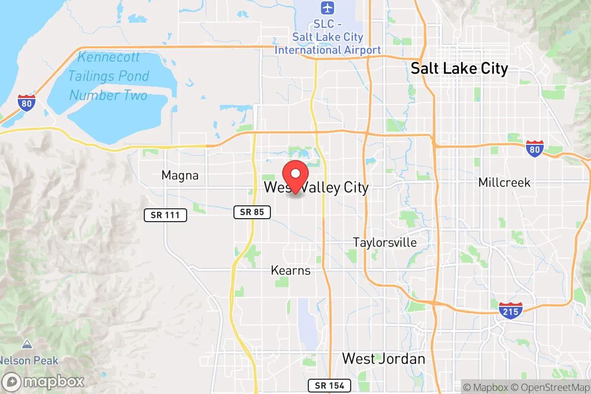
Strategic Assessment of West Valley City, UT
Workable tactical position. Some exposure to population density or targets, but generally defensible in a crisis.
What does the Strategic Assessment tell us?
Our Strategic Assessment grades tactical survivability of an area. Major population centers, military targets, fallout zones, natural disasters, and border exposure all drive risk — lower exposure means a more defensible position in a crisis.
This is heavily inspired by Joel Skousen's Strategic Relocation book. Highly recommended you checkout the book ($)What does this tell us?
Our Strategic Assessment grades tactical survivability of an area. Major population centers, military targets, fallout zones, natural disasters, and border exposure all drive risk — lower exposure means a more defensible position in a crisis.
This is heavily inspired by Joel Skousen's Strategic Relocation book. Highly recommended you checkout the book ($)Strategic Pillars

Key Distances
Regional Safe Places
Below is our recommended "safe zones" in Utah and the surrounding area based on our strategic heuristics. For most people, it's unrealistic to live in a “safe zone” full-time due to work, family or other personal reasons. They tend to be more rural. However, many of these areas are perfect for second homes and retreat properties that double as a vacation home or even a short-term rental.


Important Note: For informational purposes only. This does not mean nothing bad ever happens in the green zones. Please use common sense. This is based on public data and modeled with AI. We tried to take a conservative approach but mistakes happen. We update this regularly as new information becomes available.
Solar Generator Recommendations
Backup power matters more here than in safer locations. We've picked three solar generators across budgets and capacity tiers — start with the budget unit if you only need a few essentials, or step up if you want to run a fridge and HVAC for days at a time.

Jackery Portable Power Station Explorer 300
Budget OptionPower on the Go: Weighing only 11 lbs, it's convenient to set up and store with book-sized foldable solar panels

BLUETTI Portable Power Station AC180
Designed for both indoor and outdoor scenarios, AC180 is highly capable as it has a robost capacity and continuous output power.

EF ECOFLOW DELTA Pro Ultra Power Station
Upgraded PickEcoFlow DELTA Pro Ultra is a whole-home energy system designed to grow with your family. Integrated with the Smart Home Panel 2, it scales to meet your evolving energy needs — keeping your home powered, intelligent, and secure through every stage of life.
We earn a commission, at no additional cost to you.
Strategic Assessment Analysis
West Valley City, Utah, sits in a precarious but potentially resilient position for those planning for long-term stability in an uncertain future. Its location on the western edge of the Salt Lake Valley offers a buffer from the densest urban core while still providing access to critical infrastructure, but this proximity is a double-edged sword. For a relocator with a prepper mindset, the city’s real advantage lies in its access to the Great Salt Lake’s resources and the Wasatch Front’s mountain redoubts, though the area’s vulnerability to seismic events and its position near major government and military targets demand serious consideration. The key is understanding that West Valley City is not a standalone fortress but a staging ground—a place to build a base before a potential retreat to higher ground.
Geographic position and natural advantages for long-term survival
West Valley City’s geography is defined by its position on the ancient Lake Bonneville shoreline, offering flat, developable land that is less prone to the avalanche and landslide risks found in the nearby canyons. The city sits at roughly 4,300 feet elevation, providing a moderate climate with four distinct seasons—cold enough to limit pest-borne diseases but not so harsh as to make winter survival impossible without heavy infrastructure. The proximity to the Great Salt Lake, just 10 miles to the west, is a strategic asset: the lake’s high salinity makes it a natural barrier against large-scale contamination of groundwater, and its surrounding wetlands offer potential for hunting, fishing, and foraging if supply chains collapse. The Oquirrh Mountains to the west and the Wasatch Range to the east create a natural bowl that could funnel threats but also provide defensible high ground for those willing to relocate. Critically, the city is within a 30-minute drive of multiple canyon exits (like I-80 through Parley’s Canyon and I-15 north to Ogden), offering escape routes if the valley becomes compromised. However, the valley’s geography also means that any large-scale event—whether a chemical spill from the nearby magnesium plant or a seismic rupture along the Wasatch Fault—could trap residents in a basin with limited egress.
Risks, exposures, and proximity to fallout-relevant landmarks
The most significant risk for West Valley City is its location within the Wasatch Fault zone, which runs directly through the eastern edge of the valley. A major earthquake (magnitude 7.0 or greater) is a statistical certainty within the next 50 years, and the city’s soil composition—much of it built on ancient lakebed sediments—is prone to liquefaction, which could collapse roads, water mains, and gas lines. Beyond geology, the city’s proximity to Hill Air Force Base (35 miles north) and the Tooele Army Depot (30 miles southwest) makes it a potential secondary target in a conflict scenario. The Kennecott copper mine in Bingham Canyon, just 15 miles southwest, is a massive industrial complex that could become a hazard if operations fail or are targeted. Additionally, the Salt Lake City International Airport (8 miles east) and the major rail yards in the area are choke points that could attract civil unrest or become evacuation bottlenecks. For a prepper, the concentration of population—over 140,000 residents in West Valley City alone—means that any disruption to food or water supply would create immediate competition for resources. The city’s water comes from the Jordan River and groundwater wells, both of which are vulnerable to contamination from upstream industrial sites or seismic damage. The nearby oil refineries in North Salt Lake (15 miles north) are also a concern: a major fire or explosion could release toxic plumes that drift over the valley depending on wind patterns.
Practical resilience for a relocator: food, water, energy, and defensibility
For a single individual or family looking to establish a resilient base, West Valley City offers a mixed bag. The city has a robust grid of suburban neighborhoods with single-family homes that can be retrofitted for self-sufficiency—think rainwater catchment, solar panels, and root cellars. The average lot size is around 0.2 acres, which is enough for a substantial garden but not for livestock or large-scale food production. The city’s water rights are tied to the Jordan River system, which is managed by the Central Utah Water Conservancy District, but individual wells are rare in the urban core. For energy, the area gets over 200 sunny days per year, making solar a viable option, though net metering policies are subject to change. Natural gas is the primary heating fuel, which could be disrupted in a seismic event. Defensibility is a challenge: the city’s grid layout and lack of natural barriers make it hard to secure a perimeter, but the Mormon cultural heritage means many neighborhoods have strong community ties and a tradition of preparedness (the LDS Church’s welfare system is a de facto resilience network). The nearby canyons—like Millcreek, Big Cottonwood, and Little Cottonwood—offer bug-out locations with water, timber, and isolation, but they are also popular recreation areas that could become crowded in a crisis. For food storage, the city has several large grocery chains (Smith’s, WinCo) and a Costco, but these would be stripped within hours of a major event. The best strategy is to build a cache of at least three months of supplies and establish a relationship with local farmers in the nearby agricultural areas of Tooele County or Utah County, which are a 30- to 45-minute drive away.
The overall strategic picture for West Valley City is one of calculated risk. It is not a remote survivalist haven—it is a suburban hub with all the vulnerabilities that entails. But for someone who wants to maintain a professional career while building a resilient lifestyle, it offers a rare combination: access to urban infrastructure (hospitals, schools, supply chains) and proximity to wilderness escape routes. The key is to treat West Valley City as a base camp, not a final destination. Have a plan for the first 72 hours after a disaster—whether that’s sheltering in place with a well-stocked basement or evacuating to a pre-positioned cabin in the Uinta Mountains. The Wasatch Front’s population density means that any long-term crisis will trigger a mass exodus into the mountains, so having a vehicle capable of off-road travel (a 4x4 truck or SUV) and a secondary fuel cache is non-negotiable. For the conservative prepper, the area’s strong community values and relatively low crime rate (compared to coastal cities) are pluses, but the seismic and industrial risks mean you cannot afford complacency. West Valley City is a place to build a life, but only if you are willing to build it with redundancy and a clear exit strategy.
* Values derived from national, state, county, city and local statistics and may differ in a specific area. Last updated: 2026-05-03T20:33:37.000Z
Narrative content on this page is AI-generated and may contain mistakes. Verify any details that matter before acting on them.
ReloMaps may earn a commission from affiliate links at no extra cost to you.