
Photo: Wikipedia
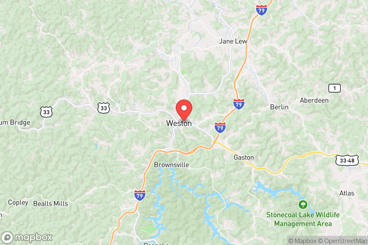
Strategic Assessment of Weston, WV
Meaningful friction. Expect exposure to either population pressure, blast zones, or natural disaster risk. Consider buying a retreat property.
What does the Strategic Assessment tell us?
Our Strategic Assessment grades tactical survivability of an area. Major population centers, military targets, fallout zones, natural disasters, and border exposure all drive risk — lower exposure means a more defensible position in a crisis.
This is heavily inspired by Joel Skousen's Strategic Relocation book. Highly recommended you checkout the book ($)What does this tell us?
Our Strategic Assessment grades tactical survivability of an area. Major population centers, military targets, fallout zones, natural disasters, and border exposure all drive risk — lower exposure means a more defensible position in a crisis.
This is heavily inspired by Joel Skousen's Strategic Relocation book. Highly recommended you checkout the book ($)Strategic Pillars

Key Distances
Regional Safe Places
Below is our recommended "safe zones" in West Virginia and the surrounding area based on our strategic heuristics. For most people, it's unrealistic to live in a “safe zone” full-time due to work, family or other personal reasons. They tend to be more rural. However, many of these areas are perfect for second homes and retreat properties that double as a vacation home or even a short-term rental.


Important Note: For informational purposes only. This does not mean nothing bad ever happens in the green zones. Please use common sense. This is based on public data and modeled with AI. We tried to take a conservative approach but mistakes happen. We update this regularly as new information becomes available.
Solar Generator Recommendations
Backup power matters more here than in safer locations. We've picked three solar generators across budgets and capacity tiers — start with the budget unit if you only need a few essentials, or step up if you want to run a fridge and HVAC for days at a time.

Jackery Portable Power Station Explorer 300
Budget OptionPower on the Go: Weighing only 11 lbs, it's convenient to set up and store with book-sized foldable solar panels

BLUETTI Portable Power Station AC180
Designed for both indoor and outdoor scenarios, AC180 is highly capable as it has a robost capacity and continuous output power.

EF ECOFLOW DELTA Pro Ultra Power Station
Upgraded PickEcoFlow DELTA Pro Ultra is a whole-home energy system designed to grow with your family. Integrated with the Smart Home Panel 2, it scales to meet your evolving energy needs — keeping your home powered, intelligent, and secure through every stage of life.
We earn a commission, at no additional cost to you.
Strategic Assessment Analysis
Weston, West Virginia offers a compelling strategic position for those prioritizing resilience and self-sufficiency, sitting in a sweet spot that balances rural isolation with practical access to critical infrastructure. The town's location in Lewis County places it roughly 90 miles south of Pittsburgh and 120 miles west of Washington, D.C., but the surrounding Appalachian terrain and low population density create a natural buffer against the chaos that often accompanies major metropolitan collapse. For the survivalist or prepper, Weston's primary advantage is its position within the Appalachian spine—a region historically resistant to large-scale disruption due to its rugged geography and decentralized population.
Geographic position and natural advantages for long-term security
Weston sits in the foothills of the Allegheny Mountains, a landscape that provides natural defensibility through elevation changes, dense forest cover, and limited road access. The area is crisscrossed by the West Fork River and numerous smaller creeks, offering reliable water sources that are less likely to be compromised by upstream industrial accidents compared to flatter, more developed regions. The surrounding Lewis County is sparsely populated—roughly 16,000 residents spread over 390 square miles—meaning that in a crisis, competition for resources would be far less intense than in suburban sprawl. The nearby Stonewall Jackson Lake and the expansive Monongahela National Forest to the east provide additional buffer zones and potential foraging grounds. For a relocator, this means you can establish a homestead with relative privacy, and the local terrain makes it difficult for large groups to move through undetected. The region's history of coal and timber extraction also means many locals already possess practical skills in mechanical repair, land management, and off-grid living—a cultural asset that can't be bought.
Risks, exposures, and proximity to fallout-relevant landmarks
No location is without vulnerabilities, and Weston's proximity to certain infrastructure requires careful consideration. The most immediate concern is the Weston State Hospital site, a massive abandoned asylum that has been a source of local lore but also represents a potential liability—abandoned structures can attract squatters or become gathering points for desperate populations during a breakdown. More critically, Weston lies within roughly 60 miles of the Fort Martin Power Station and the Harrison Power Station, both coal-fired plants that could become targets or fail during a grid-down scenario. While not a nuclear reactor, a coal plant's collapse could release heavy metals and particulates into the air and water. The Morgantown Industrial Park and Clarksburg's FBI Center are about 45 minutes north, meaning that a major event targeting federal infrastructure could send refugees or secondary effects southward. On the nuclear front, the Beaver Valley Nuclear Power Station in Pennsylvania is roughly 100 miles north—outside the immediate lethal zone but within a plausible fallout plume depending on wind patterns. The Rockefeller Military Reservation near Charleston is about 90 miles southwest, a potential staging ground for federal forces during unrest. For the prepper, these risks are manageable with proper planning—stockpiling potassium iodide, maintaining a good water filtration system, and having a bug-out route east into the Monongahela National Forest if the wind shifts wrong.
Practical resilience for a relocator: food, water, energy, and defensibility
Weston's practical resilience hinges on its agricultural capacity and local supply chains. Lewis County has a strong farming tradition, with ample pastureland and a growing number of small-scale organic operations. The local farmers' market and co-ops provide a foundation for building relationships with producers who can supply meat, eggs, and vegetables without relying on interstate trucking. Water is abundant—the West Fork River is a reliable surface source, and the area's geology supports shallow wells that are less prone to contamination than deeper aquifers in industrial regions. For energy, the surrounding forests offer virtually unlimited firewood, and the region's hilly terrain is suitable for small-scale hydro or solar installations if you have the capital. The town itself has a small but functional hospital (Stonewall Jackson Memorial Hospital) and a county emergency services network, but the real defensive advantage is the limited road network. Major routes like US-33 and US-19 provide access, but they are easily monitored and can be blocked with minimal effort. The local population is generally armed and self-reliant—West Virginia has some of the most permissive gun laws in the country, and the culture of hunting and personal defense is deeply ingrained. For a single individual or family, this means you can integrate into a community that values preparedness without standing out as an outsider. The biggest practical challenge is the lack of immediate bulk suppliers—you'll need to drive to Buckhannon or Clarksburg for major hardware or medical supplies, so maintaining a robust stockpile is essential.
Overall, Weston presents a highly favorable strategic picture for the conservative prepper seeking a balance between isolation and access. The area's natural barriers, water abundance, and cultural alignment with self-reliance make it a strong candidate for a long-term relocation. The primary trade-off is the proximity to regional infrastructure that could become a liability during a major event—but with proper planning, those risks are manageable. For someone looking to escape the volatility of coastal cities and the vulnerability of suburban sprawl, Weston offers a defensible, resource-rich foothold in the Appalachian heartland. The key is to act before the next crisis drives prices up and competition for land intensifies.
* Values derived from national, state, county, city and local statistics and may differ in a specific area. Last updated: 2026-05-01T06:56:29.000Z
Narrative content on this page is AI-generated and may contain mistakes. Verify any details that matter before acting on them.
ReloMaps may earn a commission from affiliate links at no extra cost to you.