
Photo: Wikipedia
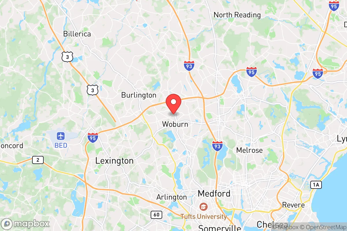
Strategic Assessment of Woburn, MA
Multiple tactical vulnerabilities. Population density, target proximity, or disaster risk are likely compounding. A retreat property and exit planning is required.
What does the Strategic Assessment tell us?
Our Strategic Assessment grades tactical survivability of an area. Major population centers, military targets, fallout zones, natural disasters, and border exposure all drive risk — lower exposure means a more defensible position in a crisis.
This is heavily inspired by Joel Skousen's Strategic Relocation book. Highly recommended you checkout the book ($)What does this tell us?
Our Strategic Assessment grades tactical survivability of an area. Major population centers, military targets, fallout zones, natural disasters, and border exposure all drive risk — lower exposure means a more defensible position in a crisis.
This is heavily inspired by Joel Skousen's Strategic Relocation book. Highly recommended you checkout the book ($)Strategic Pillars

Key Distances
Regional Safe Places
Below is our recommended "safe zones" in Massachusetts and the surrounding area based on our strategic heuristics. For most people, it's unrealistic to live in a “safe zone” full-time due to work, family or other personal reasons. They tend to be more rural. However, many of these areas are perfect for second homes and retreat properties that double as a vacation home or even a short-term rental.


Important Note: For informational purposes only. This does not mean nothing bad ever happens in the green zones. Please use common sense. This is based on public data and modeled with AI. We tried to take a conservative approach but mistakes happen. We update this regularly as new information becomes available.
Solar Generator Recommendations
Backup power matters more here than in safer locations. We've picked three solar generators across budgets and capacity tiers — start with the budget unit if you only need a few essentials, or step up if you want to run a fridge and HVAC for days at a time.

Jackery Portable Power Station Explorer 300
Budget OptionPower on the Go: Weighing only 11 lbs, it's convenient to set up and store with book-sized foldable solar panels

BLUETTI Portable Power Station AC180
Designed for both indoor and outdoor scenarios, AC180 is highly capable as it has a robost capacity and continuous output power.

EF ECOFLOW DELTA Pro Ultra Power Station
Upgraded PickEcoFlow DELTA Pro Ultra is a whole-home energy system designed to grow with your family. Integrated with the Smart Home Panel 2, it scales to meet your evolving energy needs — keeping your home powered, intelligent, and secure through every stage of life.
We earn a commission, at no additional cost to you.
Strategic Assessment Analysis
Woburn, Massachusetts, presents a complex strategic picture for the conservative prepper. Its location 10 miles northwest of Boston offers proximity to economic opportunity, but that same proximity is a major liability in a crisis scenario. The city’s resilience is a mixed bag: solid local infrastructure and a historic industrial base are offset by high population density, vulnerability to coastal fallout, and the inherent risks of being a satellite of a major metropolitan target. For the relocator prioritizing long-term survivability over short-term convenience, Woburn is a location that demands careful, skeptical evaluation.
Geographic position and natural advantages for a survival scenario
Woburn sits on the southern edge of the Middlesex Fells Reservation, a 2,575-acre state park that provides a rare patch of wooded, defensible terrain within the suburban sprawl. This green buffer offers limited but real opportunities for foraging, water collection, and temporary cover. The city is bisected by the Aberjona River, which feeds into the Mystic Lakes, providing a surface water source—though one heavily impacted by industrial runoff from Woburn’s tannery and chemical past. The terrain is gently rolling, with no significant elevation advantages, and the soil is a mix of sandy loam and glacial till, which is marginal for large-scale agriculture without serious amendment. The area’s natural advantages are modest: the Fells offer a retreat zone, but the surrounding suburban matrix of highways (I-93, I-95, Route 128) and dense residential development means any movement off the grid would be quickly observed. The climate is typical New England—cold, wet winters and humid summers—which adds a layer of difficulty for off-grid living without proper shelter and fuel stores.
Risks, exposures, and proximity to fallout-relevant landmarks
The single greatest strategic liability of Woburn is its position within the Boston metropolitan area. In any scenario involving civil unrest, mass casualty events, or a coordinated attack, Boston is a high-probability target. Woburn lies within the blast and fallout radius of several critical infrastructure nodes: Logan International Airport (12 miles southeast), the Port of Boston, and the region’s major power substations and fuel depots along the I-95 corridor. The city itself hosts a major rail line (the MBTA Lowell Line) and is adjacent to the Hanscom Air Force Base (6 miles west), a facility that, while primarily a research and airfield hub, could become a secondary target or a point of military activity. The concentration of pharmaceutical and biotech firms in the Woburn area—including large facilities for companies like Pfizer and Sanofi—adds a secondary risk: these sites could be targets for industrial sabotage or become sources of hazardous material release during a disaster. The city’s population density of roughly 2,200 people per square mile means that any evacuation route (primarily I-93 and Route 128) would become a choke point within minutes of a crisis. For the prepper, Woburn’s proximity to these landmarks is a net negative, placing it in a zone of high risk for both direct effects and secondary chaos.
Practical resilience for a relocator: food, water, energy, and defensibility
Woburn’s practical resilience is underwhelming for a serious prepper. The municipal water supply comes from the Massachusetts Water Resources Authority (MWRA) system, which draws from the Quabbin and Wachusett Reservoirs—a robust source, but one that is vulnerable to contamination, sabotage, or systemic failure in a prolonged crisis. A private well is possible in some older neighborhoods, but the city’s industrial history has left a legacy of groundwater contamination (the infamous Woburn wells case involving trichloroethylene and tetrachloroethylene), meaning any well water must be tested and filtered aggressively. Food security is poor: the city has no significant agricultural base, and the nearest large-scale farmland is in the Merrimack Valley, 20+ miles north. The Woburn Farmers Market is a weekly event, not a survival resource. Energy infrastructure is tied to the regional grid, with no local power generation of note; a solar setup with battery storage is feasible on a single-family lot, but the dense tree canopy and zoning restrictions limit options. Defensibility is the weakest point. Woburn is a suburban grid of interconnected streets, with no natural chokepoints, limited high ground, and a police force of roughly 80 officers for a population of 40,000. In a collapse scenario, the city would be a sieve—easy to enter, hard to secure, and full of potential looters from the nearby urban core. The best a relocator could do is secure a property on the edge of the Fells, with a reinforced perimeter, a deep well, and a year’s worth of stored supplies. Even then, the noise and light signature of a prepared home would attract attention in a dense neighborhood.
The overall strategic picture for Woburn is one of calculated risk with a low ceiling for long-term survivability. It offers the prepper a foothold near economic opportunity and a sliver of green space, but the liabilities of population density, industrial contamination, and proximity to a major target city outweigh the benefits for anyone serious about riding out a systemic crisis. For the conservative relocator who values community and local governance, Woburn’s municipal structure is functional but not exceptional—the city has a strong-mayor system and a moderate tax base, but it lacks the independent infrastructure (local food production, redundant water sources, defensible geography) that makes a location truly resilient. If your strategy is to be close enough to Boston to work but far enough to survive a short-term disruption, Woburn might work. If you’re planning for a multi-year collapse, look further north or west, where the population thins and the land offers more than a park and a polluted river. Woburn is a place to pass through, not to dig in.
* Values derived from national, state, county, city and local statistics and may differ in a specific area. Last updated: 2026-05-01T10:25:36.000Z
Narrative content on this page is AI-generated and may contain mistakes. Verify any details that matter before acting on them.
ReloMaps may earn a commission from affiliate links at no extra cost to you.