Photo: Wikipedia
Strategic Assessment of Woodstock, VT
Meaningful friction. Expect exposure to either population pressure, blast zones, or natural disaster risk. Consider buying a retreat property.
What does the Strategic Assessment tell us?
Our Strategic Assessment grades tactical survivability of an area. Major population centers, military targets, fallout zones, natural disasters, and border exposure all drive risk — lower exposure means a more defensible position in a crisis.
This is heavily inspired by Joel Skousen's Strategic Relocation book. Highly recommended you checkout the book ($)What does this tell us?
Our Strategic Assessment grades tactical survivability of an area. Major population centers, military targets, fallout zones, natural disasters, and border exposure all drive risk — lower exposure means a more defensible position in a crisis.
This is heavily inspired by Joel Skousen's Strategic Relocation book. Highly recommended you checkout the book ($)Strategic Pillars

Key Distances
Regional Safe Places
Below is our recommended "safe zones" in Vermont and the surrounding area based on our strategic heuristics. For most people, it's unrealistic to live in a “safe zone” full-time due to work, family or other personal reasons. They tend to be more rural. However, many of these areas are perfect for second homes and retreat properties that double as a vacation home or even a short-term rental.


Important Note: For informational purposes only. This does not mean nothing bad ever happens in the green zones. Please use common sense. This is based on public data and modeled with AI. We tried to take a conservative approach but mistakes happen. We update this regularly as new information becomes available.
Solar Generator Recommendations
Backup power matters more here than in safer locations. We've picked three solar generators across budgets and capacity tiers — start with the budget unit if you only need a few essentials, or step up if you want to run a fridge and HVAC for days at a time.

Jackery Portable Power Station Explorer 300
Budget OptionPower on the Go: Weighing only 11 lbs, it's convenient to set up and store with book-sized foldable solar panels

BLUETTI Portable Power Station AC180
Designed for both indoor and outdoor scenarios, AC180 is highly capable as it has a robost capacity and continuous output power.

EF ECOFLOW DELTA Pro Ultra Power Station
Upgraded PickEcoFlow DELTA Pro Ultra is a whole-home energy system designed to grow with your family. Integrated with the Smart Home Panel 2, it scales to meet your evolving energy needs — keeping your home powered, intelligent, and secure through every stage of life.
We earn a commission, at no additional cost to you.
Strategic Assessment Analysis
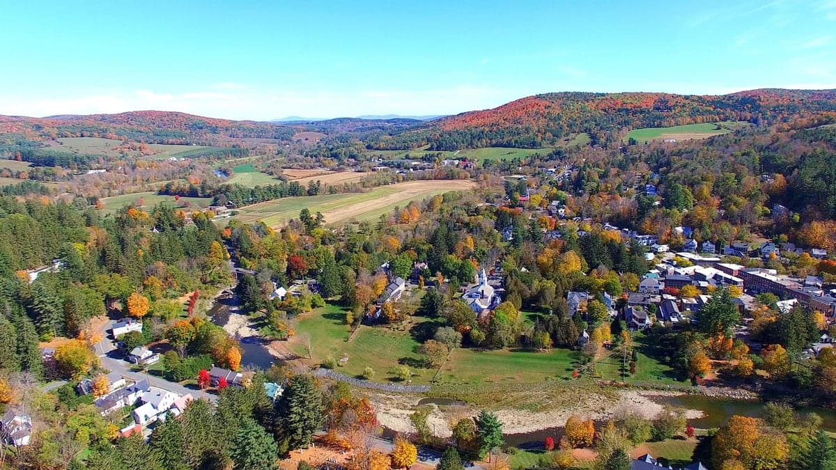
Woodstock, Vermont, presents a mixed strategic picture for the conservative prepper: it offers genuine natural resilience and a strong community fabric, but its location in the Northeast and proximity to high-value targets create significant vulnerabilities that demand careful, sober assessment. The town sits in a valley carved by the Ottauquechee River, surrounded by the Green Mountains, which provide a natural buffer against the chaos of the Eastern Seaboard. While the area’s charm and tourist economy are well-known, the underlying geography and infrastructure offer a foundation for a low-profile, self-sufficient lifestyle—if you’re willing to accept the trade-offs of being in a state with restrictive gun laws and a liberal political climate. For the relocator prioritizing strategic depth over convenience, Woodstock is a location that requires active mitigation, not passive safety.
Geographic position and natural advantages for a low-profile relocation
Woodstock’s primary strategic asset is its position within a natural fortress. The town is nestled in a valley at roughly 700 feet elevation, with the Green Mountain National Forest to the west and the White Mountains of New Hampshire to the east. This terrain creates a natural funnel for travel—only a few major roads (US-4, VT-12, and VT-106) lead in and out, making chokepoint defense feasible for a prepared group. The surrounding hills are heavily forested, offering ample cover and concealment for caches, retreats, or observation posts. The Ottauquechee River runs through the center of town, providing a reliable surface water source, though it is not large enough for significant navigation—a plus for privacy. The area’s low population density (Windsor County has about 55 people per square mile) means fewer eyes and less competition for resources in a crisis. The climate is four-season, with cold winters that naturally deter transient populations and force residents to develop serious cold-weather skills. For the prepper, this is a location that rewards preparation and punishes complacency.
Risks, exposures, and proximity to fallout-relevant landmarks
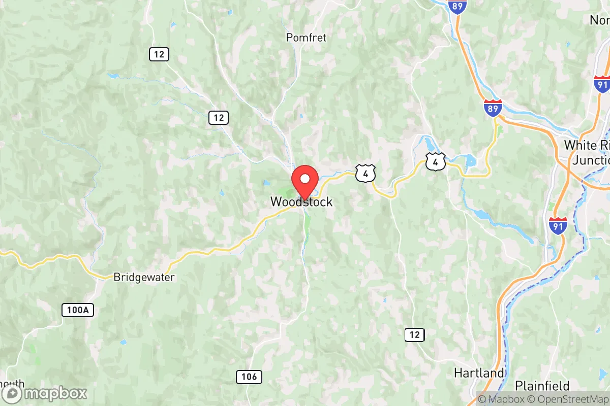
The most glaring vulnerability for Woodstock is its proximity to high-value targets along the I-91 and I-89 corridors. The town is roughly 30 miles from the Vermont Yankee nuclear power plant in Vernon (now decommissioned but still storing spent fuel), and about 60 miles from the Seabrook Station nuclear plant in New Hampshire. In a major event, prevailing winds from the southwest could carry fallout directly over the valley. Additionally, Woodstock sits only 12 miles from the Quechee Gorge area, a tourist hub that could become a chokepoint for refugees fleeing the Boston-New York corridor. The town itself is a tourist destination, meaning its population swells seasonally, and the local economy is heavily dependent on visitors—a fragility that could collapse overnight in a crisis. The nearest major city, Burlington (population ~45,000), is 90 miles north, but the real threat is the Boston-Washington megalopolis, which is within a 4-5 hour drive. In a societal breakdown, Woodstock would likely see a wave of displaced people from the coast. The town’s police force is small (under 10 officers), and the Windsor County Sheriff’s office is stretched thin. For the conservative relocator, this means self-reliance is not optional—it is the only viable strategy.
Practical resilience for a relocator: food, water, energy, and defensibility
Woodstock’s practical resilience is a mixed bag. On the positive side, the area has abundant surface water: the Ottauquechee River, plus numerous streams and ponds in the surrounding national forest. Groundwater is generally accessible via wells, but many homes in the historic district rely on municipal water from the town’s reservoir on Mount Tom. In a grid-down scenario, that reservoir is a single point of failure. The local soil is rocky but workable; small-scale gardening is feasible with raised beds or greenhouses, but the short growing season (roughly 120 days) limits staple crops. The surrounding forests offer game—white-tailed deer, turkey, and small game—but overhunting would be a risk in a prolonged crisis. Firewood is abundant, but the town’s strict historic district regulations could complicate large-scale wood storage or alternative energy installations. Solar is viable but limited by winter cloud cover; a well-designed off-grid system with battery storage and a backup generator is essential. Defensibility is moderate: the valley floor is open, but the surrounding hills provide excellent observation points. The town’s layout—a compact village center with scattered rural homes—means that a small, organized group could secure a perimeter around a single property, but defending the entire town is impractical. The local hospital, Dartmouth-Hitchcock Medical Center in Lebanon, NH (30 miles away), is a major asset, but it would be overwhelmed in a mass casualty event. For the prepper, the key is to establish a self-sufficient homestead outside the village core, with a well, solar array, wood heat, and a defensible position on high ground.
The overall strategic picture for Woodstock is one of cautious opportunity. The natural geography offers genuine advantages—terrain, water, and isolation from the worst of the coastal chaos—but the risks are real and require active management. The town’s liberal political climate and restrictive state laws (magazine capacity limits, a 10-round handgun limit, and a permit-to-purchase system) mean that the conservative relocator must be discreet and legally compliant, or consider a neighboring state like New Hampshire for a more firearms-friendly base. The proximity to nuclear sites and the tourist economy’s fragility are non-negotiable liabilities. For the single individual or family willing to invest in serious preparation—off-grid infrastructure, food storage, security planning, and community building with like-minded locals—Woodstock can be a viable long-term redoubt. But it is not a place for the unprepared or the passive. It is a location that demands you bring your own resilience, because the environment will not provide it for you. If you are looking for a low-risk, turnkey survival location, look elsewhere. If you are willing to work for your security, Woodstock offers a foundation worth building on.
* Values derived from national, state, county, city and local statistics and may differ in a specific area. Last updated: 2026-04-30T14:34:09.000Z
Narrative content on this page is AI-generated and may contain mistakes. Verify any details that matter before acting on them.
ReloMaps may earn a commission from affiliate links at no extra cost to you.