Photo: Wikipedia
Strategic Assessment of Annapolis, MD
Multiple tactical vulnerabilities. Population density, target proximity, or disaster risk are likely compounding. A retreat property and exit planning is required.
What does the Strategic Assessment tell us?
Our Strategic Assessment grades tactical survivability of an area. Major population centers, military targets, fallout zones, natural disasters, and border exposure all drive risk — lower exposure means a more defensible position in a crisis.
This is heavily inspired by Joel Skousen's Strategic Relocation book. Highly recommended you checkout the book ($)What does this tell us?
Our Strategic Assessment grades tactical survivability of an area. Major population centers, military targets, fallout zones, natural disasters, and border exposure all drive risk — lower exposure means a more defensible position in a crisis.
This is heavily inspired by Joel Skousen's Strategic Relocation book. Highly recommended you checkout the book ($)Strategic Pillars

Key Distances
Regional Safe Places
Below is our recommended "safe zones" in Maryland and the surrounding area based on our strategic heuristics. For most people, it's unrealistic to live in a “safe zone” full-time due to work, family or other personal reasons. They tend to be more rural. However, many of these areas are perfect for second homes and retreat properties that double as a vacation home or even a short-term rental.


Important Note: For informational purposes only. This does not mean nothing bad ever happens in the green zones. Please use common sense. This is based on public data and modeled with AI. We tried to take a conservative approach but mistakes happen. We update this regularly as new information becomes available.
Solar Generator Recommendations
Backup power matters more here than in safer locations. We've picked three solar generators across budgets and capacity tiers — start with the budget unit if you only need a few essentials, or step up if you want to run a fridge and HVAC for days at a time.

Jackery Portable Power Station Explorer 300
Budget OptionPower on the Go: Weighing only 11 lbs, it's convenient to set up and store with book-sized foldable solar panels

BLUETTI Portable Power Station AC180
Designed for both indoor and outdoor scenarios, AC180 is highly capable as it has a robost capacity and continuous output power.

EF ECOFLOW DELTA Pro Ultra Power Station
Upgraded PickEcoFlow DELTA Pro Ultra is a whole-home energy system designed to grow with your family. Integrated with the Smart Home Panel 2, it scales to meet your evolving energy needs — keeping your home powered, intelligent, and secure through every stage of life.
We earn a commission, at no additional cost to you.
Strategic Assessment Analysis
Annapolis, Maryland, presents a mixed strategic picture for the conservative prepper or survivalist. While its position on the Chesapeake Bay offers some natural advantages for resource independence and water access, its proximity to the Washington D.C. and Baltimore metro areas introduces severe vulnerabilities that cannot be ignored. The city’s role as the state capital and a hub for naval operations makes it a potential target during civil unrest or a mass casualty event, yet its relative isolation on a peninsula and strong local community networks offer a degree of defensibility that many suburban areas lack. For the relocator weighing long-term resilience, Annapolis is a high-risk, moderate-reward location that demands careful planning and a clear-eyed assessment of its exposure to fallout from larger regional crises.
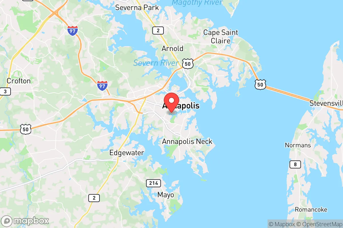
Geographic position and natural advantages for long-term survival
Annapolis sits on the Severn River at its mouth on the Chesapeake Bay, giving it a unique geographic profile. The city is effectively on a peninsula, bounded by water on three sides, which naturally limits access points and creates a chokepoint for any potential ground-based threat. This water-bounded layout can be a defensive asset during civil unrest, as the number of road bridges and routes into the city is finite and easily monitored. The Chesapeake Bay itself provides a massive, renewable source of water—though it is brackish and requires desalination or advanced filtration for drinking—and a rich ecosystem for fishing, crabbing, and foraging. The surrounding Anne Arundel County has a mix of forested areas, farmland, and tidal marshes, offering opportunities for hunting, trapping, and small-scale agriculture. The region’s temperate climate means four distinct seasons, which supports year-round food production in greenhouses or cold frames, and the moderate rainfall reduces the risk of prolonged drought compared to more arid parts of the country. For a relocator with a prepper mindset, the ability to access the bay for protein and the presence of defensible terrain are genuine pluses, but they come with strings attached.
Risks, exposures, and proximity to fallout-relevant landmarks
The single biggest strategic liability for Annapolis is its location within the Washington-Baltimore combined statistical area. Annapolis is roughly 30 miles from the White House and 25 miles from the Pentagon, placing it well within the blast radius of a nuclear detonation at either target, and certainly within the fallout zone. The city is also home to the United States Naval Academy, a high-value military installation that would be a primary target in any major conflict. During a mass casualty event or widespread civil unrest, Annapolis would likely see a massive influx of refugees from D.C. and Baltimore, overwhelming local resources and infrastructure. The only major evacuation routes are US-50 and MD-2, both of which become parking lots during rush hour and would be completely gridlocked in a crisis. The Chesapeake Bay Bridge, a critical link to the Eastern Shore, is a single point of failure that could be compromised by an accident, attack, or simply by panic traffic. Additionally, the city’s low-lying coastal geography makes it vulnerable to storm surge from hurricanes and nor’easters, which could flood large portions of downtown and the Naval Academy. For the survivalist, the concentration of political and military targets nearby, combined with the city’s limited egress, makes Annapolis a high-risk location for any scenario involving a coordinated attack or societal collapse.
Practical resilience for a relocator: food, water, energy, and defensibility
On the practical side, Annapolis offers some genuine resilience advantages if you can mitigate the proximity risks. Water access is the strongest asset: the Severn River and Chesapeake Bay provide an essentially unlimited supply for non-potable uses, and with a good reverse osmosis system or distillation setup, you can produce drinking water indefinitely. The bay’s blue crab, rockfish, and oyster populations are robust, and fishing regulations are generally lax for personal consumption, making it a reliable protein source. For energy, the region has decent solar potential—about 4.5 peak sun hours per day—and many homes in the area have enough roof space for a modest off-grid solar array. Wood heating is viable given the surrounding forests, but you’ll need to secure a supply chain or harvest your own. Food production is possible on small plots, but the soil in much of Anne Arundel County is sandy and acidic, requiring amendment for serious gardening. Community gardens and local farmers’ markets exist, but they are not a substitute for a personal food stockpile. Defensibility is a mixed bag: the peninsula layout limits approach routes, but the city itself is dense and has many choke points that could be exploited by hostile groups. A better strategy for a relocator might be to buy property just outside the city limits—say, in the Crownsville or Davidsonville areas—where you get more land, better soil, and a lower population density while still being close enough to the bay for water access. Overall, Annapolis scores well on water and moderate on food and energy, but poorly on defensibility and egress.
The overall strategic picture for the conservative prepper
Annapolis is not a bug-out location. It is not a remote retreat where you can ride out a collapse in isolation. Instead, it is a high-risk, high-reward position for someone who wants to stay engaged with the broader world while maintaining a degree of self-sufficiency. The city’s water access, temperate climate, and limited road access give it a foundation for resilience, but the proximity to D.C. and Baltimore, the presence of the Naval Academy, and the vulnerability to storm surge make it a target-rich environment for any major disaster. For a single individual or a family with a conservative, preparedness-oriented mindset, the smart play is to treat Annapolis as a base of operations rather than a final redoubt. Stockpile supplies for at least 90 days, invest in water filtration and solar power, and have a secondary retreat location inland—perhaps in western Maryland or West Virginia—that you can reach via back roads if the bridges are blocked. The city’s strategic value lies in its resources and community, but only if you are willing to accept the risks that come with being in the shadow of the nation’s capital. If you can handle that trade-off, Annapolis offers a unique blend of opportunity and danger that few other East Coast locations can match.
* Values derived from national, state, county, city and local statistics and may differ in a specific area. Last updated: 2026-04-29T23:21:38.000Z
Narrative content on this page is AI-generated and may contain mistakes. Verify any details that matter before acting on them.
ReloMaps may earn a commission from affiliate links at no extra cost to you.