Photo: Wikipedia
Strategic Assessment of Bantam, CT
Multiple tactical vulnerabilities. Population density, target proximity, or disaster risk are likely compounding. A retreat property and exit planning is required.
What does the Strategic Assessment tell us?
Our Strategic Assessment grades tactical survivability of an area. Major population centers, military targets, fallout zones, natural disasters, and border exposure all drive risk — lower exposure means a more defensible position in a crisis.
This is heavily inspired by Joel Skousen's Strategic Relocation book. Highly recommended you checkout the book ($)What does this tell us?
Our Strategic Assessment grades tactical survivability of an area. Major population centers, military targets, fallout zones, natural disasters, and border exposure all drive risk — lower exposure means a more defensible position in a crisis.
This is heavily inspired by Joel Skousen's Strategic Relocation book. Highly recommended you checkout the book ($)Strategic Pillars

Key Distances
Regional Safe Places
Below is our recommended "safe zones" in Connecticut and the surrounding area based on our strategic heuristics. For most people, it's unrealistic to live in a “safe zone” full-time due to work, family or other personal reasons. They tend to be more rural. However, many of these areas are perfect for second homes and retreat properties that double as a vacation home or even a short-term rental.


Important Note: For informational purposes only. This does not mean nothing bad ever happens in the green zones. Please use common sense. This is based on public data and modeled with AI. We tried to take a conservative approach but mistakes happen. We update this regularly as new information becomes available.
Solar Generator Recommendations
Backup power matters more here than in safer locations. We've picked three solar generators across budgets and capacity tiers — start with the budget unit if you only need a few essentials, or step up if you want to run a fridge and HVAC for days at a time.

Jackery Portable Power Station Explorer 300
Budget OptionPower on the Go: Weighing only 11 lbs, it's convenient to set up and store with book-sized foldable solar panels

BLUETTI Portable Power Station AC180
Designed for both indoor and outdoor scenarios, AC180 is highly capable as it has a robost capacity and continuous output power.

EF ECOFLOW DELTA Pro Ultra Power Station
Upgraded PickEcoFlow DELTA Pro Ultra is a whole-home energy system designed to grow with your family. Integrated with the Smart Home Panel 2, it scales to meet your evolving energy needs — keeping your home powered, intelligent, and secure through every stage of life.
We earn a commission, at no additional cost to you.
Strategic Assessment Analysis
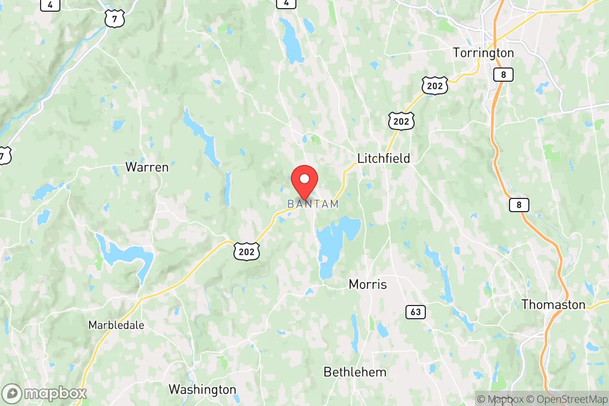
Bantam, Connecticut, offers a surprisingly resilient strategic position for those prioritizing preparedness and self-sufficiency, sitting in the Litchfield Hills roughly 30 miles from Hartford and 90 miles from New York City. This small borough of roughly 750 people is tucked into a rural pocket of northwestern Connecticut, providing a buffer from the immediate fallout of urban collapse while remaining close enough to access critical resources if supply chains hold. For a relocator with a prepper mindset, Bantam’s low population density, natural terrain, and distance from major infrastructure targets make it a viable base for weathering civic unrest, mass casualty events, or large-scale disasters.
Geographic position and natural defensive advantages
Bantam sits within the Litchfield Hills, a region of rolling ridges, hardwood forests, and scattered lakes that offer natural cover and defensibility. The borough is located on Bantam Lake, the largest natural lake in Connecticut, which provides a reliable freshwater source for drinking, irrigation, and firefighting—a critical asset in grid-down scenarios. The surrounding terrain is hilly and wooded, with limited through-roads, which naturally slows movement and makes the area harder to approach or surveil. Bantam is roughly 15 miles from the Appalachian Trail corridor, offering potential escape routes or resupply paths into less populated areas of Massachusetts and New York. The nearest interstate, I-84, is about 20 miles south, meaning major evacuation or military traffic is unlikely to pass directly through the borough. This geographic isolation, combined with a year-round water source and defensible topography, gives Bantam a strong baseline for long-term survival compared to flatter, more exposed parts of the state.
Risks, exposures, and proximity to fallout-relevant landmarks
No location is without risk, and Bantam’s proximity to several high-value targets is a serious consideration. The borough lies roughly 25 miles from the Millstone Nuclear Power Station in Waterford, a potential target for sabotage or accident that could produce a radioactive plume affecting the Litchfield Hills depending on wind patterns. Additionally, Bantam is within 30 miles of Bradley International Airport in Windsor Locks, a major cargo and military transport hub that could become a staging area during federal emergencies or a target for civil unrest. The New York City metropolitan area, 90 miles south, is a primary concern for mass evacuation flows; in a collapse scenario, refugees from the city could push north along Route 8 and Route 7, both of which pass within 10 miles of Bantam. The borough itself has no major industrial or government facilities, which reduces its likelihood of being directly targeted, but its proximity to these landmarks means a relocator must plan for secondary effects like radiation drift, refugee influx, or supply chain disruption. The risk is moderate but manageable with proper preparation—specifically, having a radiation detection kit, a vehicle capable of off-road travel, and a pre-planned secondary retreat deeper into the Berkshires if conditions deteriorate.
Practical resilience for a relocator: food, water, energy, and defensibility
Bantam’s practical resilience hinges on its natural resources and the ability to establish self-sufficiency before a crisis. The borough’s location on Bantam Lake means water is abundant, but it requires treatment—boiling, filtration, or chemical purification—since the lake is used for recreation and has potential contamination from runoff. The surrounding forests support deer, turkey, and small game, and the area has a history of small-scale agriculture, with several farms within a 10-mile radius selling produce, eggs, and meat. For energy, the region’s tree cover provides ample firewood, and the hilly terrain is suitable for small-scale hydro or solar if a property has southern exposure. The borough’s small population and tight-knit community culture mean that neighbors are likely to know each other, which can be a double-edged sword: trust is easier to build, but outsiders are quickly noticed. Defensibility is strong due to the limited road access—Route 209 is the main artery, and it narrows to two lanes with choke points at bridges over the Bantam River. A small group could monitor or block these approaches with minimal effort. However, the borough has no local police department (state police cover the area), so security during a breakdown would rely entirely on resident cooperation and personal preparedness. Relocators should prioritize a property with a well or lake access, a wood stove or generator, and a defensible perimeter—ideally on a dead-end road or cul-de-sac.
The overall strategic picture for Bantam as a relocation base
Bantam presents a balanced strategic option for the conservative prepper who wants to stay within a few hours of the Northeast corridor but avoid the immediate blast zone of urban collapse. Its natural water source, defensible terrain, and low profile make it a strong candidate for a primary retreat, provided the relocator is willing to invest in off-grid infrastructure and build local relationships before a crisis. The main trade-off is proximity to high-value targets like the Millstone nuclear plant and Bradley Airport, which introduce moderate fallout and evacuation risks that require active mitigation. For a single individual or family willing to stockpile supplies, learn basic wilderness skills, and maintain a low social profile, Bantam offers a realistic base for riding out the worst of what’s coming—without the extreme isolation of a mountain cabin in Montana. The key is to act now, while the area remains affordable and the community is still stable, because once the balloon goes up, every patch of woods within 100 miles of New York will be contested ground.
* Values derived from national, state, county, city and local statistics and may differ in a specific area. Last updated: 2026-04-30T00:35:56.000Z
Narrative content on this page is AI-generated and may contain mistakes. Verify any details that matter before acting on them.
ReloMaps may earn a commission from affiliate links at no extra cost to you.