Photo: Wikipedia
Strategic Assessment of Barton, VT
Meaningful friction. Expect exposure to either population pressure, blast zones, or natural disaster risk. Consider buying a retreat property.
What does the Strategic Assessment tell us?
Our Strategic Assessment grades tactical survivability of an area. Major population centers, military targets, fallout zones, natural disasters, and border exposure all drive risk — lower exposure means a more defensible position in a crisis.
This is heavily inspired by Joel Skousen's Strategic Relocation book. Highly recommended you checkout the book ($)What does this tell us?
Our Strategic Assessment grades tactical survivability of an area. Major population centers, military targets, fallout zones, natural disasters, and border exposure all drive risk — lower exposure means a more defensible position in a crisis.
This is heavily inspired by Joel Skousen's Strategic Relocation book. Highly recommended you checkout the book ($)Strategic Pillars

Key Distances
Regional Safe Places
Below is our recommended "safe zones" in Vermont and the surrounding area based on our strategic heuristics. For most people, it's unrealistic to live in a “safe zone” full-time due to work, family or other personal reasons. They tend to be more rural. However, many of these areas are perfect for second homes and retreat properties that double as a vacation home or even a short-term rental.


Important Note: For informational purposes only. This does not mean nothing bad ever happens in the green zones. Please use common sense. This is based on public data and modeled with AI. We tried to take a conservative approach but mistakes happen. We update this regularly as new information becomes available.
Solar Generator Recommendations
Backup power matters more here than in safer locations. We've picked three solar generators across budgets and capacity tiers — start with the budget unit if you only need a few essentials, or step up if you want to run a fridge and HVAC for days at a time.

Jackery Portable Power Station Explorer 300
Budget OptionPower on the Go: Weighing only 11 lbs, it's convenient to set up and store with book-sized foldable solar panels

BLUETTI Portable Power Station AC180
Designed for both indoor and outdoor scenarios, AC180 is highly capable as it has a robost capacity and continuous output power.

EF ECOFLOW DELTA Pro Ultra Power Station
Upgraded PickEcoFlow DELTA Pro Ultra is a whole-home energy system designed to grow with your family. Integrated with the Smart Home Panel 2, it scales to meet your evolving energy needs — keeping your home powered, intelligent, and secure through every stage of life.
We earn a commission, at no additional cost to you.
Strategic Assessment Analysis
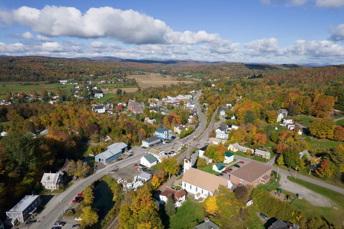
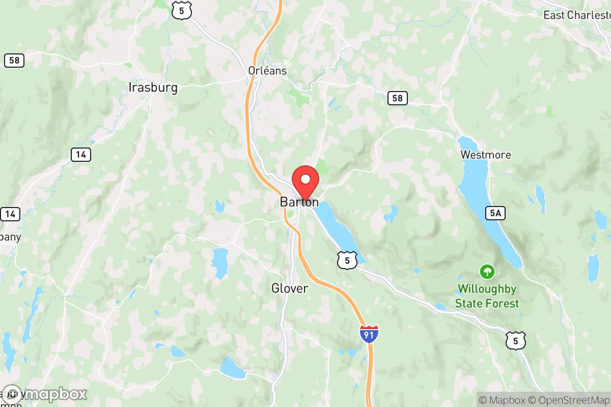
Barton, Vermont, offers a compelling strategic position for those prioritizing long-term resilience, sitting in the remote Northeast Kingdom where the population density is among the lowest in the eastern United States. With fewer than 800 residents in the village proper and Orleans County averaging just 38 people per square mile, the area provides natural buffering from the cascading effects of urban unrest and infrastructure collapse. Its location roughly 50 miles from the Canadian border and 90 miles from Montreal creates a secondary egress corridor, while the surrounding landscape of working forests, small farms, and scattered hamlets makes it a hard target for any large-scale disruption originating from the Boston-to-Washington corridor.
Geographic position and natural advantages for long-term security
Barton sits at the intersection of several natural features that enhance its strategic value. The Barton River runs through the village, feeding into Lake Memphremagog to the north, and the area is ringed by the Green Mountains and the granite ridges of the Northeast Kingdom. This topography creates natural chokepoints on the few roads entering the region—primarily US-5 and VT-16—which could be monitored or controlled if needed. The surrounding Caledonia and Orleans counties are heavily forested, with over 80% of the land classified as timberland, providing ample cover, fuel, and raw materials for those with basic woodcraft skills. The growing season is short (roughly 100–120 days), but the region's legacy as a dairy and maple-producing area means the soil is workable for small-scale agriculture, and the abundant surface water from streams, ponds, and the Barton River itself offers a reliable off-grid water source. For a relocator thinking in terms of decades, not years, the combination of low population, defensible terrain, and renewable resources is hard to beat east of the Mississippi.
Risks, exposures, and proximity to fallout-relevant landmarks
No location is without vulnerabilities, and Barton has several that a serious prepper must weigh. The most immediate concern is the area's proximity to the Jay Peak and Newport corridor, which sees seasonal tourist traffic and could become a chokepoint for displaced populations heading north from the I-89 corridor. Burlington, Vermont's largest city, lies about 75 miles to the southwest—close enough that a major event there (civil unrest, disease outbreak, or infrastructure failure) could send refugees up US-5 and VT-16 within 24–48 hours. The Canadian border at Derby Line is roughly 25 miles north; while this offers an escape route, it also means potential border closures, customs disruptions, or security checkpoints that could complicate movement. More critically, Barton sits within 150 miles of the Vermont Yankee nuclear site (now decommissioned but still holding spent fuel) and roughly 200 miles from the Seabrook Station nuclear plant in New Hampshire. In a worst-case scenario involving a radiological release, prevailing winds from the southwest could carry fallout into the Northeast Kingdom, though the mountainous terrain would provide some shielding. The area also experiences harsh winters—average January lows around 5°F, with annual snowfall exceeding 80 inches—which can be a double-edged sword: it deters transient populations but also creates serious survival challenges for the unprepared. Power outages lasting a week or more are common during ice storms, and the local grid is fragile, with many overhead lines running through remote stretches of forest.
Practical resilience for a relocator: food, water, energy, and defensibility
For a single individual or family looking to establish a resilient homestead, Barton's practical assets are significant but require upfront investment. The local water table is high, and shallow wells are common, but testing for agricultural runoff and naturally occurring arsenic is essential—about 20% of private wells in Orleans County exceed the EPA's recommended arsenic limit. Surface water from the Barton River and nearby Lake Willoughby (10 miles south) is abundant, but filtration and boiling protocols are a must due to beaver activity and agricultural runoff. Food security is the region's strongest suit: the Northeast Kingdom has a robust network of small farms, CSAs, and farmers' markets, with the Barton Farmers Market operating seasonally. The area's dairy heritage means raw milk access is relatively straightforward through herd-share agreements, and the maple syrup industry provides a calorie-dense, shelf-stable sweetener that can also be traded. Hunting and fishing are excellent—white-tailed deer, black bear, wild turkey, and brook trout are all abundant, and Vermont's liberal hunting laws allow for year-round take of certain species with proper licensing. For energy, the region's forest biomass is the most practical off-grid heating source; wood stoves are standard in nearly every rural home, and firewood permits on state land are cheap and accessible. Solar potential is moderate—the area gets about 160 sunny days per year, below the national average—but with battery storage and a backup generator, a well-designed system can cover basic loads. Defensibility is high: the village itself is compact, with a few main roads and a river cutting through it, but the surrounding countryside offers numerous remote properties with long, single-access driveways and natural screening from the road. The local culture leans heavily toward self-reliance and mutual aid—neighbors help each other with haying, logging, and snow removal—but outsiders should expect a long probationary period before being fully trusted. The Orleans County Sheriff's Office covers the area, but response times in the backcountry can exceed 30 minutes, so personal security and medical preparedness are non-negotiable.
The overall strategic picture for Barton is one of high potential paired with real trade-offs. It offers one of the best combinations of low population density, natural resources, and geographic isolation available in the northeastern United States, making it a strong candidate for anyone serious about weathering a prolonged disruption. The trade-offs are the harsh winters, the modest but real risk of fallout from distant nuclear sites, and the possibility of transient pressure from the Burlington and Montreal corridors during a crisis. For a conservative-minded relocator who values community cohesion, self-sufficiency, and the ability to live without constant dependence on fragile supply chains, Barton represents a solid, if not perfect, bet. The key is to arrive with skills, supplies, and a willingness to integrate—because in a place this remote, your neighbors are your first line of defense, and your own preparation is your last.
* Values derived from national, state, county, city and local statistics and may differ in a specific area. Last updated: 2026-04-30T13:57:35.000Z
Narrative content on this page is AI-generated and may contain mistakes. Verify any details that matter before acting on them.
ReloMaps may earn a commission from affiliate links at no extra cost to you.