Photo: Wikipedia
Strategic Assessment of Bellows Falls, VT
Meaningful friction. Expect exposure to either population pressure, blast zones, or natural disaster risk. Consider buying a retreat property.
What does the Strategic Assessment tell us?
Our Strategic Assessment grades tactical survivability of an area. Major population centers, military targets, fallout zones, natural disasters, and border exposure all drive risk — lower exposure means a more defensible position in a crisis.
This is heavily inspired by Joel Skousen's Strategic Relocation book. Highly recommended you checkout the book ($)What does this tell us?
Our Strategic Assessment grades tactical survivability of an area. Major population centers, military targets, fallout zones, natural disasters, and border exposure all drive risk — lower exposure means a more defensible position in a crisis.
This is heavily inspired by Joel Skousen's Strategic Relocation book. Highly recommended you checkout the book ($)Strategic Pillars

Key Distances
Regional Safe Places
Below is our recommended "safe zones" in Vermont and the surrounding area based on our strategic heuristics. For most people, it's unrealistic to live in a “safe zone” full-time due to work, family or other personal reasons. They tend to be more rural. However, many of these areas are perfect for second homes and retreat properties that double as a vacation home or even a short-term rental.


Important Note: For informational purposes only. This does not mean nothing bad ever happens in the green zones. Please use common sense. This is based on public data and modeled with AI. We tried to take a conservative approach but mistakes happen. We update this regularly as new information becomes available.
Solar Generator Recommendations
Backup power matters more here than in safer locations. We've picked three solar generators across budgets and capacity tiers — start with the budget unit if you only need a few essentials, or step up if you want to run a fridge and HVAC for days at a time.

Jackery Portable Power Station Explorer 300
Budget OptionPower on the Go: Weighing only 11 lbs, it's convenient to set up and store with book-sized foldable solar panels

BLUETTI Portable Power Station AC180
Designed for both indoor and outdoor scenarios, AC180 is highly capable as it has a robost capacity and continuous output power.

EF ECOFLOW DELTA Pro Ultra Power Station
Upgraded PickEcoFlow DELTA Pro Ultra is a whole-home energy system designed to grow with your family. Integrated with the Smart Home Panel 2, it scales to meet your evolving energy needs — keeping your home powered, intelligent, and secure through every stage of life.
We earn a commission, at no additional cost to you.
Strategic Assessment Analysis
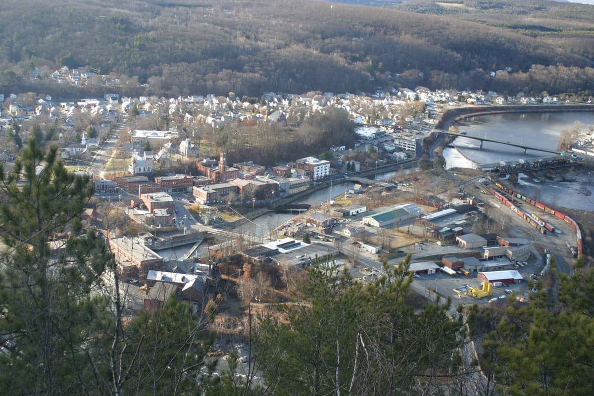
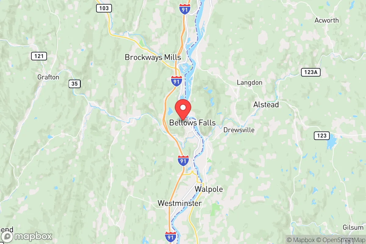
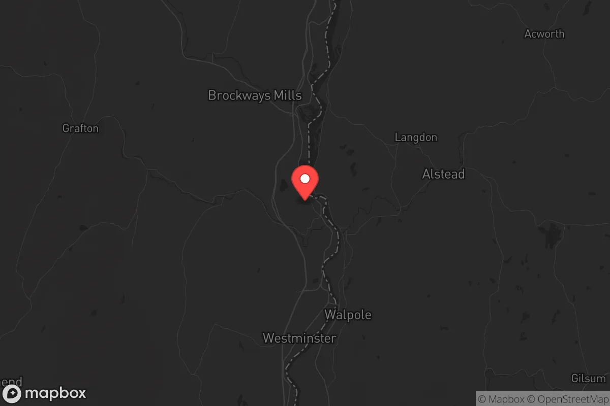
Bellows Falls, Vermont, sits in a strategic sweet spot that resilience-minded relocators should take seriously: it’s far enough from major metropolitan targets to avoid the worst of fallout and civil unrest, yet close enough to access critical supplies and medical care if needed. The village anchors the southern end of the Connecticut River Valley, with a population under 3,000, and benefits from the natural buffer of the Green Mountains to the west and the river itself as a defensible boundary. For a conservative-leaning individual or family looking to ride out national instability—whether from economic collapse, mass casualty events, or political violence—this location offers a rare combination of isolation and practical connectivity.
Geographic position and natural advantages for long-term survival
Bellows Falls sits at the intersection of the Connecticut River and the Rockingham town line, giving it a natural moat on its eastern flank. The river provides a reliable water source, while the surrounding hills—part of the Green Mountain range—offer elevation advantages for observation and defense. The village is roughly 30 miles north of Brattleboro and 60 miles south of Burlington, placing it outside the immediate blast or fallout zones of any major population center. The closest city of any size is Keene, New Hampshire, about 20 miles east, but even that is a small city of 23,000. For a prepper, this means you’re not in the shadow of a high-value target like Boston (120 miles south) or Montreal (150 miles north). The terrain itself is a defensive asset: narrow roads, dense forest, and steep grades make approach by any large force slow and detectable. The area’s agricultural history also means there are working farms and orchards within a 10-mile radius, which could be leveraged for food production in a grid-down scenario.
Risks, exposures, and proximity to fallout-relevant landmarks
No location is without risk, and Bellows Falls has a few that a strategic relocator must weigh. The Vermont Yankee nuclear power plant, located just 5 miles south in Vernon, was decommissioned in 2014, but the spent fuel remains stored on-site in dry casks. While the risk of a catastrophic release is low, a targeted attack or sabotage at this facility could render the immediate area uninhabitable for decades. The prevailing winds in the valley run north-south, meaning fallout from a Vermont Yankee incident would likely push toward Bellows Falls itself. Additionally, the village sits along the Connecticut River, which is a major transportation corridor; in a collapse scenario, this could become a route for refugees or looters moving north from more populated areas. Interstate 91 runs just west of the village, providing a direct highway link to Springfield, Massachusetts (70 miles south) and the chaos that would likely follow any major event. The village’s historic downtown, while charming, is dense and offers limited defensible space—row houses and narrow streets make it hard to secure a perimeter. For a family, the best approach is to secure a property on the outskirts, preferably on the western side of the river, where the terrain offers more natural cover.
Practical resilience for a relocator: food, water, energy, and defensibility
For a prepper moving to Bellows Falls, the practicalities of daily survival are manageable but require advance planning. The Connecticut River is a year-round water source, but it requires filtration and boiling due to agricultural runoff and upstream industrial history. The village’s municipal water system draws from wells, not the river, so in a grid-down scenario, residents with private wells on the outskirts will have a significant advantage. Food security is moderate: the Rockingham Farmers Market operates seasonally, and there are several small-scale farms within a 15-minute drive that sell meat, eggs, and produce directly. However, the growing season is short (roughly May to September), so long-term storage and hunting are essential. The surrounding forests hold deer, turkey, and small game, and the river offers fishing year-round. Energy resilience is a mixed bag: the area gets frequent winter storms that knock out power, so a generator with a 200-gallon propane tank is a wise investment. Solar is viable but limited by the valley’s cloud cover and tree canopy—ground-mounted panels on a south-facing slope would be ideal. Defensibility is the strongest card here. The village’s layout, with the river as a natural barrier and only a handful of bridges crossing it, means you can control access points. A property on the western hills, with a clear view of the valley and a single road approach, gives you a tactical advantage that few suburban or urban locations can match. The local population is small and largely self-reliant, which reduces the risk of resource conflicts compared to denser areas.
The overall strategic picture for Bellows Falls is one of cautious optimism for the prepared relocator. It’s not a bunker—it’s a real town with real vulnerabilities, including its proximity to a decommissioned nuclear site and a major highway. But for a conservative-leaning individual or family who values self-sufficiency, community discretion, and geographic isolation, it offers a foundation that can be hardened over time. The key is to buy land on the western side of the river, invest in off-grid water and power, and build relationships with the local farming community before any crisis hits. In a world where the next mass casualty event or civil unrest could come from any direction, Bellows Falls gives you a fighting chance to stay out of the blast radius and keep your family fed. The mountains and the river are your allies—use them wisely.
* Values derived from national, state, county, city and local statistics and may differ in a specific area. Last updated: 2026-04-30T02:21:45.000Z
Narrative content on this page is AI-generated and may contain mistakes. Verify any details that matter before acting on them.
ReloMaps may earn a commission from affiliate links at no extra cost to you.