Photo: Wikipedia
Strategic Assessment of Bertram, TX
Meaningful friction. Expect exposure to either population pressure, blast zones, or natural disaster risk. Consider buying a retreat property.
What does the Strategic Assessment tell us?
Our Strategic Assessment grades tactical survivability of an area. Major population centers, military targets, fallout zones, natural disasters, and border exposure all drive risk — lower exposure means a more defensible position in a crisis.
This is heavily inspired by Joel Skousen's Strategic Relocation book. Highly recommended you checkout the book ($)What does this tell us?
Our Strategic Assessment grades tactical survivability of an area. Major population centers, military targets, fallout zones, natural disasters, and border exposure all drive risk — lower exposure means a more defensible position in a crisis.
This is heavily inspired by Joel Skousen's Strategic Relocation book. Highly recommended you checkout the book ($)Strategic Pillars

Key Distances
Regional Safe Places
Below is our recommended "safe zones" in Texas and the surrounding area based on our strategic heuristics. For most people, it's unrealistic to live in a “safe zone” full-time due to work, family or other personal reasons. They tend to be more rural. However, many of these areas are perfect for second homes and retreat properties that double as a vacation home or even a short-term rental.


Important Note: For informational purposes only. This does not mean nothing bad ever happens in the green zones. Please use common sense. This is based on public data and modeled with AI. We tried to take a conservative approach but mistakes happen. We update this regularly as new information becomes available.
Solar Generator Recommendations
Backup power matters more here than in safer locations. We've picked three solar generators across budgets and capacity tiers — start with the budget unit if you only need a few essentials, or step up if you want to run a fridge and HVAC for days at a time.

Jackery Portable Power Station Explorer 300
Budget OptionPower on the Go: Weighing only 11 lbs, it's convenient to set up and store with book-sized foldable solar panels

BLUETTI Portable Power Station AC180
Designed for both indoor and outdoor scenarios, AC180 is highly capable as it has a robost capacity and continuous output power.

EF ECOFLOW DELTA Pro Ultra Power Station
Upgraded PickEcoFlow DELTA Pro Ultra is a whole-home energy system designed to grow with your family. Integrated with the Smart Home Panel 2, it scales to meet your evolving energy needs — keeping your home powered, intelligent, and secure through every stage of life.
We earn a commission, at no additional cost to you.
Strategic Assessment Analysis
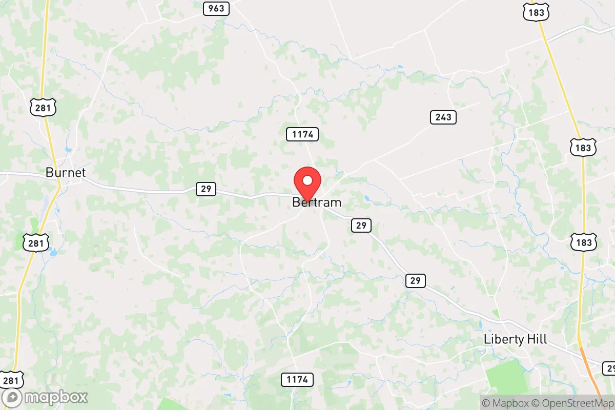
Bertram, Texas, offers a compelling strategic position for those prioritizing resilience and self-sufficiency, sitting roughly 45 miles north of Austin in a sparsely populated corridor of Burnet County. Its location places it outside the immediate blast and fallout zones of major metropolitan targets while still providing access to critical supply chains and medical infrastructure within a 90-minute drive. The town’s population hovers around 2,000, and the surrounding area is characterized by ranchland, limestone hills, and low-density development, which inherently reduces the risks associated with civil unrest or mass casualty events that tend to concentrate in urban centers. For a relocator with a prepper mindset, Bertram represents a balance between isolation and practical access, though it demands a clear-eyed assessment of its specific vulnerabilities.
Geographic position and natural advantages for long-term survival
Bertram sits on the edge of the Texas Hill Country, a region known for its varied topography, natural springs, and relatively low population density compared to the I-35 corridor. The town is roughly 15 miles west of I-35, a major north-south artery that could become a chokepoint during evacuation scenarios, but its position on State Highway 29 provides a secondary route toward Llano and the western Hill Country. The area’s elevation—around 1,200 feet—offers some protection against the flooding that plagues low-lying parts of Central Texas, and the rocky limestone soil drains quickly, reducing the risk of standing water and mosquito-borne disease after heavy rains. The surrounding Burnet County is part of the Llano Uplift, a geological formation that yields accessible granite and limestone for construction, as well as shallow groundwater in some areas. For a relocator, these natural features mean that well water is a viable option if you secure a property with a tested aquifer, and the rocky terrain makes the area less prone to the catastrophic wildfires that sweep through pine forests farther east. The climate is semi-arid, with hot summers and mild winters, which simplifies food storage and reduces heating fuel demands, but it also means that drought is a recurring threat—the region has experienced severe drought conditions in 7 of the last 15 years, according to the U.S. Drought Monitor.
Risks, exposures, and proximity to fallout-relevant landmarks
The primary strategic vulnerability of Bertram is its proximity to Austin, a major population center and state government hub that would be a high-priority target in any large-scale conflict or terrorist event. Austin is roughly 45 miles south, and prevailing winds in Central Texas generally blow from the south and southeast, meaning that fallout from a nuclear detonation in Austin would likely drift northward, directly over Bertram, within 2-4 hours depending on wind speed. The town is also within 60 miles of the South Texas Nuclear Generating Station near Bay City, though that facility is downwind of prevailing patterns for most of the year. More immediate concerns for a prepper include the proximity of I-35, which in a collapse scenario would become a funnel for refugees fleeing San Antonio, Austin, and Dallas-Fort Worth. Bertram is also near the Balcones Fault Zone, which produces minor seismic activity—typically below 3.0 magnitude—but the real risk is infrastructure failure: a major earthquake along the fault could disrupt the Highland Lakes dams upstream, potentially causing flash flooding along the Colorado River tributaries that drain through the area. The town itself has no direct rail lines or major industrial facilities, which reduces the risk of hazardous material spills, but the nearby city of Burnet (10 miles west) has a small airport and a rail spur that could become a target for sabotage.
Practical resilience for a relocator: food, water, energy, and defensibility
For a relocator serious about self-sufficiency, Bertram’s practical resilience hinges on three factors: water access, energy independence, and community dynamics. The area’s groundwater is generally reliable but varies significantly by location—well depths in Burnet County range from 100 to 400 feet, and yields can be as low as 5 gallons per minute in some areas, so pre-purchase testing is non-negotiable. Surface water is available from the North San Gabriel River, which runs just south of town, but access is limited by private land ownership and seasonal flow. Rainwater catchment is a strong option given the region’s average 32 inches of annual rainfall, though storage capacity must account for dry spells that can last 60-90 days. Energy-wise, the area has excellent solar potential—over 260 sunny days per year—and off-grid solar setups are common among rural residents, with local installers in Burnet and Liberty Hill familiar with battery backup systems. Natural gas is available in town limits, but rural properties rely on propane, which requires storage and resupply planning. Defensibility is moderate: the terrain is rolling with scattered oak and juniper, providing some cover, but the open ranchland leaves long sightlines for observation. The town’s small police department and volunteer fire service mean that response times in a crisis could exceed 30 minutes, so a relocator should plan for self-defense and fire suppression. The local population skews older and conservative, which can be an advantage for building a mutual-aid network, but newcomers should expect a cautious reception—community trust is earned over months, not weeks.
The overall strategic picture for Bertram is one of calculated trade-offs. It offers genuine advantages in terms of low population density, natural resource access, and distance from primary targets, but it is not a remote bunker location—it sits within a 90-minute drive of 2 million people, and that proximity carries real risk during a mass evacuation or fallout event. For a single individual or family willing to invest in well drilling, solar infrastructure, and a robust water storage system, Bertram provides a viable base for long-term resilience. The key is to treat it as a semi-rural outpost rather than a bug-out location: you can live there full-time, build local relationships, and maintain a low profile, but you must have a secondary plan for relocation farther west (toward Llano or Mason) if the Austin corridor collapses. The area’s conservative culture and self-reliant ethos align well with a prepper mindset, but the real test will be whether you can secure your own water and power before the next crisis hits—because in Bertram, the county won’t be coming to save you.
* Values derived from national, state, county, city and local statistics and may differ in a specific area. Last updated: 2026-05-09T22:55:17.000Z
Narrative content on this page is AI-generated and may contain mistakes. Verify any details that matter before acting on them.
ReloMaps may earn a commission from affiliate links at no extra cost to you.