Photo: Wikipedia
Strategic Assessment of Bridgehampton, NY
Meaningful friction. Expect exposure to either population pressure, blast zones, or natural disaster risk. Consider buying a retreat property.
What does the Strategic Assessment tell us?
Our Strategic Assessment grades tactical survivability of an area. Major population centers, military targets, fallout zones, natural disasters, and border exposure all drive risk — lower exposure means a more defensible position in a crisis.
This is heavily inspired by Joel Skousen's Strategic Relocation book. Highly recommended you checkout the book ($)What does this tell us?
Our Strategic Assessment grades tactical survivability of an area. Major population centers, military targets, fallout zones, natural disasters, and border exposure all drive risk — lower exposure means a more defensible position in a crisis.
This is heavily inspired by Joel Skousen's Strategic Relocation book. Highly recommended you checkout the book ($)Strategic Pillars

Key Distances
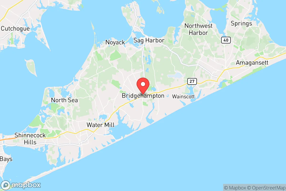
Regional Safe Places
Below is our recommended "safe zones" in New York and the surrounding area based on our strategic heuristics. For most people, it's unrealistic to live in a “safe zone” full-time due to work, family or other personal reasons. They tend to be more rural. However, many of these areas are perfect for second homes and retreat properties that double as a vacation home or even a short-term rental.


Important Note: For informational purposes only. This does not mean nothing bad ever happens in the green zones. Please use common sense. This is based on public data and modeled with AI. We tried to take a conservative approach but mistakes happen. We update this regularly as new information becomes available.
Solar Generator Recommendations
Backup power matters more here than in safer locations. We've picked three solar generators across budgets and capacity tiers — start with the budget unit if you only need a few essentials, or step up if you want to run a fridge and HVAC for days at a time.

Jackery Portable Power Station Explorer 300
Budget OptionPower on the Go: Weighing only 11 lbs, it's convenient to set up and store with book-sized foldable solar panels

BLUETTI Portable Power Station AC180
Designed for both indoor and outdoor scenarios, AC180 is highly capable as it has a robost capacity and continuous output power.

EF ECOFLOW DELTA Pro Ultra Power Station
Upgraded PickEcoFlow DELTA Pro Ultra is a whole-home energy system designed to grow with your family. Integrated with the Smart Home Panel 2, it scales to meet your evolving energy needs — keeping your home powered, intelligent, and secure through every stage of life.
We earn a commission, at no additional cost to you.
Strategic Assessment Analysis
Bridgehampton, New York, presents a paradox for the strategic relocator: it offers genuine geographic resilience in the form of a semi-isolated peninsula with abundant natural resources, yet it sits within spitting distance of one of the highest-value target zones on the Eastern Seaboard. For a conservative-minded individual or family prioritizing self-sufficiency and security, this location demands a clear-eyed assessment of trade-offs. The area’s natural advantages—defensible terrain, a moderate climate, and access to the Atlantic—are real, but they are offset by proximity to New York City’s fallout shadow and the logistical choke points of Long Island’s narrow geography. The key question is whether the benefits of a low-density, resource-rich environment outweigh the risks of being trapped on an island during a major crisis.
Geographic position and natural advantages for long-term survival
Bridgehampton’s location at the eastern end of Long Island’s South Fork provides several structural advantages for a prepper or survivalist. The area is bounded by the Atlantic Ocean to the south and Gardiners Bay to the north, creating a natural buffer against overland threats. The local topography is flat to gently rolling, with sandy soils that drain well—useful for both agriculture and avoiding floodplain issues in most areas. The maritime climate moderates temperature extremes, meaning heating fuel demand is lower than in upstate New York, and the growing season is longer, typically from April through October. Freshwater access is a genuine asset: the area sits atop a substantial aquifer, and there are numerous ponds, including Mecox Bay and Georgica Pond, though these are brackish and require treatment. For a relocator, the ability to dig a well (typical depths of 50–150 feet yield potable water) and the presence of local farms—such as the historic Bridgehampton Farm—offer a foundation for food production that many suburban areas lack. The surrounding landscape includes extensive preserved farmland and nature preserves, which could serve as both game habitat and foraging grounds in a prolonged disruption. The population density is low by Long Island standards—roughly 200 people per square mile in the hamlet proper—which reduces competition for resources compared to western Suffolk or Nassau counties.
Risks, exposures, and proximity to fallout-relevant landmarks
The most significant vulnerability of Bridgehampton is its position on a narrow, 120-mile-long peninsula that is effectively a dead end. In any scenario involving a major evacuation from New York City—whether due to a nuclear event, a biological release, or civil unrest—the roads leading east (primarily the Long Island Expressway, Sunrise Highway, and Montauk Highway) would become impassable within hours. Bridgehampton is roughly 90 miles from Manhattan, placing it within the moderate fallout zone for a surface burst at the city’s core. Prevailing winds from the west would carry radioactive debris directly over the area, with arrival times of 2–4 hours depending on yield. The nearby Brookhaven National Laboratory, about 30 miles west, is a secondary concern for radiological release. Additionally, the area is within 50 miles of the Indian Point nuclear facility (though it is decommissioned, spent fuel remains on site), and the Montauk Air Force Station—a former radar site—is a potential target for a kinetic strike. The Shinnecock Nation’s reservation and the surrounding coastal areas also host sensitive infrastructure, including the Shinnecock Canal, which is a critical chokepoint for maritime traffic. For a relocator, the risk of being trapped on the South Fork with no viable escape route to the mainland is the single greatest strategic liability. The only bridges off Long Island are at the western end, meaning any crisis that blocks those crossings effectively turns the entire island into a cage.
Practical resilience for a relocator: food, water, energy, and defensibility
For those who choose to locate here, Bridgehampton offers a mix of assets and liabilities for daily self-sufficiency. Water is the strongest asset: the Upper Glacial aquifer provides reliable groundwater, and many homes already have private wells. In a grid-down scenario, a hand pump or solar-powered pump can maintain access, though saltwater intrusion is a risk near the coast. Food production is viable but requires work: the area’s agricultural history means good soil and a network of local farms, but the growing season is limited, and deer pressure is high (hunting is permitted in season, with a valid license). The Atlantic offers a protein source—striped bass, fluke, and shellfish are abundant—but fishing requires skill and gear, and coastal access points may become contested. Energy is a mixed picture: the region has good solar insolation, and many homes have backup generators, but natural gas pipelines are limited, and propane deliveries could cease during a prolonged disruption. Wood heating is possible but not widespread; most homes rely on oil or propane. Defensibility is moderate: the area’s low density and limited road network (only a few main arteries) make it easier to monitor approach routes, but the flat terrain offers little cover, and the proximity to the ocean means a potential threat from maritime approaches. The local population skews wealthy and seasonal, meaning many homes are unoccupied for large parts of the year—a double-edged sword that reduces competition but also invites looting. The nearest hospital is Stony Brook Southampton Hospital, about 10 miles west, which is a Level 3 trauma center—adequate for routine emergencies but likely overwhelmed in a mass casualty event.
The strategic picture for Bridgehampton is one of high reward tempered by high risk. For a relocator who can secure a well-equipped property, establish a local network, and stockpile supplies for a 6–12 month period, the area offers a defensible, resource-rich base that could sustain a family through a moderate disruption. The climate is forgiving, the water is clean, and the isolation from urban centers is real—until it isn’t. The fatal flaw is the geographic trap: any event that closes the western exits turns the South Fork into a dead end, and the fallout risk from a New York City strike is non-trivial. For a conservative prepper who values self-reliance and is willing to accept the island’s constraints, Bridgehampton can work as a secondary retreat or a primary residence with a strong plan for early evacuation. But for those seeking a location with multiple escape routes and minimal target value, the Hudson Valley or the Adirondacks offer a more secure long-term bet. The bottom line: Bridgehampton is a beautiful, resource-rich location that demands a serious risk assessment and a robust contingency plan for the day the bridges close.
* Values derived from national, state, county, city and local statistics and may differ in a specific area. Last updated: 2026-04-24T01:49:11.000Z
Narrative content on this page is AI-generated and may contain mistakes. Verify any details that matter before acting on them.
ReloMaps may earn a commission from affiliate links at no extra cost to you.