
Photo: Wikipedia
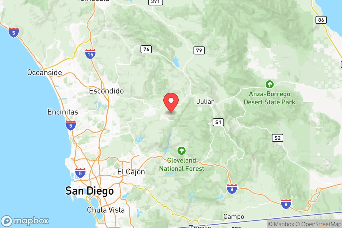
Strategic Assessment of San Diego County
Multiple tactical vulnerabilities. Population density, target proximity, or disaster risk are likely compounding. A retreat property and exit planning is required.
What does the Strategic Assessment tell us?
Our Strategic Assessment grades tactical survivability of an area. Major population centers, military targets, fallout zones, natural disasters, and border exposure all drive risk — lower exposure means a more defensible position in a crisis.
This is heavily inspired by Joel Skousen's Strategic Relocation book. Highly recommended you checkout the book ($)What does this tell us?
Our Strategic Assessment grades tactical survivability of an area. Major population centers, military targets, fallout zones, natural disasters, and border exposure all drive risk — lower exposure means a more defensible position in a crisis.
This is heavily inspired by Joel Skousen's Strategic Relocation book. Highly recommended you checkout the book ($)Strategic Pillars

Key Distances
Strategic Assessment Analysis
San Diego County offers a complex strategic picture for the conservative prepper: its coastal location provides natural buffer zones and a temperate climate that reduces many survival stressors, but its proximity to a major international border, a massive military-industrial complex, and a densely populated urban core introduces significant vulnerabilities. The county’s resilience is tied to its geography—the Pacific Ocean to the west, the Cleveland National Forest and Laguna Mountains to the east, and Camp Pendleton to the north create a semi-isolated basin. However, that same geography funnels threats through a narrow corridor, making it a high-risk, high-reward proposition for those prioritizing long-term self-sufficiency over immediate security.
Geographic position and natural advantages for long-term survival
San Diego County’s natural defenses are its strongest asset. The Pacific Ocean provides a secure western flank, while the Laguna Mountains and Cleveland National Forest create a rugged eastern barrier that slows overland movement and offers high-altitude retreat options. The county’s Mediterranean climate—average highs in the 70s year-round—means no brutal winters to kill crops or freeze water lines, a critical advantage for off-grid living. The San Luis Rey River and Otay River watersheds provide reliable freshwater sources, though they are heavily tapped by municipal systems. For a relocator, the backcountry areas around Julian and Pine Valley offer defensible terrain with limited road access, ideal for a bug-out location. The county’s position as a naval and Marine Corps hub—home to Naval Base San Diego and Marine Corps Base Camp Pendleton—means heavy military presence, which can deter large-scale civil unrest but also makes the area a target for state-actor attacks. The border with Tijuana adds a layer of complexity: while it provides a potential escape route south, it also funnels illegal cross-border traffic and cartel activity into the southern parts of the county.
Risks, exposures, and proximity to fallout-relevant landmarks
The same assets that make San Diego County attractive also make it a high-priority target. Naval Base San Diego and Camp Pendleton are primary nuclear and conventional strike targets, with the San Diego International Airport and Port of San Diego serving as secondary logistical hubs. A single warhead on the naval base would produce a fallout plume that could blanket much of the coastal strip, including La Jolla, Pacific Beach, and Chula Vista, depending on wind direction. The South Bay Power Plant (decommissioned but still containing hazardous materials) and the San Onofre Nuclear Generating Station (just north in Orange County) add radiological risks. For the prepper, the I-5 and I-15 corridors are choke points that will gridlock during any evacuation, making eastward escape through Pine Valley or Boulevard a race against time. The county’s 3.3 million residents create a density problem: even a localized disaster—like a wildfire or earthquake—could trigger mass panic and resource shortages. The San Andreas Fault runs just east of the county, and a major quake could collapse the San Diego-Coronado Bridge and damage the Otay Mesa Dam, cutting off water and escape routes. Cartel activity along the border near Otay Mesa and Tecate adds a persistent low-level security threat, with potential for cross-border violence spilling into residential areas.
Practical resilience for a relocator: food, water, energy, and defensibility
For a relocator serious about self-sufficiency, San Diego County offers a mixed bag. Water is the biggest concern: the county imports 70-80% of its water from the Colorado River and the State Water Project, meaning any disruption to those systems—whether from earthquake, cyberattack, or drought—would leave most residents high and dry. The San Diego County Water Authority has some local storage in reservoirs like Lake Hodges and San Vicente Reservoir, but these are finite and heavily monitored. A prepper would need to secure a property with a private well in the backcountry, ideally in the Palomar Mountain or Cuyamaca areas, where groundwater is more reliable. Food production is viable year-round due to the climate, but the county’s agricultural land is concentrated in the North County (avocados, citrus) and the Imperial Valley (just east), which is a separate region. For energy, solar is a no-brainer—the county averages 266 sunny days per year—but grid dependency is high, and the San Diego Gas & Electric infrastructure is vulnerable to wildfire and earthquake damage. Defensibility varies wildly: coastal neighborhoods like Encinitas and Carlsbad are exposed and crowded, while the backcountry near Warner Springs offers limited road access and natural cover. The Camp Pendleton buffer zone to the north provides a security corridor, but it also means any major conflict involving the base will draw attention to the area. For a single individual or family, the best bet is a rural property in the East County (e.g., Jacumba Hot Springs Mountain area) with a well, solar panels, and a defensible perimeter, but expect to pay a premium—land prices in those areas have been climbing as urban refugees seek the same advantages.
The overall strategic picture for San Diego County is one of high potential paired with high exposure. The climate and geography are nearly ideal for long-term survival, but the county’s role as a military and economic hub makes it a likely target in any major conflict. For the conservative prepper, the calculus comes down to location: the coastal strip is a death trap in a crisis, while the backcountry offers a viable retreat if you can secure water and avoid the evacuation chokepoints. The border proximity adds a wildcard—cartel activity and illegal traffic are manageable in peacetime but could become a serious security issue during civil unrest. If you’re willing to invest in a well-fortified property in the Laguna Mountains or Palomar area, and you have the resources to stockpile supplies and maintain off-grid systems, San Diego County can work. But for those seeking a low-risk, low-profile location away from major targets and population centers, the county’s density and strategic importance make it a gamble that many preppers will find too risky. The smart move is to treat it as a secondary retreat, not a primary survival hub, unless you have deep pockets and a high tolerance for uncertainty.
* Values derived from national, state, county, city and local statistics and may differ in a specific area. Last updated: 2026-05-17T12:01:21.000Z
Narrative content on this page is AI-generated and may contain mistakes. Verify any details that matter before acting on them.
ReloMaps may earn a commission from affiliate links at no extra cost to you.