Photo: Wikipedia
Strategic Assessment of Stanislaus County
Meaningful friction. Expect exposure to either population pressure, blast zones, or natural disaster risk. Consider buying a retreat property.
What does the Strategic Assessment tell us?
Our Strategic Assessment grades tactical survivability of an area. Major population centers, military targets, fallout zones, natural disasters, and border exposure all drive risk — lower exposure means a more defensible position in a crisis.
This is heavily inspired by Joel Skousen's Strategic Relocation book. Highly recommended you checkout the book ($)What does this tell us?
Our Strategic Assessment grades tactical survivability of an area. Major population centers, military targets, fallout zones, natural disasters, and border exposure all drive risk — lower exposure means a more defensible position in a crisis.
This is heavily inspired by Joel Skousen's Strategic Relocation book. Highly recommended you checkout the book ($)Strategic Pillars

Key Distances
Strategic Assessment Analysis
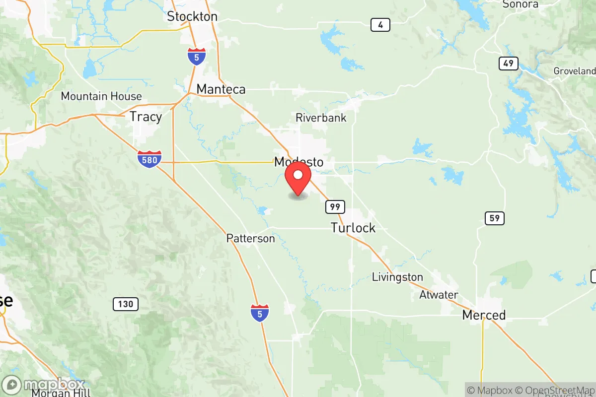
Stanislaus County offers a surprisingly resilient strategic position for those looking to balance California’s economic access with a buffer from the state’s most volatile urban and industrial centers. Sitting in the heart of the Central Valley, roughly 90 miles east of San Francisco and 30 miles south of Stockton, the county avoids the direct fallout zones of the Bay Area’s refinery corridor and the Port of Oakland while still being close enough to leverage supply routes. For a relocator with a prepper mindset, the key advantage here is that you’re not in the blast radius of a major port or military installation like Travis Air Force Base, yet you’re within a day’s drive of the Sierra Nevada redoubt if things go sideways. The county’s agricultural backbone—over 1,500 square miles of farmland—means local food production is a tangible asset, not just a talking point.
Geographic position and natural advantages for strategic relocation
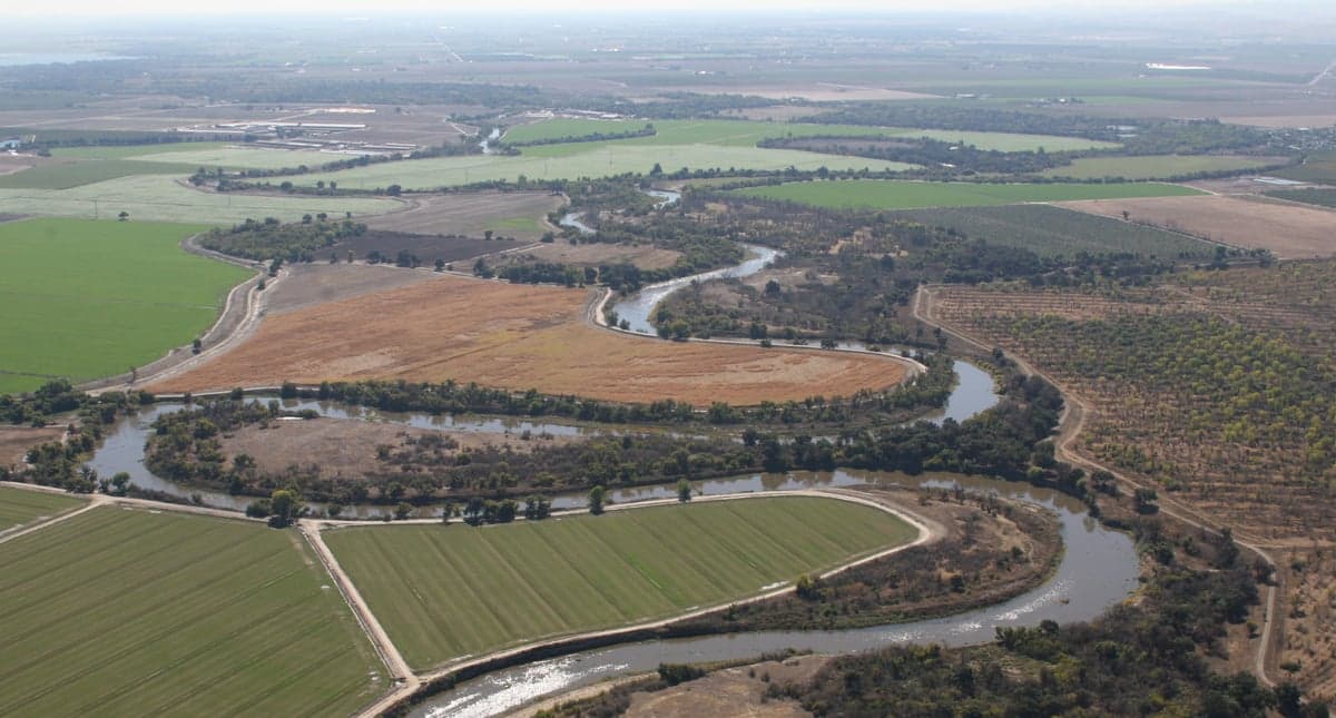
Stanislaus County sits at a geographic sweet spot that many preppers overlook. The county is bisected by the Tuolumne River and the San Joaquin River, providing a reliable freshwater source that doesn’t depend on the fragile Delta pumps further north. The city of Modesto, the county seat, is the urban anchor, but the real strategic value lies in the smaller towns like Oakdale, Riverbank, and Patterson. Oakdale, for instance, sits at the foothills of the Sierra Nevada, offering a quick escape route east on Highway 108 toward the Stanislaus National Forest—a classic bug-out corridor. Patterson, on the western edge, is closer to Interstate 5, giving you a north-south lifeline that avoids the congestion of the Bay Area. The county’s elevation ranges from about 50 feet in the valley floor to over 3,000 feet in the eastern hills, meaning you can choose your defensibility level. The natural advantages here are twofold: abundant groundwater (the county sits atop a significant aquifer) and a Mediterranean climate that allows for year-round food production. For a conservative-leaning relocator, this means you’re not dependent on fragile supply chains for basic necessities—you can grow your own, and the local ag economy means you can barter or buy direct from farmers.
Risks, exposures, and proximity to fallout-relevant landmarks
No strategic assessment is honest without addressing the risks, and Stanislaus County has a few that demand attention. The most immediate concern is proximity to the San Onofre Nuclear Generating Station—though that’s 300 miles south, the real threat is closer: the Port of Stockton and the Sacramento River Delta are both within 30 miles. Stockton is a major inland port handling fertilizer, cement, and petroleum products, making it a potential target for sabotage or accident. The Delta itself is a critical water infrastructure hub; if it’s compromised, the Central Valley’s irrigation system takes a hit. Additionally, the county is crisscrossed by major rail lines (Union Pacific and BNSF) that carry hazardous materials through Modesto and Ceres. A derailment or targeted attack on these lines could disrupt supply routes and create localized contamination. On the natural disaster front, the county sits in a seismic zone—the nearby Greenville Fault and San Andreas Fault (about 60 miles west) could produce a major quake that liquefies the valley soil, damaging roads and pipelines. Flooding is also a real risk along the Tuolumne and San Joaquin rivers, especially in low-lying areas like Grayson and Westley. For the prepper, the takeaway is that you need to choose your specific location carefully: avoid floodplains, stay away from rail corridors, and have a plan to move east toward the foothills if the Delta goes down.
Practical resilience for a relocator: food, water, energy, and defensibility
When you break down the practical resilience factors, Stanislaus County scores well on food and water but has gaps in energy and defensibility that require planning. Food is the strongest asset: the county is a top producer of almonds, milk, and poultry, with over 2,000 farms operating within its borders. You can buy directly from producers at farmers’ markets in Modesto, Turlock, and Oakdale, or join a CSA (community-supported agriculture) program. For long-term storage, local feed stores sell bulk grains and seeds. Water is also a plus—the county’s groundwater basin is managed by the Stanislaus County Water District, and many rural properties have wells. However, during drought years (which are becoming more frequent), the state can restrict pumping, so having a backup storage tank is wise. Energy is a mixed bag: the grid is served by PG&E, which has a notorious track record for public safety power shutoffs (PSPS) during wildfire season. Solar is a viable option, but the valley’s summer heat (often over 100°F) means you’ll need battery storage to keep cooling running. Natural gas is widely available in urban areas, but rural properties may rely on propane. Defensibility is where you need to be strategic. The valley floor is flat and open, making it hard to secure a large property without significant investment in fencing and surveillance. The eastern foothills near Oakdale and Knights Ferry offer better terrain for a retreat-style setup—think wooded hills, narrow roads, and natural chokepoints. The county’s population density is moderate (about 550,000 total), so you’re not dealing with urban chaos, but you’re also not isolated enough to ignore the risk of refugees from the Bay Area in a crisis. A solid OPSEC (operational security) plan—keeping a low profile, storing supplies discreetly, and building a trusted network—is essential.
The overall strategic picture for Stanislaus County is one of calculated trade-offs. You get the agricultural self-sufficiency and water security that many California counties lack, but you’re still within the shadow of the state’s fragile infrastructure—the Delta, the rail lines, and the PG&E grid. For a single individual or a family with a conservative, preparedness-oriented mindset, the best play is to target the eastern edge of the county, near Oakdale or the Stanislaus River corridor, where you can leverage the Sierra Nevada as a secondary position. Avoid the urban core of Modesto and the flood-prone areas along the San Joaquin. If you’re willing to invest in off-grid energy and water storage, and you have a plan for dealing with the inevitable PSPS events and potential supply chain disruptions, Stanislaus County can serve as a viable base of operations. It’s not a bug-out location in itself—it’s a staging ground that gives you time and resources to make a move if the situation deteriorates. That’s a realistic assessment, not a sales pitch, and that’s exactly what a strategic relocator needs to hear.
* Values derived from national, state, county, city and local statistics and may differ in a specific area. Last updated: 2026-05-30T05:04:31.000Z
Narrative content on this page is AI-generated and may contain mistakes. Verify any details that matter before acting on them.
ReloMaps may earn a commission from affiliate links at no extra cost to you.