
Photo: Wikipedia
Strategic Assessment of Carrington, ND
Strong survivability profile. Good buffer from population centers, with manageable environmental and tactical risks.
What does the Strategic Assessment tell us?
Our Strategic Assessment grades tactical survivability of an area. Major population centers, military targets, fallout zones, natural disasters, and border exposure all drive risk — lower exposure means a more defensible position in a crisis.
This is heavily inspired by Joel Skousen's Strategic Relocation book. Highly recommended you checkout the book ($)What does this tell us?
Our Strategic Assessment grades tactical survivability of an area. Major population centers, military targets, fallout zones, natural disasters, and border exposure all drive risk — lower exposure means a more defensible position in a crisis.
This is heavily inspired by Joel Skousen's Strategic Relocation book. Highly recommended you checkout the book ($)Strategic Pillars

Key Distances
Regional Safe Places
Below is our recommended "safe zones" in North Dakota and the surrounding area based on our strategic heuristics. For most people, it's unrealistic to live in a “safe zone” full-time due to work, family or other personal reasons. They tend to be more rural. However, many of these areas are perfect for second homes and retreat properties that double as a vacation home or even a short-term rental.
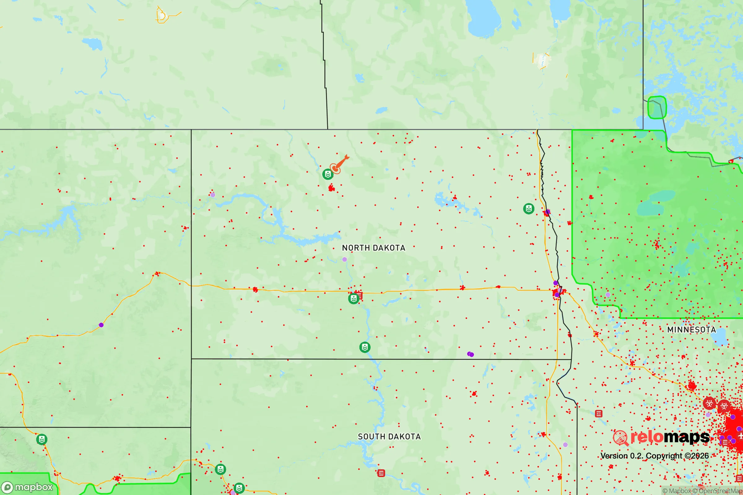
Important Note: For informational purposes only. This does not mean nothing bad ever happens in the green zones. Please use common sense. This is based on public data and modeled with AI. We tried to take a conservative approach but mistakes happen. We update this regularly as new information becomes available.
Solar Generator Recommendations
Backup power matters more here than in safer locations. We've picked three solar generators across budgets and capacity tiers — start with the budget unit if you only need a few essentials, or step up if you want to run a fridge and HVAC for days at a time.

Jackery Portable Power Station Explorer 300
Budget OptionPower on the Go: Weighing only 11 lbs, it's convenient to set up and store with book-sized foldable solar panels

BLUETTI Portable Power Station AC180
Designed for both indoor and outdoor scenarios, AC180 is highly capable as it has a robost capacity and continuous output power.

EF ECOFLOW DELTA Pro Ultra Power Station
Upgraded PickEcoFlow DELTA Pro Ultra is a whole-home energy system designed to grow with your family. Integrated with the Smart Home Panel 2, it scales to meet your evolving energy needs — keeping your home powered, intelligent, and secure through every stage of life.
We earn a commission, at no additional cost to you.
Strategic Assessment Analysis
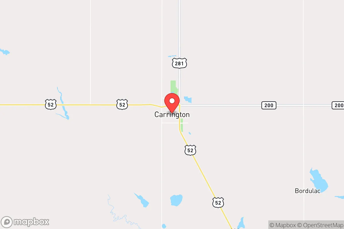
Carrington, North Dakota, offers a strategic relocation option for those prioritizing long-term resilience, civic stability, and geographic isolation from major population centers. Situated in Foster County, this community of roughly 4,000 people sits at the intersection of U.S. Highway 281 and North Dakota Highway 200, placing it roughly 90 miles from the Fargo metro area and 100 miles from Bismarck. This distance from large cities is a deliberate advantage—it provides a buffer from the cascading effects of urban unrest, supply chain disruptions, or mass casualty events that tend to concentrate in dense populations. The area's agricultural economy, low crime rates, and strong sense of local governance make it a viable base for those seeking to weather broader societal instability without being completely off the grid.
Geographic position and natural advantages for long-term stability
Carrington's location in the central part of the state places it within the Drift Prairie region, characterized by flat to gently rolling terrain, fertile soils, and a climate that supports both crop and livestock operations. The area sits atop the Dakota Aquifer, a significant groundwater resource that provides reliable access to potable water even during drought conditions—a critical factor for any prepper or survivalist scenario. The region's low population density (Foster County has roughly 3.3 people per square mile) means that in a crisis, competition for resources like fuel, food, and medical supplies would be far less intense than in suburban or urban environments. Winters are harsh, with average January lows around -2°F and annual snowfall near 40 inches, but this climate acts as a natural deterrent to transient populations and opportunistic threats. The growing season is short (roughly 120 days), but the area's agricultural output—primarily wheat, soybeans, corn, and sunflowers—means that local food production is a built-in advantage, not a theoretical one.
Risks, exposures, and proximity to fallout-relevant landmarks
No location is without risk, and Carrington's strategic profile requires a clear-eyed assessment of its vulnerabilities. The primary concern is its proximity to Minot Air Force Base, roughly 110 miles to the northwest, which houses nuclear-capable B-52 bombers and is a high-priority target in any major conflict scenario. While 110 miles provides a meaningful buffer from direct blast effects, fallout patterns depend on prevailing winds—typically west-to-east in this region—meaning Carrington could be downwind of a strike on Minot or the missile fields in the north-central part of the state. The Garrison Dam on the Missouri River, about 80 miles west, is another critical infrastructure point; a catastrophic failure or targeted attack could disrupt water supplies and power generation for the region. On the positive side, Carrington is far from major petrochemical facilities, nuclear power plants, or large military command centers that would be primary targets. The nearest major rail hub is in Jamestown (40 miles south), which could become a chokepoint for supply chains but also a potential vector for unrest or disease spread. The town's small size and lack of high-value industrial targets make it a low-priority location for any adversary, which is a significant advantage in a prolonged crisis scenario.
Practical resilience for a relocator: food, water, energy, and defensibility
For a relocator with a prepper mindset, Carrington offers several concrete advantages that can be leveraged immediately. Water security is strong: the Dakota Aquifer provides deep groundwater access, and the nearby James River (a tributary of the Missouri) offers surface water for non-potable uses. Most residential properties in the area have private wells or are connected to municipal systems that draw from reliable sources. Food production is the standout feature—Foster County is one of the most productive agricultural counties in the state, with local grain elevators, seed suppliers, and farm equipment dealers that make small-scale farming or homesteading feasible. The Carrington Research Extension Center, operated by North Dakota State University, provides local expertise on crop and livestock management, a resource not available in most rural towns. Energy resilience is moderate: the area is served by Basin Electric Power Cooperative, which operates coal and natural gas plants in the region, but grid failures during winter storms are a known risk. Solar potential is limited by latitude and cloud cover, but wind energy is abundant—many rural properties already have small wind turbines or could install them with relative ease. Defensibility is a mixed picture. The flat terrain offers long sightlines but limited natural cover, making a perimeter defense challenging. However, the town's layout—a compact grid with a few main arteries—means that chokepoints can be established on the highways entering town. The local law enforcement presence is small (Foster County Sheriff's Office has roughly 5-6 deputies), so community self-reliance is a practical necessity, not a theoretical ideal. The nearest hospital is CHI St. Alexius Health Carrington, a 25-bed critical access facility that can handle basic emergencies but would be overwhelmed by mass casualty events—a reality that underscores the need for medical self-sufficiency.
The overall strategic picture for Carrington is one of calculated trade-offs. It offers genuine resilience in food and water security, low population density, and distance from primary target zones, but it demands a willingness to endure harsh winters, limited medical infrastructure, and a reliance on personal preparedness rather than institutional support. For a conservative-leaning individual or family looking to establish a base that can function independently during periods of civic unrest or national disruption, Carrington provides a solid foundation—provided you arrive with the skills, supplies, and mindset to handle the isolation and the cold. It is not a bug-out location for a weekend; it is a long-term settlement for those who understand that resilience is built, not bought.
* Values derived from national, state, county, city and local statistics and may differ in a specific area. Last updated: 2026-04-19T05:30:51.000Z
Narrative content on this page is AI-generated and may contain mistakes. Verify any details that matter before acting on them.
ReloMaps may earn a commission from affiliate links at no extra cost to you.