Photo: Wikipedia
Strategic Assessment of Central Falls, RI
Multiple tactical vulnerabilities. Population density, target proximity, or disaster risk are likely compounding. A retreat property and exit planning is required.
What does the Strategic Assessment tell us?
Our Strategic Assessment grades tactical survivability of an area. Major population centers, military targets, fallout zones, natural disasters, and border exposure all drive risk — lower exposure means a more defensible position in a crisis.
This is heavily inspired by Joel Skousen's Strategic Relocation book. Highly recommended you checkout the book ($)What does this tell us?
Our Strategic Assessment grades tactical survivability of an area. Major population centers, military targets, fallout zones, natural disasters, and border exposure all drive risk — lower exposure means a more defensible position in a crisis.
This is heavily inspired by Joel Skousen's Strategic Relocation book. Highly recommended you checkout the book ($)Strategic Pillars

Key Distances
Regional Safe Places
Below is our recommended "safe zones" in Rhode Island and the surrounding area based on our strategic heuristics. For most people, it's unrealistic to live in a “safe zone” full-time due to work, family or other personal reasons. They tend to be more rural. However, many of these areas are perfect for second homes and retreat properties that double as a vacation home or even a short-term rental.


Important Note: For informational purposes only. This does not mean nothing bad ever happens in the green zones. Please use common sense. This is based on public data and modeled with AI. We tried to take a conservative approach but mistakes happen. We update this regularly as new information becomes available.
Solar Generator Recommendations
Backup power matters more here than in safer locations. We've picked three solar generators across budgets and capacity tiers — start with the budget unit if you only need a few essentials, or step up if you want to run a fridge and HVAC for days at a time.

Jackery Portable Power Station Explorer 300
Budget OptionPower on the Go: Weighing only 11 lbs, it's convenient to set up and store with book-sized foldable solar panels

BLUETTI Portable Power Station AC180
Designed for both indoor and outdoor scenarios, AC180 is highly capable as it has a robost capacity and continuous output power.

EF ECOFLOW DELTA Pro Ultra Power Station
Upgraded PickEcoFlow DELTA Pro Ultra is a whole-home energy system designed to grow with your family. Integrated with the Smart Home Panel 2, it scales to meet your evolving energy needs — keeping your home powered, intelligent, and secure through every stage of life.
We earn a commission, at no additional cost to you.
Strategic Assessment Analysis
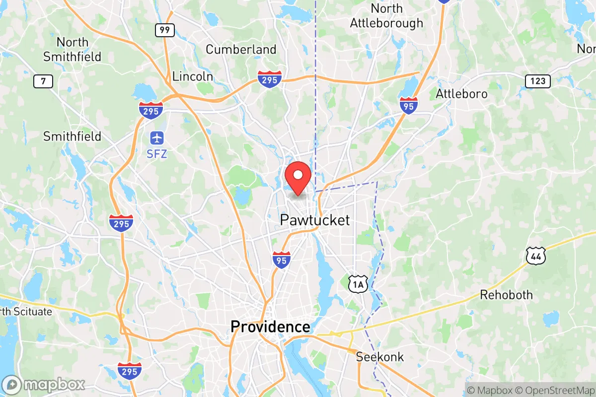
Central Falls, Rhode Island, presents a complex strategic picture for the conservative prepper or survivalist. While its location in the densely populated Northeast corridor is a significant liability for those seeking true retreat, the city’s own history of economic hardship and tight-knit community structure offers unexpected lessons in resilience. For a relocator, this is not a bug-out destination but a case study in the vulnerabilities and potential strengths of a post-industrial urban environment under pressure.
Geographic position and natural advantages for a survivalist
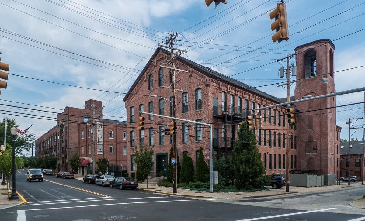
Central Falls sits in a tight, 1.2-square-mile footprint along the Blackstone River, just north of Providence. Its geographic position is a double-edged sword. On one hand, the Blackstone River provides a reliable water source, and the surrounding Blackstone Valley offers some of the most fertile soil in southern New England. The city is within a 30-minute drive of rural Massachusetts and the forests of northern Rhode Island, which could serve as secondary fallback zones. On the other hand, the city is landlocked and hemmed in by Interstate 95, Route 146, and the Providence and Worcester Railroad line. These transportation arteries are choke points in a crisis. A single bridge or highway closure could isolate the city from supply routes, but they also mean that a prepared individual could monitor movement along these corridors from elevated positions in the city’s older mill buildings. The natural advantage here is not wilderness but density of structure—the city’s brick mills and narrow streets offer a form of urban defensibility that a suburban cul-de-sac cannot match. The Blackstone River Bikeway, a converted rail trail, provides a non-motorized evacuation route north toward Woonsocket and the Massachusetts border, a detail often overlooked in standard relocation guides.
Risks, exposures, and proximity to fallout-relevant landmarks
The primary strategic liability of Central Falls is its proximity to high-value, high-risk targets. The city lies roughly 45 miles southwest of Boston and 15 miles north of Providence, both major population centers that would be primary targets in a large-scale conflict or terrorist event. The nearby Quonset Point Naval Air Station (30 miles south) and the submarine base in Groton, Connecticut (50 miles southwest) are obvious military targets. More concerning for the prepper is the city’s location within the Northeast Corridor’s industrial and chemical belt. The Blackstone River itself carries legacy industrial pollution, and the area is dotted with former textile mills that may contain hazardous materials. In a societal collapse scenario, the dense population of the Providence metro area—over 1.6 million people—would create a massive refugee flow north along I-95, directly through Central Falls. The city’s own population density (over 20,000 people per square mile) means that any localized disaster—a chemical spill, a bridge collapse, or a disease outbreak—would spread rapidly. The risk of civil unrest is elevated here due to the city’s high poverty rate (over 20%) and its status as a gateway for immigrant populations, which could create friction points during resource shortages. For the survivalist, this is not a place to ride out a long-term crisis; it is a place to pass through or to use as a temporary staging area before moving to more defensible ground.
Practical resilience for a relocator: food, water, energy, and defensibility
For the relocator considering Central Falls as a base, the practical resilience picture is mixed. Water is the strongest asset. The Blackstone River is a perennial water source, though it requires heavy filtration and boiling due to industrial runoff. The city’s municipal water comes from the Scituate Reservoir, which is well-protected but vulnerable to contamination or sabotage. A prepper should plan for at least two independent water sources: the river and a rainwater catchment system. Food production is limited by the city’s urban footprint. There are community gardens, but they are small and would be quickly overwhelmed. The best option is to establish relationships with farmers in nearby rural towns like Foster or Glocester, which are 20-30 minutes away. Energy is a vulnerability. The grid is old and prone to outages, especially during winter storms. Natural gas lines run through the city, but a prepper should assume they will be disrupted. Solar panels are viable on flat-roofed mill buildings, but the city’s narrow streets and tall buildings create shading issues. A generator with a secure fuel cache is essential. Defensibility is the city’s hidden card. The dense, walkable layout means that a small group could control a block or a single mill building. The old brick structures offer good ballistic protection, and the city’s many alleys and back lots provide covered movement routes. However, the lack of natural barriers—no hills, no forests, no rivers wide enough to stop a determined group—means that defense requires constant vigilance. The community itself is a wildcard. Central Falls has a strong sense of local identity, forged through decades of economic struggle. In a crisis, this could translate into mutual aid networks or, conversely, into turf battles. The relocator should invest in building trust with neighbors before any event, not after.
The overall strategic picture for Central Falls is one of calculated risk. It is not a retreat location for the lone wolf or the family seeking self-sufficiency. It is a location for the prepper who understands that the best defense is often a good offense—someone who can leverage the city’s density for short-term security while maintaining a clear exit plan to the north or west. The city’s proximity to major targets and its own internal pressures make it a high-risk, medium-reward proposition. For the conservative relocator who values community resilience and is willing to trade isolation for tactical advantages, Central Falls offers a unique, if demanding, strategic option. But for those whose primary goal is to avoid the chaos of the collapsing cities, the advice is simple: keep driving north.
* Values derived from national, state, county, city and local statistics and may differ in a specific area. Last updated: 2026-04-29T20:46:08.000Z
Narrative content on this page is AI-generated and may contain mistakes. Verify any details that matter before acting on them.
ReloMaps may earn a commission from affiliate links at no extra cost to you.