
Strategic Assessment of Corsicana, TX
Meaningful friction. Expect exposure to either population pressure, blast zones, or natural disaster risk. Consider buying a retreat property.
What does the Strategic Assessment tell us?
Our Strategic Assessment grades tactical survivability of an area. Major population centers, military targets, fallout zones, natural disasters, and border exposure all drive risk — lower exposure means a more defensible position in a crisis.
This is heavily inspired by Joel Skousen's Strategic Relocation book. Highly recommended you checkout the book ($)What does this tell us?
Our Strategic Assessment grades tactical survivability of an area. Major population centers, military targets, fallout zones, natural disasters, and border exposure all drive risk — lower exposure means a more defensible position in a crisis.
This is heavily inspired by Joel Skousen's Strategic Relocation book. Highly recommended you checkout the book ($)Strategic Pillars

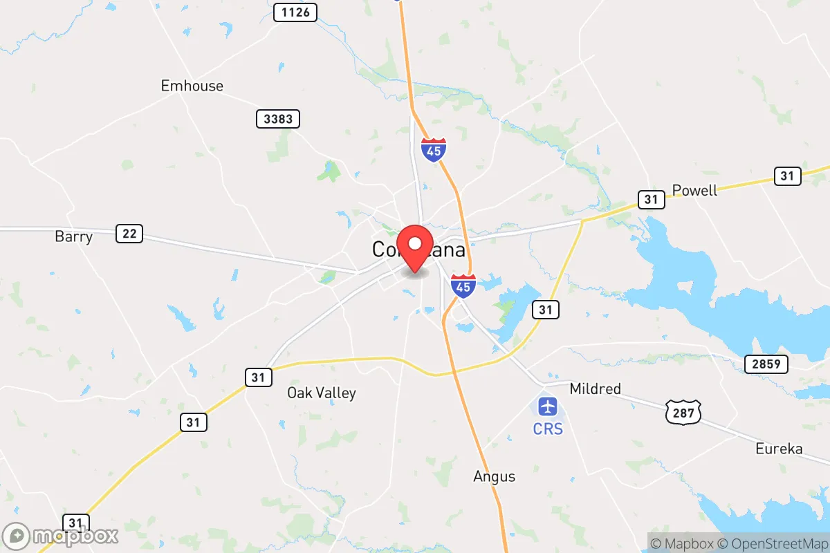
Key Distances
Regional Safe Places
Below is our recommended "safe zones" in Texas and the surrounding area based on our strategic heuristics. For most people, it's unrealistic to live in a “safe zone” full-time due to work, family or other personal reasons. They tend to be more rural. However, many of these areas are perfect for second homes and retreat properties that double as a vacation home or even a short-term rental.


Important Note: For informational purposes only. This does not mean nothing bad ever happens in the green zones. Please use common sense. This is based on public data and modeled with AI. We tried to take a conservative approach but mistakes happen. We update this regularly as new information becomes available.
Solar Generator Recommendations
Backup power matters more here than in safer locations. We've picked three solar generators across budgets and capacity tiers — start with the budget unit if you only need a few essentials, or step up if you want to run a fridge and HVAC for days at a time.

Jackery Portable Power Station Explorer 300
Budget OptionPower on the Go: Weighing only 11 lbs, it's convenient to set up and store with book-sized foldable solar panels

BLUETTI Portable Power Station AC180
Designed for both indoor and outdoor scenarios, AC180 is highly capable as it has a robost capacity and continuous output power.

EF ECOFLOW DELTA Pro Ultra Power Station
Upgraded PickEcoFlow DELTA Pro Ultra is a whole-home energy system designed to grow with your family. Integrated with the Smart Home Panel 2, it scales to meet your evolving energy needs — keeping your home powered, intelligent, and secure through every stage of life.
We earn a commission, at no additional cost to you.
Strategic Assessment Analysis
Corsicana, Texas, presents a mixed bag for the strategic relocator. While its location 55 miles south of Dallas offers a degree of separation from a major metropolitan target, it is not remote enough to be considered a true bug-out location, nor is it far enough from the Interstate 35 and 45 corridors to avoid the flow of displaced populations during a crisis. The town’s historical resilience, rooted in the 1890s oil boom and a modern shift toward manufacturing and logistics, gives it a working-class backbone, but its proximity to high-value infrastructure and demographic pressures demand a sober assessment.
Geographic position and natural advantages and the Corsicana position
Corsicana sits in the Post Oak Savannah, a transitional eco-region that offers better water retention and more reliable rainfall than points west. The land is gently rolling, not mountainous, which means it is arable but offers little in the way of natural defensive terrain. The town’s position at the intersection of US Highway 287 and State Highway 31 provides decent east-west and north-south movement, but these same roads become liabilities during an evacuation. The proximity to Richland-Chambers Reservoir (30 miles north) and Navarro Mills Lake (20 miles west) gives the area a genuine water security advantage over most of Texas. These are not small to the region what a reliable surface water supply that is not dependent on the Ogallala Aquifer, which is a long-term strategic plus. The soil is suitable for small-scale agriculture, and the growing season is long, which matters for anyone planning to supplement food stores with gardening or livestock.
Risks, exposures, and proximity to fallout-relevant landmarks
The single biggest strategic liability for Corsicana is its position relative to the Dallas-Fort Worth metroplex. Fifty-five miles is not a target itself, but it sits directly in the path of any southbound evacuation traffic on I-45. During a major event that empties Dallas—whether a natural disaster, a grid collapse, or a civil unrest scenario—Corsicana will see a wave of refugees before they ever reach Waco. The town is also within 90 miles of the Comanche Peak Nuclear Power Plant near Glen Rose. While a meltdown is a low-probability event, the prevailing winds in this region run south and east, meaning a plume could reach Navarro County within hours. The presence of a Union Pacific rail line running through the center of town is a double-edged sword: it is good for supply chains but also makes the town a potential chokepoint for hazmat spills or rail-borne disruptions. The Barnett Shale natural gas fields to the west mean there is a energy asset, but the associated infrastructure—pipelines, compressor stations, and processing plants—creates a non-trivial explosion and fire risk in the immediate area.
Practical resilience for a relocator: food, water, energy, energy, and defensibility
For a prepper or survivalist, Corsicana offers a few genuine strengths and some serious gaps. On the plus side, the local economy is not purely dependent on one sector. With over 20 industrial employers, a FedEx Ground hub, and a strong agricultural base in corn, sorghum, cotton, and cattle, the town has a real goods-producing economy. This means that during a supply chain disruption, local stores and markets are more likely to have basic necessities than a bedroom community. The Navarro Regional Hospital (85 beds) is adequate for routine emergencies but will be overwhelmed in a mass casualty event. For trauma care, you are looking at a 45-minute drive to Dallas or Waco, which is a hard no for anyone planning for a serious injury during a crisis. The Corsicana Independent School District serves about 5,500 students across eight elementary schools, two middle schools, and one high school. The district is not a standout academically, but it is functional. For parents who want their children will be in a system that is not under the same ideological pressures as urban districts. Navarro College provides a local option for job training or dual-credit courses, which is a small but real asset for families. The town’s water supply from Richland-Chambers and Navarro Mills is a major strategic advantage. Most of Texas is not dependent on a single pipeline or well field, which is vulnerable to contamination or failure. For energy, the proximity to natural gas fields and multiple gas-fired power plants means the grid here is less likely to go dark first, but it is still part of the ERCOT system, so a statewide blackout will hit here too. Solar and battery backup are strongly recommended.
The overall strategic picture for Corsicana is one of cautious utility. It is not a fortress, and it is not a remote homestead. It is a working-class town with real water security, a diversified economy, and a conservative political culture (Navarro County voted +48 R in 2020). But it is too close to Dallas to be safe from the fallout of a metropolitan collapse, and its position on major evacuation routes makes it a natural funnel for displaced populations. For a single individual or a family looking to relocate with a preemptively, Corsicana works best as a staging ground—a place to build skills, store supplies, and establish a network before moving further out. If you are looking for a place to ride out the storm, you need to go another 50 miles east or south. If you want a place to prepare for the storm, Corsicana is a viable option, provided you have a plan for the day the highways fill with people heading your way.
* Values derived from national, state, county, city and local statistics and may differ in a specific area. Last updated: 2026-05-14T18:15:56.000Z
Narrative content on this page is AI-generated and may contain mistakes. Verify any details that matter before acting on them.
ReloMaps may earn a commission from affiliate links at no extra cost to you.