

Photo: Wikipedia
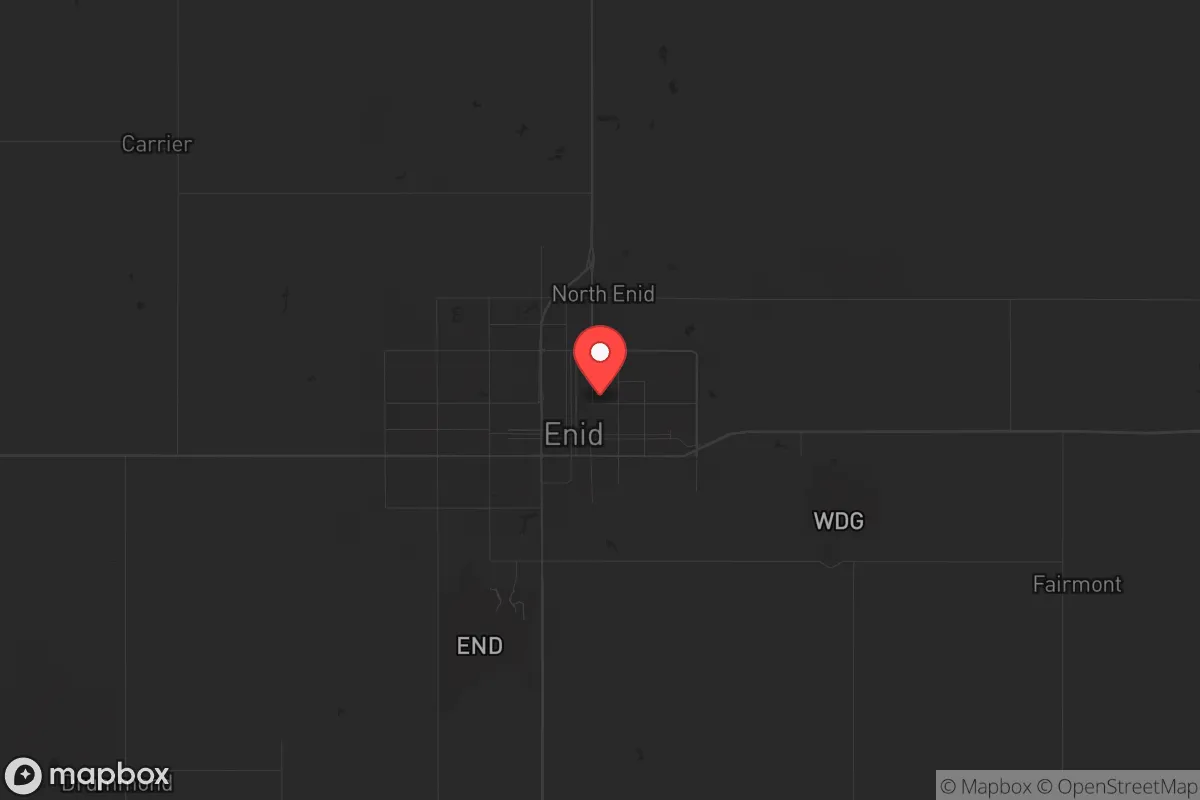
Strategic Assessment of Enid, OK
Workable tactical position. Some exposure to population density or targets, but generally defensible in a crisis.
What does the Strategic Assessment tell us?
Our Strategic Assessment grades tactical survivability of an area. Major population centers, military targets, fallout zones, natural disasters, and border exposure all drive risk — lower exposure means a more defensible position in a crisis.
This is heavily inspired by Joel Skousen's Strategic Relocation book. Highly recommended you checkout the book ($)What does this tell us?
Our Strategic Assessment grades tactical survivability of an area. Major population centers, military targets, fallout zones, natural disasters, and border exposure all drive risk — lower exposure means a more defensible position in a crisis.
This is heavily inspired by Joel Skousen's Strategic Relocation book. Highly recommended you checkout the book ($)Strategic Pillars

Key Distances
Regional Safe Places
Below is our recommended "safe zones" in Oklahoma and the surrounding area based on our strategic heuristics. For most people, it's unrealistic to live in a “safe zone” full-time due to work, family or other personal reasons. They tend to be more rural. However, many of these areas are perfect for second homes and retreat properties that double as a vacation home or even a short-term rental.
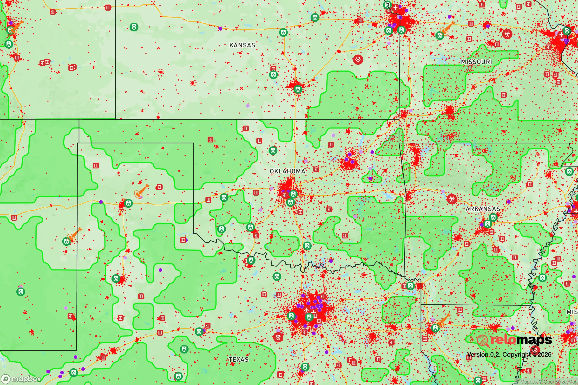
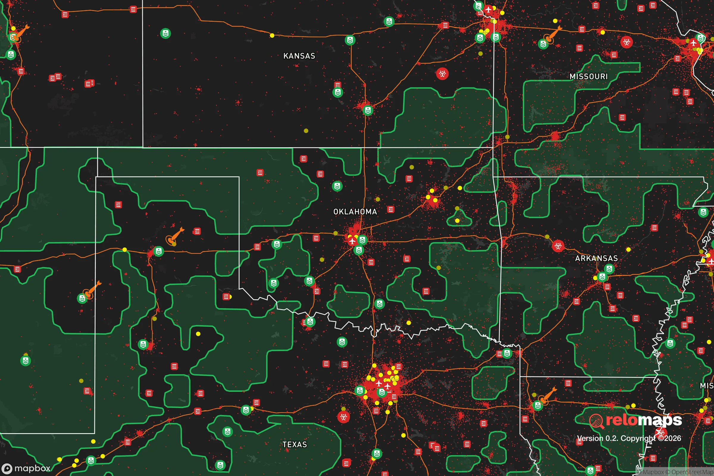
Important Note: For informational purposes only. This does not mean nothing bad ever happens in the green zones. Please use common sense. This is based on public data and modeled with AI. We tried to take a conservative approach but mistakes happen. We update this regularly as new information becomes available.
Solar Generator Recommendations
Backup power matters more here than in safer locations. We've picked three solar generators across budgets and capacity tiers — start with the budget unit if you only need a few essentials, or step up if you want to run a fridge and HVAC for days at a time.

Jackery Portable Power Station Explorer 300
Budget OptionPower on the Go: Weighing only 11 lbs, it's convenient to set up and store with book-sized foldable solar panels

BLUETTI Portable Power Station AC180
Designed for both indoor and outdoor scenarios, AC180 is highly capable as it has a robost capacity and continuous output power.

EF ECOFLOW DELTA Pro Ultra Power Station
Upgraded PickEcoFlow DELTA Pro Ultra is a whole-home energy system designed to grow with your family. Integrated with the Smart Home Panel 2, it scales to meet your evolving energy needs — keeping your home powered, intelligent, and secure through every stage of life.
We earn a commission, at no additional cost to you.
Strategic Assessment Analysis
Enid, Oklahoma, sits as a surprisingly resilient node in the Great Plains, offering a strategic blend of agricultural self-sufficiency, industrial depth, and geographic isolation that appeals to those preparing for systemic instability. Located in north-central Oklahoma, roughly 90 miles northwest of Oklahoma City and 60 miles south of the Kansas border, Enid benefits from being far enough from major metropolitan centers to avoid the immediate fallout of urban collapse, yet close enough to access regional logistics and medical infrastructure if needed. The city’s economy is anchored by Vance Air Force Base, a major pilot training facility, and a robust agricultural and energy sector, giving it a dual foundation of federal stability and local resource production. For a conservative-leaning relocator prioritizing self-reliance and community cohesion, Enid presents a credible option—but it’s not without its own vulnerabilities that demand careful consideration.
Geographic position and natural advantages for long-term stability
Enid’s location in the southern Great Plains provides several natural advantages for those seeking a buffer from coastal and urban chaos. The city sits on the edge of the Central Flyway, with abundant waterfowl and game for hunting, and the surrounding farmland is some of the most productive in the nation—wheat, corn, soybeans, and cattle dominate the landscape. The terrain is flat to gently rolling, which limits defensible chokepoints but also offers clear lines of sight and open ground for agriculture. The climate is semi-arid, with hot summers and cold winters, but annual precipitation averages around 33 inches, enough to support dryland farming without heavy reliance on irrigation. Enid is also situated near the Salt Fork of the Arkansas River, providing a surface water source, though the region’s groundwater from the Ogallala Aquifer is a critical but finite resource. The area’s low population density—Garfield County has roughly 62,000 people—means less competition for resources in a crisis, and the lack of major interstate highways (I-35 is 40 miles east) reduces the risk of mass migration flows through the city. For a relocator, this geographic isolation is a double-edged sword: it offers security from urban unrest but also limits rapid resupply if supply chains fracture.
Risks, exposures, and proximity to fallout-relevant landmarks
No strategic assessment is complete without a hard look at what could go wrong, and Enid has several exposure points that a prepper must weigh. The most obvious is Vance Air Force Base, which houses the 71st Flying Training Wing and is a primary training site for the U.S. Air Force’s T-6 Texan II, T-38 Talon, and T-1 Jayhawk aircraft. While the base provides economic stability and a military presence that could aid in local security, it also makes Enid a potential target for any adversary seeking to disrupt U.S. pilot training. In a major conflict or terrorist event, the base could draw precision strikes or become a focal point for civil unrest if the military is called to domestic roles. Additionally, Enid is within 150 miles of the Pantex Plant near Amarillo, Texas, the nation’s primary nuclear weapons assembly and disassembly facility. A catastrophic event at Pantex—whether accident or attack—could produce fallout that reaches Enid depending on wind patterns, though prevailing winds tend to blow west to east, pushing contamination toward Oklahoma City and beyond. The city is also roughly 200 miles from the Wichita Mountains and the Fort Sill military complex, another potential target. On the natural disaster front, Enid sits in Tornado Alley, with a history of violent EF4 and EF5 tornadoes—the 2010 tornado that struck nearby Piedmont is a reminder that severe weather is a recurring threat. Flooding is less of a concern due to the flat terrain, but flash floods from intense storms can occur. For a relocator, the key takeaway is that Enid’s military and energy infrastructure creates a moderate risk profile, but its distance from major population centers (Oklahoma City, Wichita, Tulsa) means it’s unlikely to face the cascading failures of a densely populated urban collapse.
Practical resilience for a relocator: food, water, energy, and defensibility
For someone serious about self-sufficiency, Enid offers a strong baseline but requires active preparation. Food production is the area’s standout advantage: the surrounding Garfield County is a top wheat producer, and local farmers’ markets, co-ops, and bulk grain suppliers are accessible. Hunting and fishing are viable, with public lands like the Great Salt Plains State Park (30 miles east) providing waterfowl and deer, though competition from other hunters will spike in a crisis. Water security is more nuanced. The city’s municipal water comes from the Kaw Lake pipeline (about 50 miles east), which is vulnerable to disruption from power grid failure or sabotage. Private wells are an option, but the Ogallala Aquifer is depleting at an alarming rate—some estimates suggest 30% of its capacity is already gone. A relocator should plan for rainwater catchment and storage, as annual rainfall is reliable but not abundant. Energy resilience is mixed: Enid has a strong natural gas infrastructure (Oklahoma is a top producer), and the local grid is served by Oklahoma Gas and Electric, which has a decent reliability record. Solar potential is good, with over 230 sunny days per year, but winter cloud cover can reduce output. Wood heating is feasible, with ample timber along the Salt Fork River, but the flat landscape means windbreaks are minimal. Defensibility is the weakest link. Enid is a spread-out city of about 50,000, with a grid-like street pattern that offers few natural chokepoints. The lack of hills, forests, or rivers that can serve as barriers means a determined group could move through the area easily. However, the strong agricultural community and conservative culture—many residents are armed, and the county has a high rate of gun ownership—create a social deterrent. Building a network of like-minded neighbors is essential; isolation in Enid is a liability, not a strength. For a single individual or family, a rural property on the outskirts (within 10-15 miles of town) offers better defensibility, with access to farmland and fewer entry points.
The overall strategic picture for Enid is one of moderate resilience with clear trade-offs. It’s not a hardened bunker location like the remote Rockies or the Ozarks, but it offers a functional middle ground for those who want to stay connected to regional infrastructure while avoiding the worst of urban decay. The city’s agricultural base, military presence, and conservative social fabric provide a foundation for community-based survival, but the risks from tornadoes, water depletion, and proximity to military targets cannot be ignored. For a relocator willing to invest in water storage, renewable energy, and local networking, Enid can serve as a viable long-term base—provided they accept that no location is truly safe, only better prepared. The key is to treat Enid not as a final destination, but as a platform for building resilience in a world that’s increasingly uncertain.
* Values derived from national, state, county, city and local statistics and may differ in a specific area. Last updated: 2026-04-21T11:41:21.000Z
Narrative content on this page is AI-generated and may contain mistakes. Verify any details that matter before acting on them.
ReloMaps may earn a commission from affiliate links at no extra cost to you.