
Photo: Wikipedia
Strategic Assessment of Gainesville, GA
Workable tactical position. Some exposure to population density or targets, but generally defensible in a crisis.
What does the Strategic Assessment tell us?
Our Strategic Assessment grades tactical survivability of an area. Major population centers, military targets, fallout zones, natural disasters, and border exposure all drive risk — lower exposure means a more defensible position in a crisis.
This is heavily inspired by Joel Skousen's Strategic Relocation book. Highly recommended you checkout the book ($)What does this tell us?
Our Strategic Assessment grades tactical survivability of an area. Major population centers, military targets, fallout zones, natural disasters, and border exposure all drive risk — lower exposure means a more defensible position in a crisis.
This is heavily inspired by Joel Skousen's Strategic Relocation book. Highly recommended you checkout the book ($)Strategic Pillars

Key Distances
Regional Safe Places
Below is our recommended "safe zones" in Georgia and the surrounding area based on our strategic heuristics. For most people, it's unrealistic to live in a “safe zone” full-time due to work, family or other personal reasons. They tend to be more rural. However, many of these areas are perfect for second homes and retreat properties that double as a vacation home or even a short-term rental.


Important Note: For informational purposes only. This does not mean nothing bad ever happens in the green zones. Please use common sense. This is based on public data and modeled with AI. We tried to take a conservative approach but mistakes happen. We update this regularly as new information becomes available.
Solar Generator Recommendations
Backup power matters more here than in safer locations. We've picked three solar generators across budgets and capacity tiers — start with the budget unit if you only need a few essentials, or step up if you want to run a fridge and HVAC for days at a time.

Jackery Portable Power Station Explorer 300
Budget OptionPower on the Go: Weighing only 11 lbs, it's convenient to set up and store with book-sized foldable solar panels

BLUETTI Portable Power Station AC180
Designed for both indoor and outdoor scenarios, AC180 is highly capable as it has a robost capacity and continuous output power.

EF ECOFLOW DELTA Pro Ultra Power Station
Upgraded PickEcoFlow DELTA Pro Ultra is a whole-home energy system designed to grow with your family. Integrated with the Smart Home Panel 2, it scales to meet your evolving energy needs — keeping your home powered, intelligent, and secure through every stage of life.
We earn a commission, at no additional cost to you.
Strategic Assessment Analysis
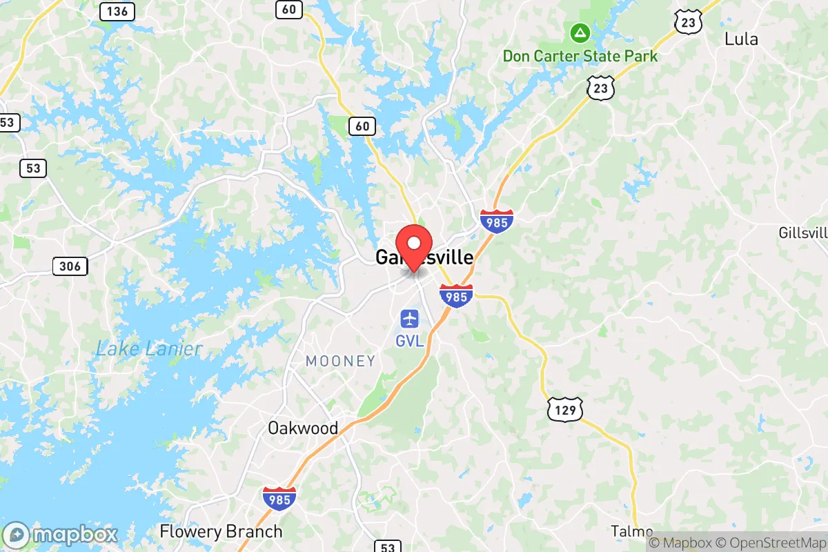
Gainesville, Georgia, often called the "Poultry Capital of the World," offers a surprisingly resilient strategic position for those prioritizing self-reliance and distance from major urban collapse zones. Nestled in the foothills of the Blue Ridge Mountains along the shores of Lake Lanier, this city of roughly 43,000 sits about 50 miles northeast of Atlanta—close enough for resource access but far enough to avoid the immediate fallout of a metropolitan crisis. For the conservative-minded relocator weighing civic unrest, supply chain disruptions, or natural disasters, Gainesville presents a mixed but workable picture: strong local food production, defensible terrain, and a politically aligned community, offset by real exposure to infrastructure choke points and a major dam that could become a liability.
Geographic position and natural advantages for long-term security
Gainesville’s location is its primary strategic asset. The city anchors the northeastern edge of the Atlanta metropolitan area, but the terrain quickly transitions into the Appalachian foothills, offering natural barriers and multiple escape routes into less populated counties like White, Lumpkin, and Union. The presence of Lake Lanier, a 38,000-acre reservoir created by the Buford Dam, provides a massive, defensible water source—though it also introduces a single-point-of-failure risk (more on that below). The surrounding Hall County is characterized by rolling hills, hardwood forests, and numerous creeks, which support decentralized water collection and concealment. Unlike flat, open regions, this topography makes large-scale surveillance or forced movement difficult, a key advantage during civil unrest. The climate is temperate, with four distinct seasons but no extreme weather patterns that would regularly threaten infrastructure; tornadoes are possible but not frequent, and the region is far enough inland to avoid hurricane storm surge. For a relocator seeking a buffer zone between the chaos of a major city and the isolation of deep wilderness, Gainesville occupies a Goldilocks zone—rural enough to breathe, connected enough to trade.
Risks, exposures, and proximity to fallout-relevant landmarks
The most glaring vulnerability in Gainesville’s strategic picture is its proximity to Buford Dam, the earthen dam that impounds Lake Lanier. Located roughly 10 miles southwest of downtown Gainesville, this dam is a high-value target for sabotage or could fail under a major seismic event (the region sits near the Eastern Tennessee Seismic Zone). A catastrophic dam failure would send a wall of water down the Chattahoochee River corridor, directly threatening downstream communities including much of Atlanta, but Gainesville itself sits above the dam on the lake’s northern end—meaning the city would not be flooded. However, the dam’s destruction would drain the lake, eliminating the primary water source and recreational economy, and likely trigger a mass evacuation of downstream areas, sending refugees northward into Hall County. That scenario is the single biggest localized risk. Additionally, Gainesville lies within 60 miles of Plant Hatch, a nuclear power plant in Baxley, Georgia, and about 100 miles from the Watts Bar Nuclear Plant in Tennessee. While not in the immediate fallout zone of a worst-case release, prevailing winds from the southwest could carry particulate matter toward the area. More immediate threats include the CSX and Norfolk Southern rail lines that run through Gainesville, carrying hazardous materials through the city center—a derailment or chemical release could disrupt the downtown core. For the prepper, the key takeaway is that Gainesville is not a remote bunker; it’s a regional hub with real exposure to man-made and infrastructure risks that require active mitigation.
Practical resilience for a relocator: food, water, energy, and defensibility
Where Gainesville shines is in its local food production capacity. Hall County is the heart of Georgia’s poultry industry, with major processing plants from Pilgrim’s Pride, Koch Foods, and Mar-Jac Poultry employing thousands. In a prolonged disruption, this means protein availability is far higher than in most U.S. counties. The area also supports small-scale agriculture—farmers’ markets, roadside stands, and a growing number of homesteaders—so a relocator with land can tap into a network of local growers. Water is abundant from Lake Lanier and numerous creeks, but reliance on municipal supply is a vulnerability; a well or rainwater catchment system is strongly advised. The energy grid is served by Georgia Power, with natural gas and coal plants in the region, but the mountainous terrain can cause localized outages during ice storms. Solar is viable here, with roughly 215 sunny days per year, though tree cover in the hills requires careful panel placement. Defensibility is moderate: the city itself is a grid of suburbs and strip malls, but the surrounding rural areas offer choke points on two-lane roads (e.g., GA-52, GA-115) that can be monitored or blocked. The local culture is heavily conservative, with a strong church and volunteer fire department presence, meaning community cohesion is higher than in urban centers—a critical factor for mutual aid during a crisis. For a single individual or family, the practical advice is to secure property north of the city, away from the lake’s recreational zones, and establish relationships with local farmers and gun clubs (Hall County has a robust firearms culture).
Overall, Gainesville presents a viable but not flawless strategic relocation option for the conservative prepper. It offers genuine advantages in food production, water access, and community alignment, while its proximity to Atlanta provides a buffer zone that can be leveraged for supply runs or intelligence gathering. The major downsides—dam risk, rail hazards, and the potential for refugee influx from the south—are manageable with proper planning, such as choosing a home on high ground with a well and maintaining a low profile. For those who want to be within striking distance of civilization but not consumed by it, Gainesville is a solid B+ choice. It won’t save you from a nuclear event or a complete societal collapse, but for the more likely scenarios of civil unrest, supply chain breakdowns, or localized disasters, it offers a defensible, resource-rich base of operations. Just keep an eye on that dam and have a bug-out route into the mountains ready.
* Values derived from national, state, county, city and local statistics and may differ in a specific area. Last updated: 2026-04-30T03:02:14.000Z
Narrative content on this page is AI-generated and may contain mistakes. Verify any details that matter before acting on them.
ReloMaps may earn a commission from affiliate links at no extra cost to you.