Photo: Wikipedia
Strategic Assessment of Grafton, WV
Meaningful friction. Expect exposure to either population pressure, blast zones, or natural disaster risk. Consider buying a retreat property.
What does the Strategic Assessment tell us?
Our Strategic Assessment grades tactical survivability of an area. Major population centers, military targets, fallout zones, natural disasters, and border exposure all drive risk — lower exposure means a more defensible position in a crisis.
This is heavily inspired by Joel Skousen's Strategic Relocation book. Highly recommended you checkout the book ($)What does this tell us?
Our Strategic Assessment grades tactical survivability of an area. Major population centers, military targets, fallout zones, natural disasters, and border exposure all drive risk — lower exposure means a more defensible position in a crisis.
This is heavily inspired by Joel Skousen's Strategic Relocation book. Highly recommended you checkout the book ($)Strategic Pillars

Key Distances
Regional Safe Places
Below is our recommended "safe zones" in West Virginia and the surrounding area based on our strategic heuristics. For most people, it's unrealistic to live in a “safe zone” full-time due to work, family or other personal reasons. They tend to be more rural. However, many of these areas are perfect for second homes and retreat properties that double as a vacation home or even a short-term rental.


Important Note: For informational purposes only. This does not mean nothing bad ever happens in the green zones. Please use common sense. This is based on public data and modeled with AI. We tried to take a conservative approach but mistakes happen. We update this regularly as new information becomes available.
Solar Generator Recommendations
Backup power matters more here than in safer locations. We've picked three solar generators across budgets and capacity tiers — start with the budget unit if you only need a few essentials, or step up if you want to run a fridge and HVAC for days at a time.

Jackery Portable Power Station Explorer 300
Budget OptionPower on the Go: Weighing only 11 lbs, it's convenient to set up and store with book-sized foldable solar panels

BLUETTI Portable Power Station AC180
Designed for both indoor and outdoor scenarios, AC180 is highly capable as it has a robost capacity and continuous output power.

EF ECOFLOW DELTA Pro Ultra Power Station
Upgraded PickEcoFlow DELTA Pro Ultra is a whole-home energy system designed to grow with your family. Integrated with the Smart Home Panel 2, it scales to meet your evolving energy needs — keeping your home powered, intelligent, and secure through every stage of life.
We earn a commission, at no additional cost to you.
Strategic Assessment Analysis
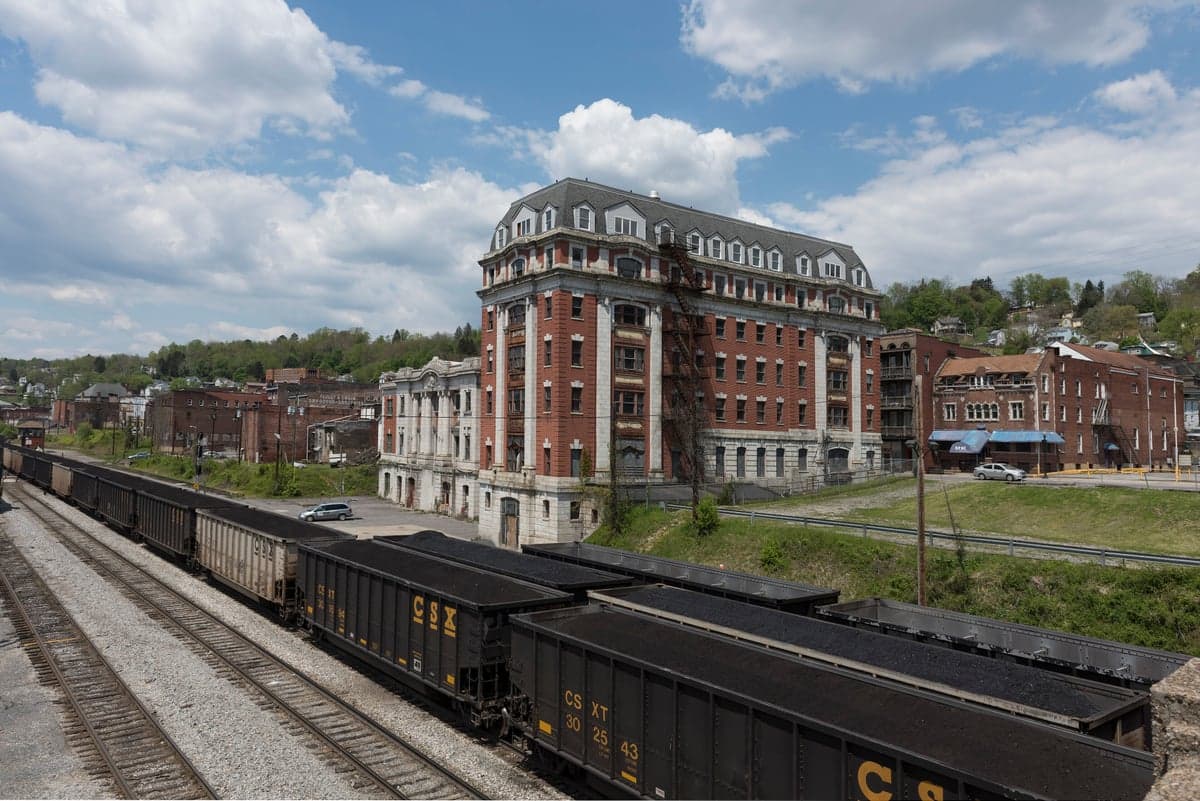
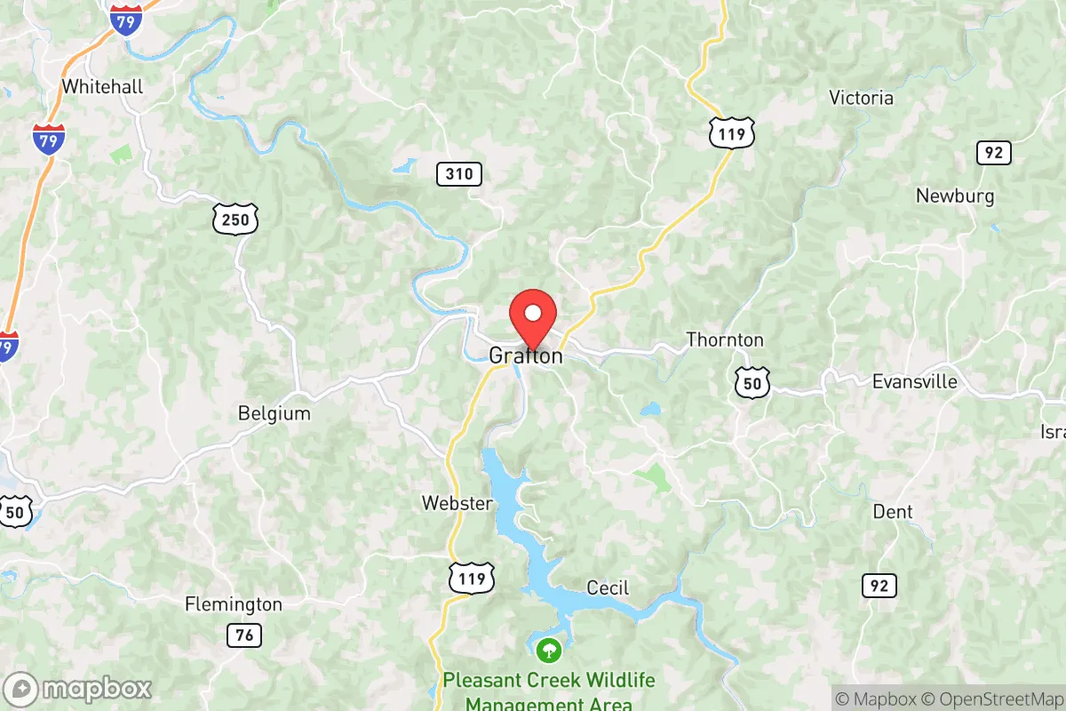
Grafton, West Virginia, sits in a sweet spot that few people outside the region have mapped: far enough from the chaos corridors of the Eastern Seaboard to avoid the worst of a collapse cascade, yet close enough to supply chains and medical infrastructure to keep a household running during a slow-motion crisis. This town of roughly 5,000 people, tucked into the Tygart Valley of Taylor County, offers a combination of geographic insulation, natural resource density, and low visibility that makes it a serious candidate for anyone thinking through a strategic relocation. The surrounding hills and hollows create a natural buffer against the kind of mass casualty events and civic unraveling that preppers track, while the local economy and community structure still function well enough to support a normal life—for now.
Geographic position and natural advantages for long-term security
Grafton sits at the confluence of the Tygart Valley River and Three Fork Creek, roughly 30 miles south of Morgantown and 45 miles east of Clarksburg. The terrain is classic Appalachian ridge-and-valley: steep wooded hills, narrow floodplains, and a handful of flat benches where the town itself is built. This topography is a defensive asset. The ridges funnel movement through predictable chokepoints, and the dense hardwood forest provides both cover and a renewable fuel source. The area sits well above the Ohio River floodplain, so the kind of catastrophic flooding that hits towns like Huntington or Wheeling is not a recurring threat here. The Tygart Valley River is a reliable water source, and the underlying geology includes multiple aquifers that support private wells in the surrounding county. For a relocator thinking about water security, that matters. The local growing season runs about 150 days, which is short but workable for a serious garden, and the surrounding national forest land—Monongahela National Forest is less than an hour east—offers hunting, foraging, and timber access that most suburban preppers never get to touch.
Risks, exposures, and proximity to fallout-relevant landmarks
No place is a fortress, and Grafton has its exposures. The town is about 90 miles from the Pittsburgh metro area, which in a major civil unrest scenario could send refugees filtering south along I-79 and US-50. That corridor is the primary risk vector. I-79 runs north-south about 10 miles west of town, and US-50 cuts east-west through the center of Grafton itself. In a mass evacuation event, those roads could become chokepoints or targets. The good news is that the local terrain makes it easy to bypass the main routes using county roads and forest service tracks—if you know the area. There are no nuclear power plants within a 50-mile radius, and the closest major industrial targets (chemical plants along the Ohio River, the Pittsburgh urban core) are far enough that fallout from a conventional or radiological event would likely be diluted or blocked by the intervening ridges. The biggest practical risk is economic: Taylor County has a poverty rate around 18%, and the local tax base is thin. If the national economy takes a serious hit, Grafton will feel it in reduced services and empty store shelves faster than a more diversified metro suburb. But that same economic marginality also means the town is not a high-value target for organized looting or strategic disruption. It is simply not important enough to attract attention.
Practical resilience for a relocator: food, water, energy, and defensibility
For someone serious about self-sufficiency, Grafton offers a realistic starting point. The Tygart Valley River runs through town and is fishable year-round, and the surrounding creeks and springs are numerous enough that a determined household could secure a gravity-fed water system without drilling a well. The local soil is acidic and rocky, but raised beds and contour planting work well on the hillsides. The growing season runs May through September, with a reliable frost-free window of about 140 days. That is enough for potatoes, beans, squash, tomatoes, and root vegetables, and the deer population is dense enough that a single freezer can be filled with venison each fall. Firewood is abundant and cheap—many locals still heat with wood as a primary source. Electricity comes from the regional grid, which is fed by coal and natural gas plants in the Ohio Valley, but solar is viable here: the area gets about 4.5 peak sun hours per day on average, and the hillsides offer south-facing slopes for panel placement. Defensibility is where Grafton really shines. The town itself is compact and walkable, but the surrounding hollows offer dozens of properties with single-road access, good sightlines, and natural barriers. A well-chosen property on a dead-end county road with a spring and a woodlot is about as close to a bug-in location as you can get without going completely off-grid. The local sheriff's office is understaffed—about 10 deputies for the whole county—so in a crisis, you are your own first responder. That is not a bug; it is a feature for anyone who has already accepted that reality.
The overall strategic picture for Grafton is one of moderate insulation with manageable trade-offs. It is not a prepper fantasyland—there is no underground bunker culture here, no militia compounds, no survivalist supply stores. What it offers is a functioning small town with a low profile, abundant natural resources, and a population that still remembers how to hunt, garden, and fix things. The nearest Level 1 trauma center is in Morgantown, about 40 minutes north, and the closest major grocery is a Walmart in Bridgeport, 20 minutes west. That is close enough for normal life but far enough that a supply chain disruption would not empty the shelves in Grafton overnight. For a conservative-leaning relocator who wants to be prepared for civic unrest, mass casualty events, or a slow-motion national unraveling, Grafton is a solid base of operations. It is not the most remote option in Appalachia, but it is one of the most practical—close enough to work a remote job or commute to a regional hub, far enough from the blast zones to sleep at night.
* Values derived from national, state, county, city and local statistics and may differ in a specific area. Last updated: 2026-05-01T21:36:50.000Z
Narrative content on this page is AI-generated and may contain mistakes. Verify any details that matter before acting on them.
ReloMaps may earn a commission from affiliate links at no extra cost to you.