
Photo: Wikipedia
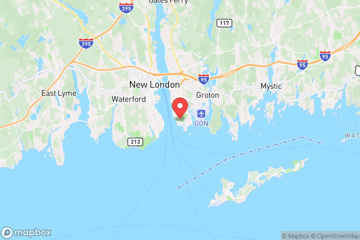
Strategic Assessment of Groton, CT
Multiple tactical vulnerabilities. Population density, target proximity, or disaster risk are likely compounding. A retreat property and exit planning is required.
What does the Strategic Assessment tell us?
Our Strategic Assessment grades tactical survivability of an area. Major population centers, military targets, fallout zones, natural disasters, and border exposure all drive risk — lower exposure means a more defensible position in a crisis.
This is heavily inspired by Joel Skousen's Strategic Relocation book. Highly recommended you checkout the book ($)What does this tell us?
Our Strategic Assessment grades tactical survivability of an area. Major population centers, military targets, fallout zones, natural disasters, and border exposure all drive risk — lower exposure means a more defensible position in a crisis.
This is heavily inspired by Joel Skousen's Strategic Relocation book. Highly recommended you checkout the book ($)Strategic Pillars

Key Distances
Regional Safe Places
Below is our recommended "safe zones" in Connecticut and the surrounding area based on our strategic heuristics. For most people, it's unrealistic to live in a “safe zone” full-time due to work, family or other personal reasons. They tend to be more rural. However, many of these areas are perfect for second homes and retreat properties that double as a vacation home or even a short-term rental.


Important Note: For informational purposes only. This does not mean nothing bad ever happens in the green zones. Please use common sense. This is based on public data and modeled with AI. We tried to take a conservative approach but mistakes happen. We update this regularly as new information becomes available.
Solar Generator Recommendations
Backup power matters more here than in safer locations. We've picked three solar generators across budgets and capacity tiers — start with the budget unit if you only need a few essentials, or step up if you want to run a fridge and HVAC for days at a time.

Jackery Portable Power Station Explorer 300
Budget OptionPower on the Go: Weighing only 11 lbs, it's convenient to set up and store with book-sized foldable solar panels

BLUETTI Portable Power Station AC180
Designed for both indoor and outdoor scenarios, AC180 is highly capable as it has a robost capacity and continuous output power.

EF ECOFLOW DELTA Pro Ultra Power Station
Upgraded PickEcoFlow DELTA Pro Ultra is a whole-home energy system designed to grow with your family. Integrated with the Smart Home Panel 2, it scales to meet your evolving energy needs — keeping your home powered, intelligent, and secure through every stage of life.
We earn a commission, at no additional cost to you.
Strategic Assessment Analysis
Groton, Connecticut, sits in a strategic paradox that demands serious consideration for anyone prioritizing long-term resilience. Its location on the Thames River estuary, just off Long Island Sound, offers access to marine resources and a degree of natural separation from the densest population corridors, yet its proximity to major defense infrastructure and metropolitan fallout zones creates a mixed risk profile. For a relocator thinking in terms of decades, not years, Groton’s value hinges on whether its advantages—submarine base, skilled workforce, coastal food sources—outweigh its exposure to the very systems that make it a target. This analysis strips away the real estate fluff and looks at Groton through the lens of practical survival, civic stability, and long-term defensibility.
Geographic position and natural advantages for long-term self-sufficiency
Groton’s geography is its strongest card, but it’s a card that requires careful play. The town occupies a peninsula between the Thames River and the coast, giving it direct access to tidal waters, shellfish beds, and marine protein that remain viable even if supply chains collapse. The Thames River itself is a navigable waterway that connects to the Long Island Sound and, by extension, the Atlantic—meaning a household with a small boat or kayak can access fishing grounds that most inland preppers cannot. The surrounding terrain is a mix of second-growth forest, wetlands, and rocky ridges, offering ample cover for dispersed retreats and natural water sources like the Poquonnock River and numerous small ponds. The climate is temperate, with reliable rainfall and a growing season long enough for cold-hardy crops like kale, potatoes, and root vegetables. However, the soil is thin and acidic in many areas—raised beds and soil amendment are non-negotiable for serious food production. The natural defensibility is moderate: the peninsula shape creates chokepoints on the few roads leading in and out, but the coastline is long and porous, making it vulnerable to waterborne approach. For a single individual or family willing to invest in perimeter awareness and watercraft, the position is workable. For someone expecting to hunker down without active security planning, the openness to the Sound is a liability.
Risks, exposures, and proximity to fallout-relevant landmarks
Here is where Groton’s strategic calculus gets uncomfortable. The town is home to Naval Submarine Base New London, one of the U.S. Navy’s primary submarine hubs, and General Dynamics Electric Boat, the shipyard that builds and overhauls nuclear-powered submarines. These facilities are not just economic engines—they are tier-one strategic targets in any conflict involving peer adversaries. A kinetic strike, cyber attack on the grid, or even a mass-casualty event at the base would ripple through Groton immediately. The base’s presence also means a high concentration of military personnel and defense contractors, which could be a stabilizing force during civil unrest—or a magnet for organized disruption, depending on the scenario. Additionally, Groton lies within roughly 50 miles of New York City and 100 miles of Boston, putting it inside the fallout zone of any major metropolitan disaster, whether nuclear, biological, or economic. The I-95 corridor, which runs through the town, is a primary evacuation route that would become a parking lot in a crisis. The Millstone Nuclear Power Station in nearby Waterford is another concern: while its safety record is solid, any incident there would place Groton in the plume zone. For a prepper, these exposures mean that Groton is not a bug-out location—it is a location that requires a bug-out plan. The smart play is to treat Groton as a base of operations with a pre-positioned secondary site inland, ideally in the Litchfield Hills or western Massachusetts, for when the risk profile tips.
Practical resilience for a relocator: food, water, energy, and defensibility
On the practical side, Groton offers a mixed bag that rewards preparation. Water is abundant—the Thames River is tidal but fresh enough upstream for treatment, and groundwater is accessible via wells in the more rural parts of town (check parcel records carefully, as many lots are on municipal water). Rainwater catchment is straightforward, with average annual precipitation around 50 inches. Food resilience is achievable but not automatic: the coastal waters provide clams, oysters, bluefish, and striped bass, but these require knowledge of tides, regulations, and processing. Local farmers’ markets and CSAs exist but are not robust enough to replace supply chains in a crisis—growing your own is essential. The town has a strong DIY culture thanks to the submarine workforce, meaning skilled tradespeople, welders, and mechanics are common, and hardware stores like Aubrey’s Hardware in Mystic are well-stocked. Energy is a vulnerability: the grid is aging and subject to storm outages (Hurricane Sandy and Tropical Storm Irene both caused multi-day blackouts). Solar with battery backup is a wise investment, but check local zoning—some HOAs and historic districts restrict panel placement. Defensibility at the household level is average: the town is suburban with mixed-density neighborhoods, so a property with good sightlines, a fenced perimeter, and a basement or storm shelter is worth a premium. The local police department is professional but small, and response times in the more rural eastern parts of town can stretch. For a relocator, the key is to buy on the periphery, not in the core—look at the areas near the Groton-Ledyard line or along the Poquonnock River, where lot sizes increase and neighbors are fewer. Avoid the areas directly adjacent to the base or Electric Boat, as those will be the first to experience congestion and scrutiny in a crisis.
The overall strategic picture for Groton is one of calculated risk with real upside for the prepared. It is not a sanctuary—the defense infrastructure and metropolitan proximity guarantee that it will be affected by national-level disruptions. But for a single individual or family willing to invest in a secondary retreat, maintain a low profile, and develop marine and agricultural skills, Groton offers a base with resources—water, food from the Sound, a skilled community—that many inland locations lack. The conservative prepper mindset values self-reliance and community competence, and Groton has both in spades, provided you are not relying on the government to save you. The submarine base and Electric Boat mean that many neighbors already think in terms of redundancy, security, and contingency—that culture is an asset. The bottom line: Groton works as a primary residence if you treat it as a forward operating base, not a final redoubt. Have a plan, have a secondary location, and never assume the coastline is safe just because it’s beautiful. Preparedness here is a lifestyle, not an afterthought.
* Values derived from national, state, county, city and local statistics and may differ in a specific area. Last updated: 2026-04-29T23:21:28.000Z
Narrative content on this page is AI-generated and may contain mistakes. Verify any details that matter before acting on them.
ReloMaps may earn a commission from affiliate links at no extra cost to you.