
Photo: Wikipedia
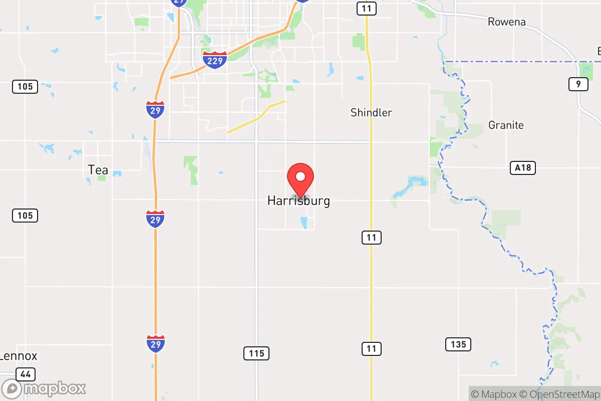
Strategic Assessment of Harrisburg, SD
Workable tactical position. Some exposure to population density or targets, but generally defensible in a crisis.
What does the Strategic Assessment tell us?
Our Strategic Assessment grades tactical survivability of an area. Major population centers, military targets, fallout zones, natural disasters, and border exposure all drive risk — lower exposure means a more defensible position in a crisis.
This is heavily inspired by Joel Skousen's Strategic Relocation book. Highly recommended you checkout the book ($)What does this tell us?
Our Strategic Assessment grades tactical survivability of an area. Major population centers, military targets, fallout zones, natural disasters, and border exposure all drive risk — lower exposure means a more defensible position in a crisis.
This is heavily inspired by Joel Skousen's Strategic Relocation book. Highly recommended you checkout the book ($)Strategic Pillars

Key Distances
Regional Safe Places
Below is our recommended "safe zones" in South Dakota and the surrounding area based on our strategic heuristics. For most people, it's unrealistic to live in a “safe zone” full-time due to work, family or other personal reasons. They tend to be more rural. However, many of these areas are perfect for second homes and retreat properties that double as a vacation home or even a short-term rental.


Important Note: For informational purposes only. This does not mean nothing bad ever happens in the green zones. Please use common sense. This is based on public data and modeled with AI. We tried to take a conservative approach but mistakes happen. We update this regularly as new information becomes available.
Solar Generator Recommendations
Backup power matters more here than in safer locations. We've picked three solar generators across budgets and capacity tiers — start with the budget unit if you only need a few essentials, or step up if you want to run a fridge and HVAC for days at a time.

Jackery Portable Power Station Explorer 300
Budget OptionPower on the Go: Weighing only 11 lbs, it's convenient to set up and store with book-sized foldable solar panels

BLUETTI Portable Power Station AC180
Designed for both indoor and outdoor scenarios, AC180 is highly capable as it has a robost capacity and continuous output power.

EF ECOFLOW DELTA Pro Ultra Power Station
Upgraded PickEcoFlow DELTA Pro Ultra is a whole-home energy system designed to grow with your family. Integrated with the Smart Home Panel 2, it scales to meet your evolving energy needs — keeping your home powered, intelligent, and secure through every stage of life.
We earn a commission, at no additional cost to you.
Strategic Assessment Analysis
Harrisburg, South Dakota, sits in a strategic sweet spot that few relocators fully appreciate: close enough to Sioux Falls for economic access, yet far enough to avoid the worst of a major urban collapse. The town’s position along the Big Sioux River and its location in a state with some of the nation’s most permissive firearm and property laws make it a compelling base for those thinking beyond the next election cycle. For a conservative-leaning individual or family weighing long-term resilience, Harrisburg offers a rare combination of small-town governance, agricultural self-sufficiency, and geographic insulation from the coastal chaos that increasingly defines American life.
Geographic position and natural advantages for long-term security
Harrisburg’s location in southeastern South Dakota places it in the heart of the Corn Belt, surrounded by some of the most productive farmland in the country. The Big Sioux River runs through the area, providing a reliable surface water source that can supplement well water for those who plan ahead. The town sits at roughly 1,400 feet elevation, with gently rolling terrain that offers natural drainage and limited flood risk compared to river-bottom communities further south. The climate is continental—cold winters, hot summers—but the absence of hurricane zones, earthquake faults, and wildfire corridors means the area faces fewer natural disaster variables than nearly any other region in the lower 48. For a prepper, that’s a baseline advantage: you’re not fighting geography on top of everything else. The surrounding Minnehaha and Lincoln counties are sparsely populated outside the Sioux Falls metro, meaning a collapse in the city would leave vast stretches of rural buffer between Harrisburg and any cascading unrest.
Risks, exposures, and proximity to fallout-relevant landmarks
No location is without vulnerabilities, and Harrisburg’s primary risk is its proximity to Sioux Falls—about 12 miles north. In a major civic unrest scenario, that distance is both a blessing and a curse. The city’s population of roughly 200,000 could become a source of looting, refugee flow, or resource competition if supply chains fail. However, the I-29 corridor that connects Sioux Falls to Harrisburg is a two-lane choke point in many sections, meaning a determined group could effectively screen traffic and control access. The Ellsworth Air Force Base near Rapid City is roughly 350 miles west, well outside any immediate fallout zone from a conventional strike, but the Minuteman III silos scattered across western South Dakota are a legitimate concern. A nuclear exchange targeting those silos would produce fallout that could drift eastward depending on wind patterns. Harrisburg sits about 200 miles east of the nearest silo field, which is far enough to reduce direct blast risk but close enough that a multi-day shelter-in-place plan with potassium iodide and HEPA filtration is prudent. The nearby Missouri River dams—Oahe, Big Bend, Fort Randall—are potential targets for sabotage or conventional attack, but their distance (over 100 miles west) means any dam failure would be a slow-moving flood event, not a sudden wall of water. The real risk here is less a single catastrophic event and more the slow unraveling of urban systems that would push desperate populations outward. Harrisburg’s defensibility lies in its rural character: low population density, limited road networks, and a community that still knows its neighbors.
Practical resilience for a relocator: food, water, energy, and defensibility
For someone serious about self-sufficiency, Harrisburg checks most boxes. The agricultural base means local food production is not a hobby but an industry—you can buy a quarter of beef directly from a rancher 20 minutes away, and the Sioux Falls Regional Livestock Market handles thousands of head weekly. The growing season runs roughly April through October, long enough for a serious garden, and the soil is rich glacial till that requires minimal amendment. Water is the critical variable. The Big Sioux River is a reliable surface source, but it’s also the receiving body for agricultural runoff and upstream wastewater. A well-drilled to the Dakota Aquifer (typically 100-200 feet deep in this area) provides clean, consistent water that doesn’t depend on municipal treatment plants. For energy, the region is increasingly wind-powered—South Dakota generates over 80% of its electricity from wind and hydro—but a grid-down scenario means solar panels with battery storage are the most practical backup. The flat terrain and frequent sunny days (about 210 sunny days per year) make solar viable even in winter, though snow cover requires occasional panel clearing. Defensibility is where Harrisburg shines. The town itself is laid out in a grid with limited entry points from the surrounding county roads. A small group could establish observation posts at the major intersections—Highway 115 and 42nd Street, for example—and maintain situational awareness of any approaching threats. The local sheriff’s office in Lincoln County is well-funded and pro-Second Amendment, and the state’s constitutional carry law means no permitting delays for those who move here. For a family, the public schools are rated above average, and the community’s conservative ethos means you’re unlikely to face hostility for stockpiling supplies or owning multiple firearms. The biggest practical gap is medical infrastructure: the nearest Level 1 trauma center is in Sioux Falls, and a major event would overwhelm it quickly. A relocator should plan for advanced first aid training and a stocked medical kit, because rural EMS response times can exceed 20 minutes.
The overall strategic picture for Harrisburg is one of calculated trade-offs. It’s not a remote mountain redoubt, and it’s not a coastal bunker. It’s a working agricultural town with a conservative population, decent infrastructure, and enough distance from major urban centers to buy time in a crisis. The proximity to Sioux Falls is the double-edged sword—it provides jobs and supplies now, but it could become a liability if the city collapses. For a relocator who wants to be part of a functioning community rather than a lone survivalist, Harrisburg offers a realistic middle path: you can live a normal life today while quietly building the capacity to weather whatever comes next. The land is affordable, the laws are favorable, and the people are the kind who still wave from their trucks. In a country that feels increasingly unmoored, that counts for more than most metrics can measure.
* Values derived from national, state, county, city and local statistics and may differ in a specific area. Last updated: 2026-04-19T04:24:08.000Z
Narrative content on this page is AI-generated and may contain mistakes. Verify any details that matter before acting on them.
ReloMaps may earn a commission from affiliate links at no extra cost to you.