Photo: Wikipedia
Strategic Assessment of Hempstead, NY
High tactical risk. This location is likely close to major population centers, strategic targets, or sits in a high-disaster corridor. A retreat property and careful exit planning is required.
What does the Strategic Assessment tell us?
Our Strategic Assessment grades tactical survivability of an area. Major population centers, military targets, fallout zones, natural disasters, and border exposure all drive risk — lower exposure means a more defensible position in a crisis.
This is heavily inspired by Joel Skousen's Strategic Relocation book. Highly recommended you checkout the book ($)What does this tell us?
Our Strategic Assessment grades tactical survivability of an area. Major population centers, military targets, fallout zones, natural disasters, and border exposure all drive risk — lower exposure means a more defensible position in a crisis.
This is heavily inspired by Joel Skousen's Strategic Relocation book. Highly recommended you checkout the book ($)Strategic Pillars

Key Distances
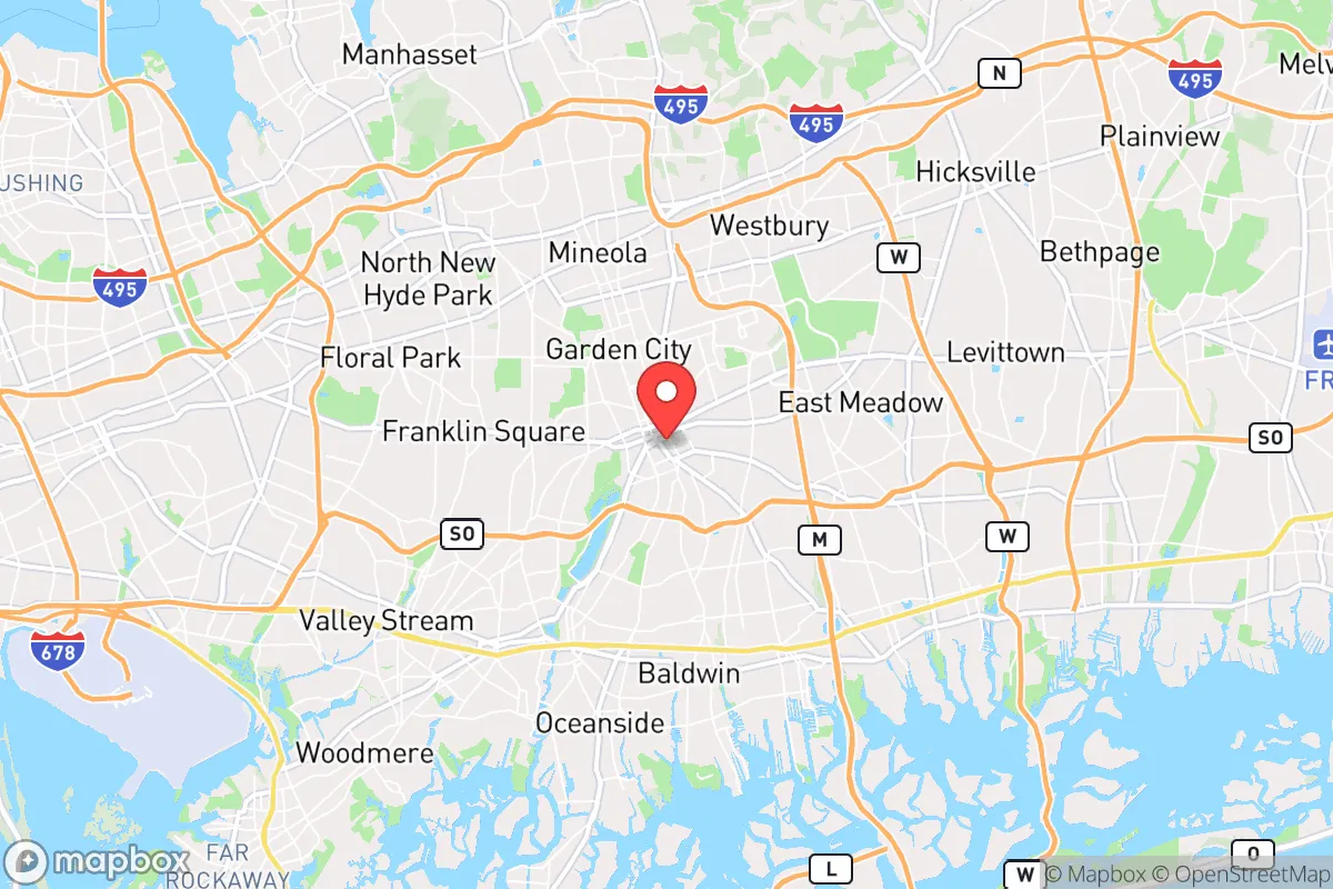
Regional Safe Places
Below is our recommended "safe zones" in New York and the surrounding area based on our strategic heuristics. For most people, it's unrealistic to live in a “safe zone” full-time due to work, family or other personal reasons. They tend to be more rural. However, many of these areas are perfect for second homes and retreat properties that double as a vacation home or even a short-term rental.


Important Note: For informational purposes only. This does not mean nothing bad ever happens in the green zones. Please use common sense. This is based on public data and modeled with AI. We tried to take a conservative approach but mistakes happen. We update this regularly as new information becomes available.
Solar Generator Recommendations
Backup power matters more here than in safer locations. We've picked three solar generators across budgets and capacity tiers — start with the budget unit if you only need a few essentials, or step up if you want to run a fridge and HVAC for days at a time.

Jackery Portable Power Station Explorer 300
Budget OptionPower on the Go: Weighing only 11 lbs, it's convenient to set up and store with book-sized foldable solar panels

BLUETTI Portable Power Station AC180
Designed for both indoor and outdoor scenarios, AC180 is highly capable as it has a robost capacity and continuous output power.

EF ECOFLOW DELTA Pro Ultra Power Station
Upgraded PickEcoFlow DELTA Pro Ultra is a whole-home energy system designed to grow with your family. Integrated with the Smart Home Panel 2, it scales to meet your evolving energy needs — keeping your home powered, intelligent, and secure through every stage of life.
We earn a commission, at no additional cost to you.
Strategic Assessment Analysis
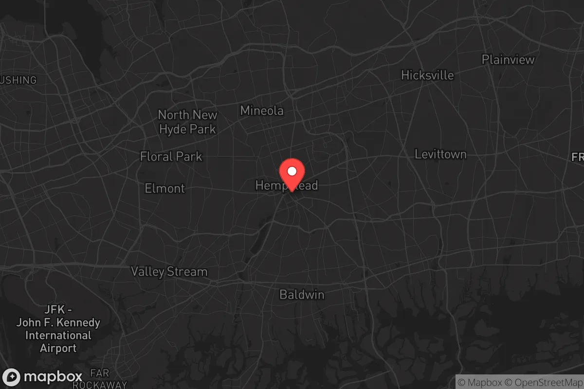
Hempstead, New York, sits in a precarious strategic position that demands a clear-eyed assessment for anyone serious about resilience and preparedness. While its location on Long Island offers proximity to major economic hubs, that same geography creates significant vulnerabilities for those prioritizing self-sufficiency and security in an unstable world. For the conservative-minded relocator concerned with civic unrest, mass casualty events, or systemic collapse, Hempstead presents a mixed picture—one where the advantages of infrastructure are heavily outweighed by the risks of density, exposure, and limited escape routes.
Geographic position and natural advantages for long-term survival
Hempstead’s location on the western half of Long Island places it roughly 20 miles east of Manhattan, a position that offers access to the Atlantic Ocean and the Long Island Sound. The area sits on a relatively flat coastal plain with sandy soils, which historically supported agriculture but now is almost entirely suburbanized. The moderate climate—with average winter lows around 25°F and summer highs near 85°F—means heating and cooling demands are manageable, but the region is prone to nor’easters and hurricane threats. The primary natural advantage is water access: the Atlantic provides a potential food source (fishing, shellfish) and a route for maritime evacuation or resupply, though this is offset by the fact that most shoreline is developed and heavily regulated. The area’s groundwater aquifer is a genuine asset, supplying most of Long Island’s drinking water, but it’s vulnerable to saltwater intrusion and contamination from the dense population above. For a relocator, the flat terrain offers no defensible high ground, and the lack of natural barriers means any unrest or disaster could spread quickly across the region.
Risks, exposures, and proximity to fallout-relevant landmarks
The most glaring strategic weakness of Hempstead is its proximity to New York City, a primary target for any large-scale attack, civil unrest, or cascading infrastructure failure. The town is within 25 miles of Manhattan’s financial district, several major airports (JFK, LaGuardia), and critical transportation hubs like the Long Island Rail Road and major highways (I-495, the Southern State Parkway). In a mass casualty event—whether from terrorism, a dirty bomb, or a biological release—Hempstead would be in the immediate fallout zone, both physically and logistically. The population density is extreme: Nassau County averages over 4,700 people per square mile, and Hempstead itself is one of the most densely populated towns in the U.S. This density creates a nightmare scenario for evacuation, as the road network is bottlenecked by bridges and tunnels leading off the island. The only egress points are the bridges and tunnels to the mainland, which would be choked with fleeing populations within hours of any major event. Additionally, the area hosts several potential secondary targets: the nearby Bethpage Naval Weapons Industrial Reserve Plant (a former defense facility) and the Long Island MacArthur Airport (a potential staging ground for military or relief operations). The Indian Point nuclear plant (though decommissioned) and the Brookhaven National Laboratory (a research facility with radioactive materials) are within 50 miles, adding another layer of risk for contamination events. For the prepper, Hempstead’s location is essentially a trap—a densely populated island with limited exits and multiple high-value targets within striking distance.
Practical resilience for a relocator: food, water, energy, and defensibility
On the ground, Hempstead offers a mixed bag for practical self-sufficiency. Food security is poor: the area is a food desert in terms of local agriculture, with most grocery stores relying on just-in-time supply chains from off-island distribution centers. There are a few community gardens and farmers’ markets, but they are insufficient for a sustained crisis. Water is a bright spot—the Magothy aquifer provides reliable groundwater, and many homes have private wells, though they require electricity to pump. Rainwater collection is feasible but limited by local regulations and the suburban lot sizes (typically 0.1–0.25 acres). Energy infrastructure is fragile: the grid is old and prone to outages during storms, and natural gas lines are widespread but vulnerable to disruption. Solar panels are a viable option, but Hempstead’s zoning and homeowners’ association rules can be restrictive, and the average home’s roof space is small. Defensibility is the weakest link: the suburban layout—with grid-like streets, minimal setbacks, and no natural chokepoints—makes it nearly impossible to secure a property against a determined group. The local law enforcement presence (Nassau County Police) is robust in normal times, but in a collapse scenario, they would be overwhelmed by the sheer population. The firearms culture is moderate; New York State has strict gun laws (requiring a permit for handguns and a background check for long guns), and magazine capacity is limited to 10 rounds. For a relocator, the practical takeaway is that Hempstead requires significant pre-positioning of supplies (food, water, fuel, medical gear) and a solid plan for evacuation rather than sheltering in place. The best-case scenario for a prepper here is a short-term disruption (a week or two of grid-down), not a long-term collapse.
In the final strategic assessment, Hempstead is a location that demands a hard look at trade-offs. For a single individual or family with a conservative, preparedness-minded outlook, the primary value is as a temporary staging point—a place to build resources and connections before moving to a more defensible location inland or upstate. The area’s economic opportunities (jobs in healthcare, education, and logistics) are real, but they come with the constant shadow of being in a high-risk zone. The smartest move for a relocator is to treat Hempstead as a base for networking and supply accumulation, not as a permanent retreat. If you’re serious about long-term resilience, look north to the Hudson Valley or west to the Appalachian foothills. Hempstead is a place to pass through, not to dig in.
* Values derived from national, state, county, city and local statistics and may differ in a specific area. Last updated: 2026-04-24T07:45:32.000Z
Narrative content on this page is AI-generated and may contain mistakes. Verify any details that matter before acting on them.
ReloMaps may earn a commission from affiliate links at no extra cost to you.