
Photo: Wikipedia
Strategic Assessment of Hickory, NC
Meaningful friction. Expect exposure to either population pressure, blast zones, or natural disaster risk. Consider buying a retreat property.
What does the Strategic Assessment tell us?
Our Strategic Assessment grades tactical survivability of an area. Major population centers, military targets, fallout zones, natural disasters, and border exposure all drive risk — lower exposure means a more defensible position in a crisis.
This is heavily inspired by Joel Skousen's Strategic Relocation book. Highly recommended you checkout the book ($)What does this tell us?
Our Strategic Assessment grades tactical survivability of an area. Major population centers, military targets, fallout zones, natural disasters, and border exposure all drive risk — lower exposure means a more defensible position in a crisis.
This is heavily inspired by Joel Skousen's Strategic Relocation book. Highly recommended you checkout the book ($)Strategic Pillars

Key Distances
Regional Safe Places
Below is our recommended "safe zones" in North Carolina and the surrounding area based on our strategic heuristics. For most people, it's unrealistic to live in a “safe zone” full-time due to work, family or other personal reasons. They tend to be more rural. However, many of these areas are perfect for second homes and retreat properties that double as a vacation home or even a short-term rental.


Important Note: For informational purposes only. This does not mean nothing bad ever happens in the green zones. Please use common sense. This is based on public data and modeled with AI. We tried to take a conservative approach but mistakes happen. We update this regularly as new information becomes available.
Solar Generator Recommendations
Backup power matters more here than in safer locations. We've picked three solar generators across budgets and capacity tiers — start with the budget unit if you only need a few essentials, or step up if you want to run a fridge and HVAC for days at a time.

Jackery Portable Power Station Explorer 300
Budget OptionPower on the Go: Weighing only 11 lbs, it's convenient to set up and store with book-sized foldable solar panels

BLUETTI Portable Power Station AC180
Designed for both indoor and outdoor scenarios, AC180 is highly capable as it has a robost capacity and continuous output power.

EF ECOFLOW DELTA Pro Ultra Power Station
Upgraded PickEcoFlow DELTA Pro Ultra is a whole-home energy system designed to grow with your family. Integrated with the Smart Home Panel 2, it scales to meet your evolving energy needs — keeping your home powered, intelligent, and secure through every stage of life.
We earn a commission, at no additional cost to you.
Strategic Assessment Analysis
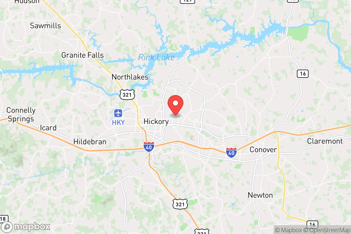
Hickory, North Carolina, sits in a strategic sweet spot that resilience-minded relocators should take seriously: far enough from major metropolitan targets to avoid the worst of any cascading collapse, yet close enough to tap into regional logistics and medical infrastructure when things are stable. The city’s position in the Catawba Valley, anchored by a diversified manufacturing base and a surprisingly robust local food system, gives it a resilience profile that outperforms most towns its size in the Southeast. For a conservative-leaning individual or family looking to hedge against civic unrest, supply chain disruptions, or natural disasters, Hickory offers a defensible, resource-rich base of operations—provided you understand its specific vulnerabilities and plan accordingly.
Geographic position and natural advantages for long-term stability
Hickory’s location in western North Carolina, roughly 50 miles northwest of Charlotte and 70 miles east of the Appalachian Mountains, places it in a corridor that historically avoids the worst of hurricane storm surge, coastal flooding, and the densest population corridors. The city sits at an elevation of around 1,100 feet, which moderates summer heat and reduces the risk of tornado touchdowns compared to the Piedmont flatlands. The surrounding Catawba County is laced with rivers, creeks, and the massive Lake Hickory—a 4,200-acre reservoir that provides a reliable surface water source independent of municipal treatment plants, assuming you have filtration capability. The area’s rolling hills and mixed hardwood-pine forests offer natural cover and defensible terrain, with numerous rural pockets where a prepared family could operate with low visibility. The Blue Ridge Mountains to the west act as a natural barrier against any large-scale movement from the Tennessee Valley, while the interstate system (I-40 runs directly through Hickory) gives you a viable evacuation route east toward the coast or west toward the mountains, depending on the scenario. For a prepper, the key takeaway is that Hickory is not a primary target—no major military bases, no nuclear power plants within 30 miles, no federal command centers—but it is close enough to Charlotte’s resources (airport, trauma centers, heavy equipment) to be useful in peacetime.
Risks, exposures, and proximity to fallout-relevant landmarks
No location is immune, and Hickory has several exposure points that a strategic relocator must account for. The most obvious is the McGuire Nuclear Station, located about 20 miles south of Hickory on Lake Norman. While the plant’s safety record is solid, a major incident—whether from sabotage, grid failure, or a natural disaster—could render a significant downwind zone uninhabitable for weeks or months. Prevailing winds in the region are from the southwest, meaning a plume from McGuire would push toward the Charlotte metro, not directly over Hickory, but a shift in weather patterns or a secondary event could change that calculus. Additionally, I-40 and I-77 intersect just east of Hickory, creating a chokepoint that could become a nightmare during a mass evacuation from Charlotte or the coast. In a scenario involving civil unrest or supply chain collapse, those highways would be clogged with refugees, making any attempt to leave the area by road slow and dangerous. The city itself has a population of roughly 44,000, with Catawba County at 160,000—dense enough that a localized disaster (chemical spill, pandemic outbreak, food riot) could overwhelm local resources quickly. There are no major military installations nearby, which is a double-edged sword: you avoid being a target, but you also lose the stabilizing presence of a garrison in a prolonged crisis. Finally, the region’s reliance on the Duke Energy grid means any widespread power outage—whether from cyberattack, solar flare, or physical sabotage—will hit Hickory hard, with rural areas potentially seeing restoration delays of weeks.
Practical resilience for a relocator: food, water, energy, and defensibility
For a family or individual serious about self-sufficiency, Hickory’s practical resilience metrics are mixed but workable. Water is the strongest asset: Lake Hickory, the Catawba River, and numerous smaller creeks provide ample surface water, and the water table in the area is high enough that a well-drilled to 200-300 feet will produce reliably. The city’s municipal water treatment plant draws from the Catawba River, but in a grid-down scenario, you’ll want your own pump and filtration—Berkey or Sawyer systems are standard recommendations for this region. Food resilience is decent but requires planning. The surrounding county has active farmland—dairy, poultry, and row crops like corn and soybeans—but most of it is tied to industrial agriculture, not small-scale permaculture. You’ll find local farmers’ markets and a few u-pick operations, but don’t expect to walk out your back door and forage. A serious prepper should plan to establish a garden and secure relationships with local growers before any crisis hits. Energy is the weak link. Hickory is fully dependent on the Duke Energy grid, and while there are some solar installations in the area, the cloud cover and tree canopy reduce solar yield compared to the Southwest. A backup generator with a 500-gallon propane tank is almost mandatory for anyone planning to stay through a multi-week outage. Defensibility is solid for a town of its size. The terrain offers natural chokepoints—bridges over the Catawba, narrow two-lane roads through the hills—that a prepared group could monitor or control. The local law enforcement presence is professional but small; Catawba County Sheriff’s Office has about 100 deputies, which means in a widespread event, you are largely on your own. The gun culture in the area is strong, with multiple ranges and gun shops, and the state’s permitless carry law (effective 2023) means you can legally carry without a license. That said, the local population is generally law-abiding and community-oriented, which reduces the risk of opportunistic violence compared to urban areas.
The overall strategic picture for Hickory is one of calculated trade-offs. It is not a remote bunker in the mountains—you will have neighbors, traffic, and the occasional Walmart run. But it is also not a high-risk target like Charlotte, Raleigh, or the coastal cities. For a conservative-leaning relocator who wants a base that can function in both normal times and crisis, Hickory offers a realistic middle ground: enough infrastructure to live comfortably, enough distance to avoid the worst fallout, and enough natural resources to sustain a prepared family through a prolonged disruption. The key is to treat it as a launch point, not a final redoubt. Stockpile supplies, build local networks, and keep a vehicle ready for a secondary move deeper into the mountains if the situation deteriorates beyond what the Catawba Valley can absorb. Done right, Hickory gives you a decade or more of stability in an unstable world—and that is more than most places can promise.
* Values derived from national, state, county, city and local statistics and may differ in a specific area. Last updated: 2026-04-21T17:14:29.000Z
Narrative content on this page is AI-generated and may contain mistakes. Verify any details that matter before acting on them.
ReloMaps may earn a commission from affiliate links at no extra cost to you.