
Photo: Wikipedia
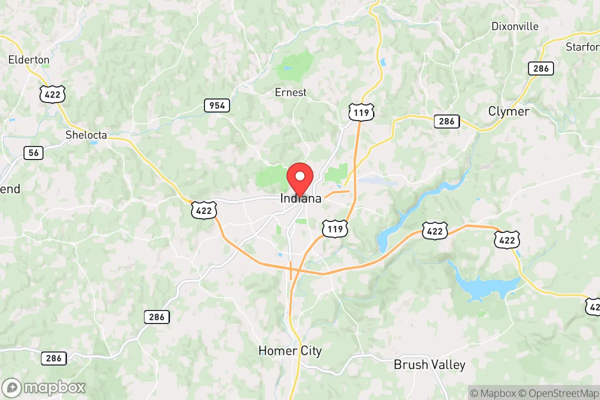
Strategic Assessment of Indiana, PA
Meaningful friction. Expect exposure to either population pressure, blast zones, or natural disaster risk. Consider buying a retreat property.
What does the Strategic Assessment tell us?
Our Strategic Assessment grades tactical survivability of an area. Major population centers, military targets, fallout zones, natural disasters, and border exposure all drive risk — lower exposure means a more defensible position in a crisis.
This is heavily inspired by Joel Skousen's Strategic Relocation book. Highly recommended you checkout the book ($)What does this tell us?
Our Strategic Assessment grades tactical survivability of an area. Major population centers, military targets, fallout zones, natural disasters, and border exposure all drive risk — lower exposure means a more defensible position in a crisis.
This is heavily inspired by Joel Skousen's Strategic Relocation book. Highly recommended you checkout the book ($)Strategic Pillars

Key Distances
Regional Safe Places
Below is our recommended "safe zones" in Pennsylvania and the surrounding area based on our strategic heuristics. For most people, it's unrealistic to live in a “safe zone” full-time due to work, family or other personal reasons. They tend to be more rural. However, many of these areas are perfect for second homes and retreat properties that double as a vacation home or even a short-term rental.


Important Note: For informational purposes only. This does not mean nothing bad ever happens in the green zones. Please use common sense. This is based on public data and modeled with AI. We tried to take a conservative approach but mistakes happen. We update this regularly as new information becomes available.
Solar Generator Recommendations
Backup power matters more here than in safer locations. We've picked three solar generators across budgets and capacity tiers — start with the budget unit if you only need a few essentials, or step up if you want to run a fridge and HVAC for days at a time.

Jackery Portable Power Station Explorer 300
Budget OptionPower on the Go: Weighing only 11 lbs, it's convenient to set up and store with book-sized foldable solar panels

BLUETTI Portable Power Station AC180
Designed for both indoor and outdoor scenarios, AC180 is highly capable as it has a robost capacity and continuous output power.

EF ECOFLOW DELTA Pro Ultra Power Station
Upgraded PickEcoFlow DELTA Pro Ultra is a whole-home energy system designed to grow with your family. Integrated with the Smart Home Panel 2, it scales to meet your evolving energy needs — keeping your home powered, intelligent, and secure through every stage of life.
We earn a commission, at no additional cost to you.
Strategic Assessment Analysis
Indiana, Pennsylvania offers a strategic blend of geographic insulation and practical resilience that appeals to those planning for long-term stability in an uncertain future. Located roughly 50 miles northeast of Pittsburgh and 85 miles west of Harrisburg, this borough of about 13,000 residents sits in the rolling hills of Indiana County, an area known for its rural character and modest population density. For a relocator with a survivalist or prepper mindset, the key advantage here is distance: Indiana is far enough from major metropolitan centers to avoid the immediate fallout of civic unrest or mass casualty events in cities like Pittsburgh, yet close enough to access medical and supply networks if needed. The area’s historical reliance on coal and natural gas extraction, combined with its position in the Appalachian foothills, provides natural barriers and resource access that many flatter, more exposed regions lack.
Geographic position and natural advantages for long-term security
Indiana County’s topography is a significant asset for those prioritizing defensibility and resource independence. The region is characterized by forested ridges, creek valleys, and limited major highways—primarily U.S. Route 422 and State Route 286—which naturally funnel traffic and make large-scale movement through the area difficult. This chokepoint geography is a double-edged sword: it can slow evacuation but also impedes any potential unrest or supply chain disruptions from spreading quickly. The county’s elevation, averaging around 1,300 feet, reduces flood risk compared to low-lying river towns, and the local climate supports four distinct seasons with adequate rainfall for agriculture. For a relocator, this means the land can sustain gardens and small-scale farming without heavy irrigation, a critical factor for food security in a grid-down scenario. The surrounding state game lands and forests, such as the 6,000-acre Yellow Creek State Park, offer hunting and foraging opportunities, though these are public resources that could become contested in a crisis.
Risks, exposures, and proximity to fallout-relevant landmarks
No location is without vulnerabilities, and Indiana’s proximity to certain infrastructure and population centers requires careful consideration. The most immediate risk is its 50-mile distance from Pittsburgh, a major metropolitan area of over 2.3 million people. In a mass casualty event or civil unrest scenario, Pittsburgh could become a source of displaced populations or secondary threats, though the intervening terrain and limited road networks would slow any exodus. More concerning is the presence of the Indian Point Nuclear Power Plant, located about 40 miles northwest near Shippingport, Pennsylvania. While not as large as some coastal reactors, any incident there could affect wind patterns across Indiana County, depending on prevailing weather. Additionally, the area sits within 100 miles of the Pittsburgh International Airport and several rail lines that transport hazardous materials, including crude oil from the Marcellus Shale region. For a prepper, these are not deal-breakers but demand a solid plan: maintaining a 72-hour bug-out kit, monitoring local emergency alerts, and having a secondary retreat location further east or south. The county’s low population density—about 87 people per square mile—reduces the risk of cascading social collapse compared to suburban sprawl, but the local economy’s dependence on a few industries (education, healthcare, and energy) means a prolonged disaster could strain resources.
Practical resilience for a relocator: food, water, energy, and defensibility
For a single individual or family looking to establish a resilient homestead, Indiana County offers several practical advantages. Water access is generally reliable: the area sits atop the Appalachian Plateau aquifer, and many rural properties have private wells with depths of 100-300 feet, providing a defensible water source independent of municipal systems. Surface water from creeks like the Little Mahoning Creek and Blacklegs Creek is available but requires filtration due to agricultural runoff and potential contamination. Energy independence is feasible thanks to the region’s history with coal and natural gas. While the coal industry has declined, natural gas extraction from the Marcellus Shale remains active, and some properties have access to gas wells or can install propane tanks. Solar potential is moderate—the area averages about 180 sunny days per year, less than the Southwest but sufficient for a well-designed off-grid system with battery storage. Wood heating is a strong option, given the abundant forests; a cord of seasoned hardwood costs around $200 locally, and many properties have existing wood stoves or fireplaces. Food production is viable with a growing season of roughly 150 days (May to October), suitable for cold-hardy crops like potatoes, kale, and root vegetables. Local farmers’ markets and co-ops, such as the Indiana County Farmers Market, provide backup supply chains, but a prepper should plan to store at least three months of non-perishables given the area’s distance from major distribution hubs. Defensibility is enhanced by the rural layout: many homes sit on dead-end roads or hillsides with clear sightlines, and the local sheriff’s office maintains a visible presence, though response times in remote areas can exceed 20 minutes. For those concerned about societal collapse, the community’s small-town character—where neighbors know each other and local churches and volunteer fire departments form social networks—can be a stabilizing force, but it also means outsiders may face scrutiny. Building trust through local involvement, such as joining a gun club or attending township meetings, is essential for long-term integration.
The overall strategic picture for Indiana, PA is one of moderate resilience with clear trade-offs. It is not a remote bunker location like parts of Montana or West Virginia, but it offers a practical middle ground for those who want to stay within a few hours of urban resources while maintaining a defensible, resource-rich base. The area’s natural barriers, water availability, and energy options make it a viable choice for a relocator willing to invest in off-grid infrastructure and community relationships. However, the proximity to Pittsburgh and the nuclear plant means that a comprehensive plan must include monitoring systems, multiple evacuation routes, and a mindset of constant readiness. For a conservative-leaning individual or family who values self-reliance and sees the current national trajectory as unstable, Indiana County provides a solid foundation—not a perfect fortress, but a place where preparation and common sense can go a long way toward weathering the storms ahead.
* Values derived from national, state, county, city and local statistics and may differ in a specific area. Last updated: 2026-05-01T08:33:18.000Z
Narrative content on this page is AI-generated and may contain mistakes. Verify any details that matter before acting on them.
ReloMaps may earn a commission from affiliate links at no extra cost to you.