Photo: Wikipedia
Strategic Assessment of Kennewick, WA
Workable tactical position. Some exposure to population density or targets, but generally defensible in a crisis.
What does the Strategic Assessment tell us?
Our Strategic Assessment grades tactical survivability of an area. Major population centers, military targets, fallout zones, natural disasters, and border exposure all drive risk — lower exposure means a more defensible position in a crisis.
This is heavily inspired by Joel Skousen's Strategic Relocation book. Highly recommended you checkout the book ($)What does this tell us?
Our Strategic Assessment grades tactical survivability of an area. Major population centers, military targets, fallout zones, natural disasters, and border exposure all drive risk — lower exposure means a more defensible position in a crisis.
This is heavily inspired by Joel Skousen's Strategic Relocation book. Highly recommended you checkout the book ($)Strategic Pillars

Key Distances
Regional Safe Places
Below is our recommended "safe zones" in Washington and the surrounding area based on our strategic heuristics. For most people, it's unrealistic to live in a “safe zone” full-time due to work, family or other personal reasons. They tend to be more rural. However, many of these areas are perfect for second homes and retreat properties that double as a vacation home or even a short-term rental.


Important Note: For informational purposes only. This does not mean nothing bad ever happens in the green zones. Please use common sense. This is based on public data and modeled with AI. We tried to take a conservative approach but mistakes happen. We update this regularly as new information becomes available.
Solar Generator Recommendations
Backup power matters more here than in safer locations. We've picked three solar generators across budgets and capacity tiers — start with the budget unit if you only need a few essentials, or step up if you want to run a fridge and HVAC for days at a time.

Jackery Portable Power Station Explorer 300
Budget OptionPower on the Go: Weighing only 11 lbs, it's convenient to set up and store with book-sized foldable solar panels

BLUETTI Portable Power Station AC180
Designed for both indoor and outdoor scenarios, AC180 is highly capable as it has a robost capacity and continuous output power.

EF ECOFLOW DELTA Pro Ultra Power Station
Upgraded PickEcoFlow DELTA Pro Ultra is a whole-home energy system designed to grow with your family. Integrated with the Smart Home Panel 2, it scales to meet your evolving energy needs — keeping your home powered, intelligent, and secure through every stage of life.
We earn a commission, at no additional cost to you.
Strategic Assessment Analysis
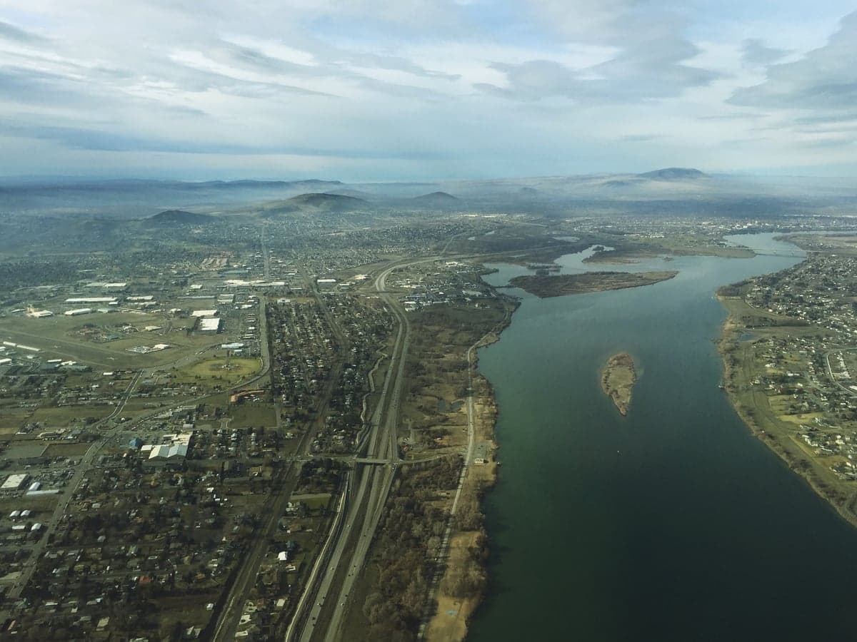
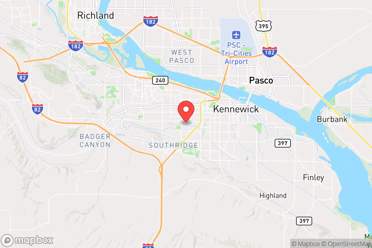
Kennewick, Washington, offers a strategic relocation option for those prioritizing resilience, due to its position in the Tri-Cities region—a semi-arid, inland area far from the coastal population centers and their associated vulnerabilities. The city sits at the confluence of the Columbia, Snake, and Yakima Rivers, providing a robust water supply and a geographic buffer against both Cascadia Subduction Zone tsunamis and the dense urban chaos of Seattle or Portland. For a prepper or survivalist, Kennewick’s combination of agricultural self-sufficiency, low population density relative to major metros, and a politically conservative culture makes it a defensible, resource-rich anchor point in a deteriorating national landscape.
Geographic position and natural advantages for long-term survival
Kennewick’s location in the Columbia Basin is a major asset for anyone thinking about long-term sustainability. The region receives less than 8 inches of annual rainfall, which means you’re not dealing with the mold, flooding, or constant cloud cover that plagues the western side of the state. Instead, you get over 300 days of sunshine—critical for solar panels, passive heating, and year-round gardening. The Columbia River, the largest river in the Pacific Northwest by volume, runs right through town, offering a virtually inexhaustible source of fresh water for drinking, irrigation, and even small-scale hydropower. The surrounding landscape is flat, open, and agricultural, with thousands of acres of irrigated farmland producing apples, grapes, corn, and alfalfa. This isn’t just a nice view; it’s a food-security buffer. If supply chains collapse, the Tri-Cities area can feed itself and its neighbors. The local economy is anchored by agriculture, the Hanford nuclear site, and Pacific Northwest National Laboratory—meaning there’s a steady base of skilled, stable employment that doesn’t rely on coastal tech or tourism. For a relocator, that translates to a community that’s less likely to empty out or panic when things go sideways.
Risks, exposures, and proximity to fallout-relevant landmarks
No strategic assessment is complete without acknowledging the elephant in the room: the Hanford Site, a decommissioned nuclear production facility located about 20 miles north of Kennewick. Hanford contains 56 million gallons of high-level radioactive waste in underground tanks, some of which are known to be leaking. In a worst-case scenario—a major earthquake, a terrorist attack, or a cascading infrastructure failure—a release of that material could render large portions of the Tri-Cities uninhabitable for generations. The prevailing winds blow from the southwest, so a plume from Hanford would likely move northeast, away from Kennewick proper, but the risk is real and should be factored into any relocation decision. Additionally, the Tri-Cities are within a two-hour drive of the Portland metro area (1.5 million people) and about three hours from Seattle (4 million people). In a mass evacuation event, both I-82 and I-84 would become choke points, and Kennewick could see a surge of refugees seeking food and shelter. The region also sits in a seismically active zone; while major quakes are rare, the 1872 magnitude 6.8 event near the area is a reminder that the ground can shake. Flooding from the Columbia is a minor concern—the Corps of Engineers manages dams upstream—but a catastrophic dam failure at Grand Coulee or Ice Harbor would be a different story. The bottom line: Kennewick’s risks are manageable with planning, but you need to have a Hanford-specific evacuation route and a plan for dealing with displaced urban populations.
Practical resilience for a relocator: food, water, energy, and defensibility
For a single individual or a family looking to harden their position, Kennewick offers practical advantages that are hard to beat. Water is the first priority, and the Columbia River provides a reliable, year-round source. You can pull water directly from the river with a simple pump and filter system—no need to rely on municipal supplies that could fail in a crisis. The high water table in the area also means shallow wells are viable for those with property outside city limits. Food production is straightforward: the growing season runs from April to October, and the soil, while sandy, responds well to irrigation and composting. Local farmers’ markets and U-pick operations are abundant, and the region’s status as a major agricultural hub means that even in a moderate disruption, food will be available longer than in most places. Energy resilience is strong: the Tri-Cities are served by the Bonneville Power Administration, which provides some of the cheapest hydroelectric power in the country. Solar panels work exceptionally well here due to the high sun hours, and net metering policies are favorable. For defensibility, Kennewick’s layout is a mixed bag. The city itself is spread out, with suburban neighborhoods and rural acreage just minutes from downtown. The best defensive posture is to buy property on the outskirts—think Finley, West Richland, or the Benton City area—where you have space, sightlines, and fewer neighbors. The local culture leans heavily conservative, with a strong emphasis on self-reliance, gun ownership, and community preparedness. That’s a double-edged sword: it means you’ll find like-minded people, but it also means you’re not the only one with a plan. Building a network of trusted locals is essential, not optional.
The overall strategic picture for Kennewick is one of calculated opportunity. It’s not a bug-out location in the wilderness—it’s a working, functioning city with infrastructure, jobs, and a community that doesn’t buy into coastal hysteria. The Hanford risk is real, but it’s a known variable that can be mitigated with a pre-planned evacuation route to the southeast (toward Walla Walla or Pendleton). The proximity to Portland and Seattle is a vulnerability, but it’s also a buffer: those cities will collapse inward before their populations can effectively migrate east in large numbers. For a conservative-leaning relocator who wants to be prepared for civic unrest, economic collapse, or natural disaster, Kennewick offers a rare combination of water security, agricultural self-sufficiency, energy independence, and a cultural alignment that values preparedness. It’s not paradise—nowhere is—but it’s a solid, defensible base from which to ride out the coming storms.
* Values derived from national, state, county, city and local statistics and may differ in a specific area. Last updated: 2026-04-21T17:23:29.000Z
Narrative content on this page is AI-generated and may contain mistakes. Verify any details that matter before acting on them.
ReloMaps may earn a commission from affiliate links at no extra cost to you.