
Photo: Wikipedia
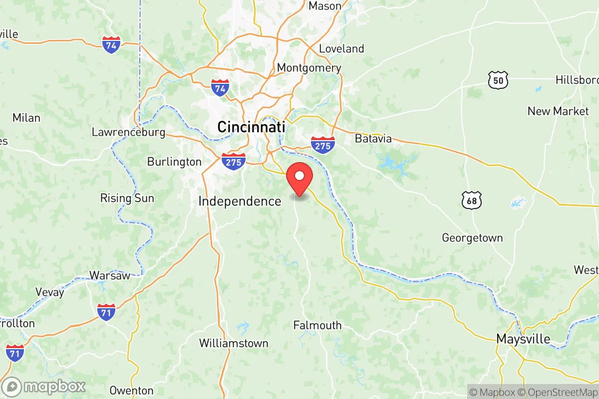
Strategic Assessment of Campbell County
Meaningful friction. Expect exposure to either population pressure, blast zones, or natural disaster risk. Consider buying a retreat property.
What does the Strategic Assessment tell us?
Our Strategic Assessment grades tactical survivability of an area. Major population centers, military targets, fallout zones, natural disasters, and border exposure all drive risk — lower exposure means a more defensible position in a crisis.
This is heavily inspired by Joel Skousen's Strategic Relocation book. Highly recommended you checkout the book ($)What does this tell us?
Our Strategic Assessment grades tactical survivability of an area. Major population centers, military targets, fallout zones, natural disasters, and border exposure all drive risk — lower exposure means a more defensible position in a crisis.
This is heavily inspired by Joel Skousen's Strategic Relocation book. Highly recommended you checkout the book ($)Strategic Pillars

Key Distances
Strategic Assessment Analysis
Campbell County, Kentucky, sits in a precarious but potentially strategic position for those prioritizing resilience and self-reliance. Its location along the Ohio River, directly across from Cincinnati, offers both a buffer from the worst of urban chaos and access to critical infrastructure, but it also places you within the blast radius of a major metropolitan target. For a relocator with a prepper mindset, this county demands a clear-eyed assessment: it’s not a remote redoubt, but it could serve as a viable fallback zone if you understand its specific risks and assets.
Geographic position and natural advantages for a resilient lifestyle
Campbell County’s geography is defined by the Ohio River and the Licking River, which converge near its northern edge. This water access is a double-edged sword: it provides a reliable water source for filtration and transport, but it also funnels traffic and potential threats. The county’s terrain is rolling hills and wooded valleys, offering some natural concealment and defensible positions, especially in the southern parts near Alexandria and Highland Heights. These areas sit on the uplands, away from the floodplains, giving you elevation advantages for observation and communication. The presence of Fort Thomas, a historic military post now largely residential, hints at the area’s past strategic importance—its hilltop positions still offer commanding views of the river valley. For a prepper, the key natural advantage is the Ohio River itself: a massive, renewable water source that can support long-term survival if you have the means to treat it. The surrounding farmland in southern Campbell County and neighboring Pendleton County provides a local food buffer, though you’ll need to secure your own supply chains.
Risks, exposures, and proximity to fallout-relevant landmarks
The most glaring risk is Campbell County’s proximity to Cincinnati, a major population center and likely target for any large-scale disruption—whether from civil unrest, EMP, or a coordinated attack. The county’s northern border is essentially the Cincinnati metro area, with Newport and Bellevue acting as suburban spillover. In a crisis, you’d face a wave of refugees from the city, and the bridges across the Ohio River—the Brent Spence Bridge and the Daniel Carter Beard Bridge—would become chokepoints or targets. Additionally, the county is within 50 miles of the Wright-Patterson Air Force Base in Dayton, a high-value military installation that could draw precision strikes or secondary effects. The Cincinnati/Northern Kentucky International Airport (CVG) is just across the river in Boone County, adding another potential target for disruption. On the industrial side, the Ohio River corridor is lined with chemical plants, refineries, and power stations—including the Miami Fort Power Station upstream—which could release hazardous materials if damaged. For a prepper, the takeaway is clear: Campbell County is not a safe distance from major targets. You’d need to plan for evacuation routes south or east, away from the river and into the more rural areas of Kentucky.
Practical resilience for a relocator: food, water, energy, and defensibility
For daily life and crisis scenarios, Campbell County offers a mixed bag. Water is abundant from the Ohio and Licking rivers, but you’ll need robust filtration—municipal supplies are vulnerable to contamination from upstream industrial accidents or sabotage. Well water is an option in the southern parts of the county, but test for agricultural runoff. Food security is moderate: the county has some local farms and farmers’ markets, particularly around Alexandria and Cold Spring, but it’s not a breadbasket. You’ll want to establish relationships with local growers or secure land for your own garden. Energy infrastructure is tied to the regional grid, which is vulnerable to cyberattacks or physical sabotage—consider solar panels with battery storage as a hedge. Defensibility varies by location. The hilltop neighborhoods of Fort Thomas offer natural chokepoints and good lines of sight, but they’re also dense and close to the river. The more rural areas near California (a small unincorporated community) and the southern border with Pendleton County provide better isolation, with winding roads and wooded cover. For a single individual or family, the ideal setup would be a property with a well, a garden, and a defensible perimeter, located at least 15 miles south of the Ohio River. The county’s conservative lean—historically red in local elections—means you’ll find like-minded neighbors, but don’t assume a unified community; the northern suburbs are more mixed politically.
The overall strategic picture for Campbell County is one of calculated risk. It’s not a remote survivalist paradise—you’re too close to Cincinnati and its associated threats. But for a relocator who wants to stay within a reasonable distance of work or family while maintaining a prepper lifestyle, it offers a workable middle ground. The key is to avoid the riverfront and the northern suburbs, and instead focus on the southern hill country where you can leverage the terrain and water access. You’ll need to invest in self-sufficiency—water filtration, off-grid power, and food storage—because the county’s infrastructure is fragile and tied to a vulnerable region. If you’re willing to accept that trade-off, Campbell County can be a defensible base for weathering the storm, as long as you have a plan to bug out further south if the situation escalates. It’s not a fortress, but it’s a solid forward operating position.
* Values derived from national, state, county, city and local statistics and may differ in a specific area. Last updated: 2026-05-13T08:42:12.000Z
Narrative content on this page is AI-generated and may contain mistakes. Verify any details that matter before acting on them.
ReloMaps may earn a commission from affiliate links at no extra cost to you.