
Photo: Wikipedia
Strategic Assessment of Kernersville, NC
Meaningful friction. Expect exposure to either population pressure, blast zones, or natural disaster risk. Consider buying a retreat property.
What does the Strategic Assessment tell us?
Our Strategic Assessment grades tactical survivability of an area. Major population centers, military targets, fallout zones, natural disasters, and border exposure all drive risk — lower exposure means a more defensible position in a crisis.
This is heavily inspired by Joel Skousen's Strategic Relocation book. Highly recommended you checkout the book ($)What does this tell us?
Our Strategic Assessment grades tactical survivability of an area. Major population centers, military targets, fallout zones, natural disasters, and border exposure all drive risk — lower exposure means a more defensible position in a crisis.
This is heavily inspired by Joel Skousen's Strategic Relocation book. Highly recommended you checkout the book ($)Strategic Pillars

Key Distances
Regional Safe Places
Below is our recommended "safe zones" in North Carolina and the surrounding area based on our strategic heuristics. For most people, it's unrealistic to live in a “safe zone” full-time due to work, family or other personal reasons. They tend to be more rural. However, many of these areas are perfect for second homes and retreat properties that double as a vacation home or even a short-term rental.


Important Note: For informational purposes only. This does not mean nothing bad ever happens in the green zones. Please use common sense. This is based on public data and modeled with AI. We tried to take a conservative approach but mistakes happen. We update this regularly as new information becomes available.
Solar Generator Recommendations
Backup power matters more here than in safer locations. We've picked three solar generators across budgets and capacity tiers — start with the budget unit if you only need a few essentials, or step up if you want to run a fridge and HVAC for days at a time.

Jackery Portable Power Station Explorer 300
Budget OptionPower on the Go: Weighing only 11 lbs, it's convenient to set up and store with book-sized foldable solar panels

BLUETTI Portable Power Station AC180
Designed for both indoor and outdoor scenarios, AC180 is highly capable as it has a robost capacity and continuous output power.

EF ECOFLOW DELTA Pro Ultra Power Station
Upgraded PickEcoFlow DELTA Pro Ultra is a whole-home energy system designed to grow with your family. Integrated with the Smart Home Panel 2, it scales to meet your evolving energy needs — keeping your home powered, intelligent, and secure through every stage of life.
We earn a commission, at no additional cost to you.
Strategic Assessment Analysis
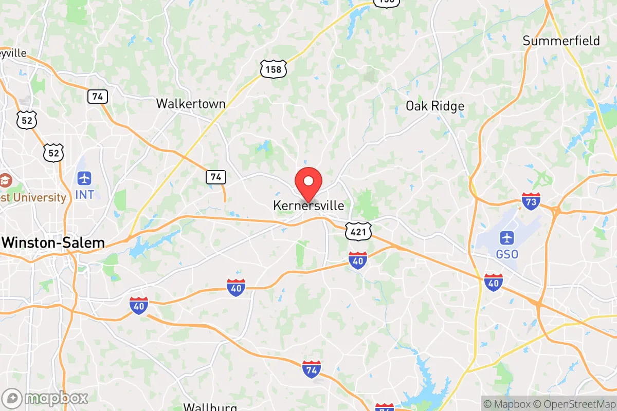
Kernersville, North Carolina, sits in a strategic sweet spot that resilience-minded relocators should take seriously: it’s far enough from the major metropolitan blast zones of Greensboro, Winston-Salem, and High Point to avoid the worst of a mass-casualty event or civil unrest cascade, yet close enough to access their resources if the grid holds. The town’s population hovers around 26,000, giving it a small-town feel with a built-in buffer of rural land to the north and west, while Interstate 40 and U.S. 421 provide evacuation routes that don’t funnel everyone through a single chokepoint. For a conservative-leaning individual or family looking to hedge against national instability, Kernersville offers a credible mix of geographic insulation, logistical access, and a community fabric that hasn’t yet been hollowed out by hyper-urbanization. The key question is whether its proximity to three mid-sized cities is a net asset or a liability when the lights go out.
Geographic position and natural advantages for long-term stability
Kernersville’s location at the junction of the Piedmont Triad gives it a rare combination of elevation and water access that preppers value. The town sits on a ridge line roughly 900 feet above sea level, which means it’s not in a floodplain—a critical advantage when hurricanes or prolonged rain events overwhelm low-lying areas like those along the Yadkin River to the west. The surrounding terrain is rolling hills with mixed hardwood forest, offering natural cover and defensible positions for those with rural property on the outskirts. The Piedmont region is also geologically stable; earthquake risk is negligible, and the area sees fewer tornado touchdowns than the central plains or the Gulf Coast. For a relocator concerned with long-term habitability, Kernersville’s climate is moderate—hot summers but no extreme cold snaps that would freeze pipes or kill off winter gardens, and annual rainfall around 45 inches that supports off-grid water catchment without the humidity of the Deep South. The soil in the surrounding county (Forsyth and northern Davidson) is loamy enough for small-scale agriculture, though it’s not the rich bottomland of the Midwest. If you’re planning to grow your own food after a disruption, you’ll need to amend the clay-heavy patches, but it’s doable with raised beds and compost.
Risks, exposures, and proximity to fallout-relevant landmarks
The biggest vulnerability for Kernersville is its proximity to three population centers that would become humanitarian disaster zones in a major crisis. Greensboro (pop. 300,000) is 20 miles east, Winston-Salem (pop. 250,000) is 15 miles west, and High Point (pop. 115,000) is 10 miles south. In a mass-casualty event—whether from a grid-down scenario, a biological outbreak, or coordinated civil unrest—those cities would generate refugee flows along I-40 and U.S. 421 directly through Kernersville. The town’s position as a transportation hub (I-40, U.S. 421, and U.S. 158 all converge here) means it would be a natural chokepoint for both evacuees and looters. There’s also a rail line running through the center of town (the Norfolk Southern mainline), which could become a target for sabotage or a vector for hazardous material spills. On the plus side, Kernersville is not near any nuclear power plants (the closest is Shearon Harris, 90 miles east near Raleigh) or major military installations that would be primary targets in a conflict. The Piedmont Triad International Airport (15 miles northeast) is a secondary concern—it’s not a major military airfield, but it could become a staging area for FEMA or National Guard operations that draw unwanted attention. For a survivalist, the risk calculus here is manageable if you have a plan to bug in or bug out quickly, but it’s not a remote hideaway. You’re betting that the town’s small size and rural fringe will let you ride out the first 72 hours while the cities burn through their own chaos.
Practical resilience for a relocator: food, water, energy, and defensibility
Kernersville’s practical resilience depends heavily on whether you’re inside the town limits or on the outskirts. Inside town, you’re on municipal water and grid power, which means you’re vulnerable to the same cascading failures that would hit any suburb. The town’s water supply comes from the Yadkin River via Winston-Salem’s system, so a contamination event upstream or a pump failure would leave you dry. Your first priority should be a 1,000-gallon rainwater catchment system and a Berkey filter—the clay soil doesn’t percolate well for well drilling in some neighborhoods, so don’t assume you can just dig a well. On the energy side, Duke Energy’s grid is aging but reliable in normal times; for off-grid backup, solar panels with battery storage are viable because the region gets about 210 sunny days per year, though winter cloud cover can stretch for a week at a time. A propane generator with a 500-gallon buried tank is the more conservative play. For food, the local farmers’ market (Kernersville Farmers Market, open April–November) is a good indicator of what grows well: tomatoes, peppers, squash, greens, and sweet potatoes. There are also several u-pick orchards within 15 minutes (e.g., J&L Farms in Oak Ridge) for apples and peaches. For long-term storage, the town has a Costco in Greensboro and a Walmart Supercenter locally, but both would be stripped within hours of a crisis—you need to have your own 6-month supply of grains, legumes, and canned goods before you move. Defensibility is mixed: the town’s layout is a typical grid with suburban sprawl, but the rural areas to the north (toward Stokes County) offer 5–10 acre parcels with tree lines and limited road access. If you’re buying, look for property on a dead-end road off NC-66 north of town, where you can control the approach. The local sheriff’s office (Forsyth County) is professional but understaffed—response times in the rural fringe can be 20–30 minutes, so you’re your own first responder.
The overall strategic picture for Kernersville is one of calculated trade-offs. It’s not a remote bunker location like the mountains of western North Carolina, and it won’t protect you from a direct nuclear strike or a nationwide grid collapse. But for a relocator who wants to stay within a few hours of family, maintain a professional job (the Triad has a strong manufacturing and logistics base), and still have a fighting chance when things go sideways, Kernersville offers a realistic middle ground. The town’s biggest asset is its community—still small enough that neighbors know each other, with a strong church presence and a local government that hasn’t been captured by progressive activism. The biggest liability is the transportation corridor that makes it a natural funnel for urban refugees. Your survival plan here needs to account for that: a bug-out route north into the Sauratown Mountains or west into the Uwharrie National Forest, a well-stocked pantry that doesn’t rely on local stores, and a social network of like-minded families who can form a mutual assistance group. If you’re willing to put in the work, Kernersville can be a solid base for riding out the storm—just don’t mistake it for a fortress. It’s a place to live strategically, not to hide.
* Values derived from national, state, county, city and local statistics and may differ in a specific area. Last updated: 2026-05-03T20:26:06.000Z
Narrative content on this page is AI-generated and may contain mistakes. Verify any details that matter before acting on them.
ReloMaps may earn a commission from affiliate links at no extra cost to you.