Photo: Wikipedia
Strategic Assessment of La Plata, MD
Meaningful friction. Expect exposure to either population pressure, blast zones, or natural disaster risk. Consider buying a retreat property.
What does the Strategic Assessment tell us?
Our Strategic Assessment grades tactical survivability of an area. Major population centers, military targets, fallout zones, natural disasters, and border exposure all drive risk — lower exposure means a more defensible position in a crisis.
This is heavily inspired by Joel Skousen's Strategic Relocation book. Highly recommended you checkout the book ($)What does this tell us?
Our Strategic Assessment grades tactical survivability of an area. Major population centers, military targets, fallout zones, natural disasters, and border exposure all drive risk — lower exposure means a more defensible position in a crisis.
This is heavily inspired by Joel Skousen's Strategic Relocation book. Highly recommended you checkout the book ($)Strategic Pillars

Key Distances
Regional Safe Places
Below is our recommended "safe zones" in Maryland and the surrounding area based on our strategic heuristics. For most people, it's unrealistic to live in a “safe zone” full-time due to work, family or other personal reasons. They tend to be more rural. However, many of these areas are perfect for second homes and retreat properties that double as a vacation home or even a short-term rental.


Important Note: For informational purposes only. This does not mean nothing bad ever happens in the green zones. Please use common sense. This is based on public data and modeled with AI. We tried to take a conservative approach but mistakes happen. We update this regularly as new information becomes available.
Solar Generator Recommendations
Backup power matters more here than in safer locations. We've picked three solar generators across budgets and capacity tiers — start with the budget unit if you only need a few essentials, or step up if you want to run a fridge and HVAC for days at a time.

Jackery Portable Power Station Explorer 300
Budget OptionPower on the Go: Weighing only 11 lbs, it's convenient to set up and store with book-sized foldable solar panels

BLUETTI Portable Power Station AC180
Designed for both indoor and outdoor scenarios, AC180 is highly capable as it has a robost capacity and continuous output power.

EF ECOFLOW DELTA Pro Ultra Power Station
Upgraded PickEcoFlow DELTA Pro Ultra is a whole-home energy system designed to grow with your family. Integrated with the Smart Home Panel 2, it scales to meet your evolving energy needs — keeping your home powered, intelligent, and secure through every stage of life.
We earn a commission, at no additional cost to you.
Strategic Assessment Analysis
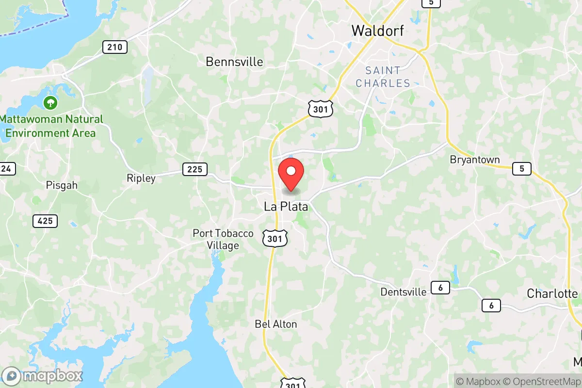
La Plata, Maryland, offers a surprisingly resilient position for those prioritizing strategic relocation, balancing proximity to the Chesapeake Bay region with a buffer from the immediate fallout zones of Washington, D.C. and Baltimore. Its location in Charles County places it roughly 35 miles south of the nation’s capital, a distance that provides a meaningful separation from the most likely epicenters of civil unrest, grid collapse, or targeted attacks, while still allowing access to critical infrastructure. For the prepper or survivalist, this isn’t a remote bunker—it’s a defensible, resource-rich staging area that leverages rural character and water access without being isolated from supply chains or medical evacuation routes.
Geographic position and natural advantages for long-term security
La Plata sits on the western edge of the Delmarva Peninsula, a geographic feature that inherently limits approach vectors—a key defensive consideration. The area is bounded by the Potomac River to the west and the Patuxent River to the east, creating natural chokepoints that could be monitored or controlled during a breakdown of civil order. The terrain is gently rolling, with mixed hardwood forests and farmland, offering ample cover and agricultural potential. Unlike the flat, flood-prone coastal zones of the Eastern Shore, La Plata’s elevation (averaging 150–200 feet) provides drainage and reduces vulnerability to storm surge, a growing concern in a destabilizing climate. The region’s groundwater is generally reliable, with the Aquia and Patapsco aquifers underlying the area, and surface water from the Potomac and its tributaries offers redundancy. For a relocator, this means you’re not dependent on a single municipal source—wells and rainwater catchment are viable, though permitting is required for new wells. The local soil, a mix of sandy loam and silt, supports gardens and small-scale farming, a critical advantage if supply chains falter.
Risks, exposures, and proximity to fallout-relevant landmarks
The primary strategic liability is La Plata’s proximity to Washington, D.C., a high-value target for any adversary. A ground burst nuclear weapon on the National Mall would produce lethal fallout extending downwind—typically northeast or east, depending on the season—but La Plata lies predominantly south-southeast of D.C. Under prevailing winds (which blow from the northwest roughly 40% of the time), the area would face reduced immediate fallout compared to suburbs like Arlington or Alexandria. However, a surface burst at Joint Base Andrews (15 miles north) or the Indian Head Naval Surface Warfare Center (10 miles west) would pose a direct threat. Indian Head, in particular, handles propellants and explosives—a secondary blast or fire could create a localized hazard. Additionally, the Calvert Cliffs Nuclear Power Plant (30 miles east) is a concern; while modern containment structures are robust, a catastrophic failure or sabotage could render the eastern half of Charles County uninhabitable for months. Civil unrest is another vector: La Plata is a 45-minute drive from D.C. under normal conditions, but during a crisis, the Route 301 and US-301 corridors would become clogged with evacuees. The town itself has a population of roughly 9,000, but Charles County as a whole has grown to over 170,000, meaning you’re not truly remote. The 2020 riots in D.C. did not spill significantly into Charles County, but the potential for spillover violence or refugee flows exists if federal authority collapses. For the conservative prepper, the calculus is clear: La Plata is close enough to be affected by a D.C.-centric event but far enough to offer a fighting chance if you have a plan for sheltering in place or a secondary bug-out location further south.
Practical resilience for a relocator: food, water, energy, and defensibility
Water security is the first pillar. The town’s municipal supply draws from the Potomac River via the Washington Aqueduct system, a single point of failure. A well on your property—ideally 200+ feet deep to tap the Aquia aquifer—provides independence. Drilling costs in Charles County run $15–$25 per foot, and a hand pump backup is advisable. Rainwater collection is legal in Maryland, but the state imposes restrictions on cistern size for potable use; check local ordinances. For food, the area has a strong agricultural base: the Amish and Mennonite communities in St. Mary’s County (20 minutes south) operate farm stands and bulk food suppliers like the Amish Market in Charlotte Hall. Local hunting—white-tailed deer, turkey, and small game—is viable on public lands like the Myrtle Grove Wildlife Management Area (10 miles east). For long-term storage, the climate is humid; a basement or root cellar is essential for grains and canned goods. Energy resilience is mixed. The grid is served by Pepco and SMECO, both of which have experienced outages during storms (e.g., 2012 derecho, 2021 snowstorms). Solar is viable—the area averages 4.5 peak sun hours per day—but net metering policies in Maryland are favorable, allowing grid-tied systems to offset costs. A generator (propane or diesel) is a must for winter heating, as natural gas lines are not universal in the rural outskirts. Defensibility: La Plata’s layout is suburban, with cul-de-sacs and wooded lots in areas like the historic district or the outskirts near Route 6. A property with a long driveway, tree cover, and a clear field of fire to the road is ideal. The local sheriff’s office is well-funded and has a reputation for professionalism, but during a breakdown, you cannot rely on them. The community itself is mixed—many residents are federal employees or contractors, not necessarily prepper-minded—so vetting neighbors is critical. The Southern Maryland region has a strong gun culture; ranges like the Myrtle Grove Shooting Center are active, and private sales are common. This is not a place where you’ll be the only armed household, which is both a deterrent and a potential risk.
The overall strategic picture for La Plata is one of calculated trade-offs. It offers a rare combination of water access, agricultural potential, and a buffer from the most immediate threats of a D.C.-centric collapse, but it is not a remote sanctuary. The area’s growth and proximity to federal infrastructure mean that a major event—whether a nuclear strike on the capital, a pandemic, or a cyberattack on the grid—will bring secondary effects within days. For the single individual or family willing to invest in a well, solar, and a solid perimeter, La Plata provides a defensible base with access to the resources of the Chesapeake region. The conservative prepper will find the local culture amenable to self-reliance, but must accept that this is a forward operating position, not a final redoubt. If the goal is to ride out a crisis and then rebuild, La Plata is a strong candidate. If the goal is to disappear into the woods and never be found, look further west into West Virginia or the Shenandoah Valley. Here, you’re in the game—but you’re playing from a position of relative strength.
* Values derived from national, state, county, city and local statistics and may differ in a specific area. Last updated: 2026-04-22T01:05:53.000Z
Narrative content on this page is AI-generated and may contain mistakes. Verify any details that matter before acting on them.
ReloMaps may earn a commission from affiliate links at no extra cost to you.