Photo: Wikipedia
Strategic Assessment of Manassas Park, VA
Meaningful friction. Expect exposure to either population pressure, blast zones, or natural disaster risk. Consider buying a retreat property.
What does the Strategic Assessment tell us?
Our Strategic Assessment grades tactical survivability of an area. Major population centers, military targets, fallout zones, natural disasters, and border exposure all drive risk — lower exposure means a more defensible position in a crisis.
This is heavily inspired by Joel Skousen's Strategic Relocation book. Highly recommended you checkout the book ($)What does this tell us?
Our Strategic Assessment grades tactical survivability of an area. Major population centers, military targets, fallout zones, natural disasters, and border exposure all drive risk — lower exposure means a more defensible position in a crisis.
This is heavily inspired by Joel Skousen's Strategic Relocation book. Highly recommended you checkout the book ($)Strategic Pillars

Key Distances
Regional Safe Places
Below is our recommended "safe zones" in Virginia and the surrounding area based on our strategic heuristics. For most people, it's unrealistic to live in a “safe zone” full-time due to work, family or other personal reasons. They tend to be more rural. However, many of these areas are perfect for second homes and retreat properties that double as a vacation home or even a short-term rental.


Important Note: For informational purposes only. This does not mean nothing bad ever happens in the green zones. Please use common sense. This is based on public data and modeled with AI. We tried to take a conservative approach but mistakes happen. We update this regularly as new information becomes available.
Solar Generator Recommendations
Backup power matters more here than in safer locations. We've picked three solar generators across budgets and capacity tiers — start with the budget unit if you only need a few essentials, or step up if you want to run a fridge and HVAC for days at a time.

Jackery Portable Power Station Explorer 300
Budget OptionPower on the Go: Weighing only 11 lbs, it's convenient to set up and store with book-sized foldable solar panels

BLUETTI Portable Power Station AC180
Designed for both indoor and outdoor scenarios, AC180 is highly capable as it has a robost capacity and continuous output power.

EF ECOFLOW DELTA Pro Ultra Power Station
Upgraded PickEcoFlow DELTA Pro Ultra is a whole-home energy system designed to grow with your family. Integrated with the Smart Home Panel 2, it scales to meet your evolving energy needs — keeping your home powered, intelligent, and secure through every stage of life.
We earn a commission, at no additional cost to you.
Strategic Assessment Analysis
Manassas Park, Virginia, presents a complex strategic picture for the conservative prepper. On one hand, its location in Northern Virginia offers proximity to economic opportunity and a dense network of like-minded individuals; on the other, it sits squarely in the bullseye of the Washington D.C. metropolitan area, a primary target for any large-scale civic or geopolitical disruption. The city’s resilience is a double-edged sword: it benefits from the infrastructure of a major region but is also acutely exposed to the fallout—literal and figurative—of a collapse in the nation’s capital. For the relocator prioritizing self-sufficiency and security, this is not a retreat; it is a forward operating base with significant liabilities.
Geographic position and natural advantages in a crisis scenario
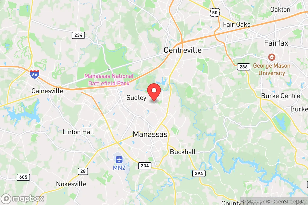
Manassas Park is situated in Prince William County, roughly 30 miles southwest of Washington D.C., placing it within the immediate blast and fallout zone of any major event targeting the federal government. The area’s natural advantages are limited. The terrain is gently rolling Piedmont, offering some concealment but no significant defensible high ground. The Occoquan River and Bull Run provide water sources, but these are heavily trafficked and monitored. The city itself is a small, densely developed enclave (about 2 square miles) surrounded by the larger city of Manassas and suburban sprawl. This density means that in a grid-down scenario, escape routes would be choked quickly—I-66, Route 28, and Route 234 are the primary arteries, and they are notorious for congestion even on a normal Tuesday. The positive is that the area’s historical role as a Civil War crossroads means there are numerous secondary roads and rural cut-throughs, but these require intimate local knowledge to navigate effectively. The climate is moderate, with four distinct seasons, which aids in long-term food storage and water management, but the summer humidity and winter cold snaps demand robust shelter and energy planning.
Risks, exposures, and proximity to fallout-relevant landmarks
The primary risk for Manassas Park is its proximity to Washington D.C., a high-value target for nuclear, EMP, or coordinated conventional attacks. The city lies within the 50-mile radius of the nation’s capital, meaning any ground burst or airburst would likely deposit significant radioactive fallout here, depending on wind patterns. Additionally, the area is ringed by critical infrastructure: Dulles International Airport (15 miles north), Quantico Marine Corps Base (20 miles south), and multiple data centers and government contractor campuses along the Route 28 corridor. These are all potential secondary targets or choke points during unrest. The city itself has no major military installation, but the presence of federal law enforcement and intelligence community personnel in the broader region means that any civil unrest in D.C. would spill over quickly. The 2020 protests and the January 6th events demonstrated that Northern Virginia becomes a staging ground for both government and counter-government movements. For the prepper, this means the area is a high-probability zone for mass casualty events, roadblocks, and resource seizures by federal or state authorities during a declared emergency. The risk of being caught in a “no-go” zone or a mandatory evacuation is substantial.
Practical resilience for a relocator: food, water, energy, and defensibility
For a single individual or family looking to hunker down, Manassas Park presents serious challenges. Water is the most critical vulnerability. The city relies on the Occoquan Reservoir and the Fairfax County Water Authority, a centralized system that would be compromised by an EMP or a coordinated cyberattack. A private well is rare in this dense suburb; most homes are on municipal supply. Preppers must invest in at least a 30-day supply of stored water (1 gallon per person per day) and a high-quality Berkey or similar filter for local surface water, which will be contaminated by runoff and fallout. Food storage is feasible if you have a basement or a dedicated pantry, but the small lot sizes typical of Manassas Park (0.1–0.25 acres) limit gardening and livestock. Community gardens exist but are vulnerable to looting. Energy independence is difficult due to HOA restrictions and the urban setting. Solar panels on a roof are possible but will attract attention. A better bet is a stealth generator setup (e.g., a Honda EU2200i with a propane conversion) and a deep-cycle battery bank, kept out of sight. Defensibility is poor. The city’s grid layout, with cul-de-sacs and narrow streets, makes it easy to seal off but also easy to surround. Neighbors are close, which can be a security asset (mutual aid) or a liability (unprepared families drawing looters). The ideal setup here is a “gray man” approach: blend in, maintain a low profile, and have a pre-planned bug-out route to a rural property in the Shenandoah Valley or West Virginia, which is about a 90-minute drive under normal conditions—but expect that to double or triple during a crisis.
In the final analysis, Manassas Park is a location for the prepper who must remain in the D.C. orbit for work or family obligations but who understands the trade-offs. It is not a survivalist paradise; it is a high-risk, high-convenience zone. The strategic picture demands that you treat this as a temporary staging area, not a long-term retreat. Your resilience plan must prioritize mobility, water storage, and a robust communications setup (ham radio, encrypted messaging) to monitor the situation. The area’s advantages—access to medical care, supply chains, and a large community of potential allies—are real but are contingent on the grid staying up. If the lights go out for more than 72 hours, Manassas Park becomes a dangerous place to be. The wise relocator will use this location as a base to build skills, network with other prepared individuals, and secure a true rural escape route. Anything less is a gamble with your family’s future.
* Values derived from national, state, county, city and local statistics and may differ in a specific area. Last updated: 2026-04-19T10:20:42.000Z
Narrative content on this page is AI-generated and may contain mistakes. Verify any details that matter before acting on them.
ReloMaps may earn a commission from affiliate links at no extra cost to you.