Photo: Wikipedia
Strategic Assessment of Mankato, MN
Workable tactical position. Some exposure to population density or targets, but generally defensible in a crisis.
What does the Strategic Assessment tell us?
Our Strategic Assessment grades tactical survivability of an area. Major population centers, military targets, fallout zones, natural disasters, and border exposure all drive risk — lower exposure means a more defensible position in a crisis.
This is heavily inspired by Joel Skousen's Strategic Relocation book. Highly recommended you checkout the book ($)What does this tell us?
Our Strategic Assessment grades tactical survivability of an area. Major population centers, military targets, fallout zones, natural disasters, and border exposure all drive risk — lower exposure means a more defensible position in a crisis.
This is heavily inspired by Joel Skousen's Strategic Relocation book. Highly recommended you checkout the book ($)Strategic Pillars

Key Distances
Regional Safe Places
Below is our recommended "safe zones" in Minnesota and the surrounding area based on our strategic heuristics. For most people, it's unrealistic to live in a “safe zone” full-time due to work, family or other personal reasons. They tend to be more rural. However, many of these areas are perfect for second homes and retreat properties that double as a vacation home or even a short-term rental.


Important Note: For informational purposes only. This does not mean nothing bad ever happens in the green zones. Please use common sense. This is based on public data and modeled with AI. We tried to take a conservative approach but mistakes happen. We update this regularly as new information becomes available.
Solar Generator Recommendations
Backup power matters more here than in safer locations. We've picked three solar generators across budgets and capacity tiers — start with the budget unit if you only need a few essentials, or step up if you want to run a fridge and HVAC for days at a time.

Jackery Portable Power Station Explorer 300
Budget OptionPower on the Go: Weighing only 11 lbs, it's convenient to set up and store with book-sized foldable solar panels

BLUETTI Portable Power Station AC180
Designed for both indoor and outdoor scenarios, AC180 is highly capable as it has a robost capacity and continuous output power.

EF ECOFLOW DELTA Pro Ultra Power Station
Upgraded PickEcoFlow DELTA Pro Ultra is a whole-home energy system designed to grow with your family. Integrated with the Smart Home Panel 2, it scales to meet your evolving energy needs — keeping your home powered, intelligent, and secure through every stage of life.
We earn a commission, at no additional cost to you.
Strategic Assessment Analysis
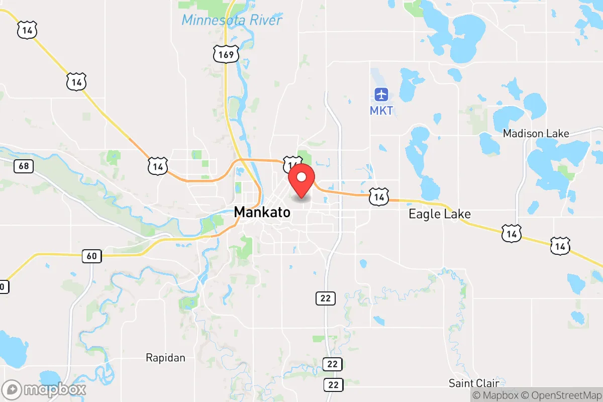
Mankato, Minnesota, offers a surprisingly resilient strategic position for those prioritizing long-term preparedness, sitting roughly 80 miles southwest of the Twin Cities—close enough to monitor urban collapse but far enough to avoid its immediate fallout. The city anchors the Blue Earth River valley, a natural corridor that provides both agricultural abundance and a defensible geography that has historically insulated it from the worst of regional disruptions. For a relocator with a survivalist mindset, Mankato’s combination of distance from primary targets, local food production capacity, and a relatively stable civic infrastructure makes it a credible fallback location in an increasingly uncertain national landscape.
Geographic position and natural advantages for long-term security
Mankato sits at the confluence of the Minnesota and Blue Earth Rivers, a location that historically served as a trading hub and now offers a reliable water source—critical for any extended disruption scenario. The surrounding region is part of the Minnesota River Valley, with bluffs and rolling hills that provide natural terrain breaks, making large-scale movement through the area more chokepoint-dependent than the flat plains to the west. This topography offers modest defensive advantages: elevated positions overlooking the river valleys give residents situational awareness of approaching traffic or threats, while the river itself acts as a natural barrier to the south and east. The city’s position in south-central Minnesota places it roughly 100 miles from the Iowa border, 80 miles from the Twin Cities, and 150 miles from the Sioux Falls metro area—far enough from major population centers to reduce exposure to civil unrest cascades, but close enough to access regional supply chains during normal times. The area sits outside the primary fallout zones of any major military or industrial targets in the Upper Midwest, with the nearest significant strategic infrastructure being the Minneapolis-St. Paul International Airport and the nuclear power plant at Monticello, both over 70 miles away. For a prepper, this geographic buffer is the single most important factor: Mankato is not a primary target in any conventional conflict scenario, and its river valley position makes it a natural rally point for those fleeing urban collapse without being a obvious destination for looters.
Risks, exposures, and proximity to fallout-relevant landmarks
No location is without vulnerabilities, and Mankato has several that a strategic relocator must weigh. The city itself has a population of roughly 45,000, with the broader Mankato-North Mankato metro area approaching 100,000—large enough to create resource competition during a crisis, but small enough that social cohesion remains possible. The primary risk is the city’s position along major transportation corridors: US Highway 169 and State Highway 14 both run through Mankato, connecting it to the Twin Cities and southern Minnesota. During a mass evacuation event, these routes could become clogged with refugees, and the city could face pressure from transient populations seeking resources. The Blue Earth River, while a water asset, also presents flooding risks—the area experienced significant flooding in 1965 and 1993, and any prolonged infrastructure failure could compromise water treatment facilities. More concerning from a survivalist perspective is the proximity of the Mankato Regional Airport, which, while small, could become a target for aerial resupply or military operations in a national emergency. The city also hosts a Minnesota National Guard armory, which could be a focal point for federal or state authority during unrest—potentially drawing unwanted attention. The nearest nuclear power plant, Monticello, is 75 miles north; while not in immediate fallout range, prevailing winds from the northwest could carry contamination toward Mankato in a worst-case scenario. The Prairie Island Indian Community’s nuclear plant, near Red Wing, is roughly 90 miles east-northeast, presenting a similar but lower-probability risk. For a relocator, these exposures are manageable but require planning: a rural homestead 15-20 miles outside the city limits, away from major highways and the river floodplain, would mitigate most of these risks while retaining access to Mankato’s resources.
Practical resilience for a relocator: food, water, energy, and defensibility
Mankato’s practical resilience is where it shines for a prepper. The surrounding region is some of the most productive agricultural land in the United States—Blue Earth County is a top producer of corn, soybeans, and hogs, meaning local food supply chains are robust even during national disruptions. Farmers markets, CSAs, and local grain elevators provide direct access to food outside the industrial grocery system. The city’s water supply comes from the Minnesota River and deep aquifers, with the Mankato Water Treatment Plant capable of processing millions of gallons daily; for a relocator, a well on rural property would provide redundancy. Energy infrastructure is mixed: Mankato is served by Xcel Energy, with a mix of natural gas, coal, and renewable sources, but the grid is vulnerable to the same cascading failures affecting the Upper Midwest. Solar potential is moderate—Minnesota averages 4.5 peak sun hours per day in summer, dropping to 1.5 in winter—so a hybrid system with battery storage and a backup generator is advisable. The area’s defensibility is decent but not fortress-grade: the river valleys and bluffs provide natural chokepoints, but the terrain is not mountainous, and a determined group could approach from multiple directions. The local population skews older and more conservative than the Twin Cities, with a strong Lutheran and Catholic cultural base that values self-reliance and community mutual aid—a positive for building a preparedness network. Gun culture is present but not dominant; Minnesota has relatively permissive firearm laws, with no permit required for purchase and a shall-issue carry permit system. For a relocator, the key is to establish a rural buffer: a property 10-20 miles outside Mankato, with a well, septic, solar panels, and a wood stove, would provide a high degree of independence while keeping the city’s hospitals, hardware stores, and grain elevators within a 30-minute drive.
The overall strategic picture for Mankato is that of a solid B-tier relocation target for the serious prepper. It lacks the extreme isolation of the Montana Rockies or the deep South’s climate advantages, but it offers a realistic balance of resource availability, geographic buffer, and community stability that many more remote locations cannot match. The primary threat is not direct attack but the secondary effects of urban collapse—refugee flows, supply chain breakdowns, and potential civil authority overreach. A relocator who secures a rural property in the surrounding county, builds a local network of like-minded individuals, and maintains a low profile will find Mankato a defensible, sustainable base for weathering the coming instability. The city itself is not a bunker, but it is a viable hub for a distributed preparedness strategy—and in a world where the Twin Cities could become unlivable overnight, that is worth serious consideration.
* Values derived from national, state, county, city and local statistics and may differ in a specific area. Last updated: 2026-04-24T12:27:15.000Z
Narrative content on this page is AI-generated and may contain mistakes. Verify any details that matter before acting on them.
ReloMaps may earn a commission from affiliate links at no extra cost to you.