Photo: Wikipedia
Strategic Assessment of Marble Falls, TX
Meaningful friction. Expect exposure to either population pressure, blast zones, or natural disaster risk. Consider buying a retreat property.
What does the Strategic Assessment tell us?
Our Strategic Assessment grades tactical survivability of an area. Major population centers, military targets, fallout zones, natural disasters, and border exposure all drive risk — lower exposure means a more defensible position in a crisis.
This is heavily inspired by Joel Skousen's Strategic Relocation book. Highly recommended you checkout the book ($)What does this tell us?
Our Strategic Assessment grades tactical survivability of an area. Major population centers, military targets, fallout zones, natural disasters, and border exposure all drive risk — lower exposure means a more defensible position in a crisis.
This is heavily inspired by Joel Skousen's Strategic Relocation book. Highly recommended you checkout the book ($)Strategic Pillars

Key Distances
Regional Safe Places
Below is our recommended "safe zones" in Texas and the surrounding area based on our strategic heuristics. For most people, it's unrealistic to live in a “safe zone” full-time due to work, family or other personal reasons. They tend to be more rural. However, many of these areas are perfect for second homes and retreat properties that double as a vacation home or even a short-term rental.


Important Note: For informational purposes only. This does not mean nothing bad ever happens in the green zones. Please use common sense. This is based on public data and modeled with AI. We tried to take a conservative approach but mistakes happen. We update this regularly as new information becomes available.
Solar Generator Recommendations
Backup power matters more here than in safer locations. We've picked three solar generators across budgets and capacity tiers — start with the budget unit if you only need a few essentials, or step up if you want to run a fridge and HVAC for days at a time.

Jackery Portable Power Station Explorer 300
Budget OptionPower on the Go: Weighing only 11 lbs, it's convenient to set up and store with book-sized foldable solar panels

BLUETTI Portable Power Station AC180
Designed for both indoor and outdoor scenarios, AC180 is highly capable as it has a robost capacity and continuous output power.

EF ECOFLOW DELTA Pro Ultra Power Station
Upgraded PickEcoFlow DELTA Pro Ultra is a whole-home energy system designed to grow with your family. Integrated with the Smart Home Panel 2, it scales to meet your evolving energy needs — keeping your home powered, intelligent, and secure through every stage of life.
We earn a commission, at no additional cost to you.
Strategic Assessment Analysis
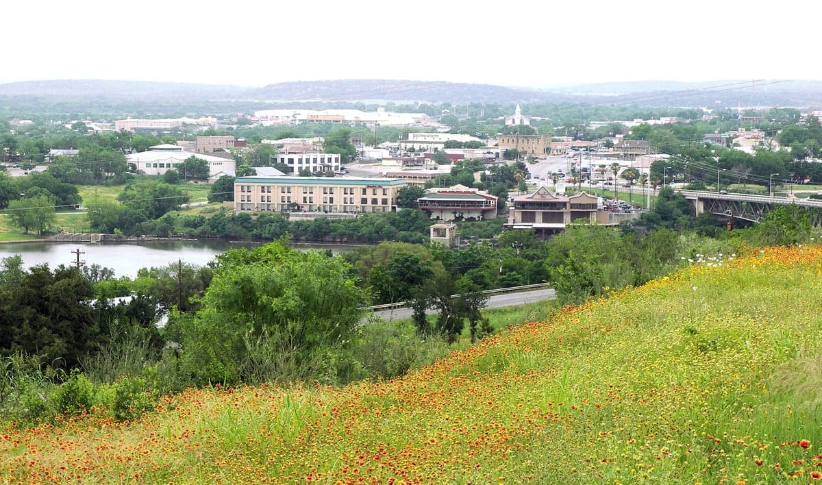
Marble Falls, Texas, sits in a strategic sweet spot that resilience-minded relocators should take seriously: close enough to Austin and San Antonio to access resources, yet far enough to avoid the worst of urban collapse scenarios. Perched on the Colorado River at the edge of the Texas Hill Country, this town of roughly 7,500 offers a blend of natural defensibility, water access, and distance from high-value targets that makes it a viable base for long-term preparedness. For those eyeing a retreat from coastal or metropolitan fragility, Marble Falls presents a credible option—provided you understand both its strengths and its exposures.
Geographic position and natural advantages for long-term security
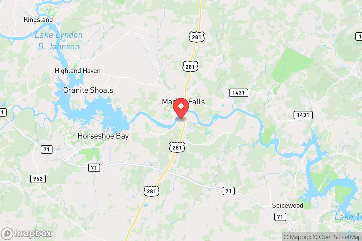
Marble Falls sits in Burnet County, roughly 50 miles northwest of Austin and 90 miles north of San Antonio. That distance is critical: it places the town outside the immediate blast radius or fallout plume of any major metropolitan target, while still being within a day’s drive of medical, supply, and logistical hubs. The surrounding terrain—rolling limestone hills, cedar breaks, and the Colorado River basin—offers natural chokepoints and observation points that make the area more defensible than flat, open country. The Highland Lakes chain, including Lake Marble Falls, Lake LBJ, and Lake Travis to the south, provides a reliable surface water source that many inland Texas towns lack. For a prepper, water access is non-negotiable, and Marble Falls has it in spades. The region’s karst topography also means groundwater is present in many areas, though well depths and yields vary. The climate is semi-arid but not desert; average annual rainfall hovers around 32 inches, enough to support rain catchment systems and small-scale agriculture. The growing season stretches 250+ days, allowing for food production that could supplement stored supplies. Elevation—roughly 800 to 1,000 feet above sea level—offers slight cooling and reduces flood risk compared to coastal or river-bottom areas.
Risks, exposures, and proximity to fallout-relevant landmarks
No location is immune, and Marble Falls has vulnerabilities that a serious relocator must weigh. The most obvious is its proximity to Austin, a major state capital and tech hub that would be a high-priority target in any large-scale conflict or terror event. Fallout patterns depend on wind direction, but prevailing winds in central Texas are from the south and southeast, meaning a strike on Austin could push contamination toward Marble Falls if conditions align. The same logic applies to the nearby nuclear power plant—the South Texas Nuclear Generating Station near Bay City is 150 miles away, but the Comanche Peak plant near Glen Rose is only 80 miles northwest. Neither is an immediate threat under normal conditions, but in a cascading disaster scenario, they represent risk. Additionally, Marble Falls sits along U.S. Highway 281, a major north-south evacuation route from San Antonio to the Hill Country. In a crisis, that road could become a choke point or a target for looters moving out of the cities. The town’s growth has also brought suburban sprawl; new subdivisions are creeping into formerly rural areas, which means more people competing for the same limited resources during a breakdown. Wildfire risk is moderate but real—the Hill Country’s juniper and oak brush can fuel fast-moving fires, especially during drought years. Flooding along the Colorado River and its tributaries is another seasonal concern, though the Highland Lakes system provides some flood control.
Practical resilience for a relocator: food, water, energy, and defensibility
For someone serious about self-sufficiency, Marble Falls offers a workable foundation. Water is the strongest asset: the Colorado River and Highland Lakes provide a year-round surface supply, and many properties in the county have access to groundwater via wells. Rainwater catchment is legal and practical, with average roof space on a typical Hill Country home yielding 500–1,000 gallons per inch of rain. The local climate supports vegetable gardens, fruit trees (peach, fig, persimmon), and even some grains, though soil quality varies and may require amendment. Livestock—chickens, goats, cattle—are common in the surrounding county, and local feed stores and co-ops supply essentials. Energy resilience is mixed. The area is served by the Pedernales Electric Cooperative, which has a decent reliability record, but the grid in central Texas is part of ERCOT and has shown fragility during winter storms (see February 2021). Solar potential is excellent—the region averages over 260 sunny days per year—and off-grid solar setups are feasible, though local permitting and HOA restrictions can be obstacles. Defensibility is moderate: the terrain offers natural cover and elevated positions, but the town itself is not easily sealed off. The best strategy is to choose a property on a dead-end road or in a rural subdivision with limited access points. Burnet County has a strong gun culture and a sheriff’s office that is generally supportive of Second Amendment rights, which aligns with a preparedness mindset. The local population skews conservative and self-reliant, which can be an asset in forming mutual-aid networks. However, the influx of Austin refugees in recent years has diluted that homogeneity, so vetting neighbors is wise.
The overall strategic picture for Marble Falls is cautiously positive for the resilience-minded relocator. It offers a rare combination of water access, defensible terrain, and distance from primary targets, all within a region that still values independence and preparedness. The downsides—proximity to Austin, growth pressure, and grid fragility—are manageable with proper planning. For a single individual or a family looking to build a long-term base that can weather both slow-burn societal decline and acute crises, Marble Falls deserves a serious look. Just don’t expect it to stay quiet forever; the Hill Country is being discovered, and the window for affordable, well-positioned land is closing. If you’re serious, move sooner rather than later.
* Values derived from national, state, county, city and local statistics and may differ in a specific area. Last updated: 2026-04-26T19:47:23.000Z
Narrative content on this page is AI-generated and may contain mistakes. Verify any details that matter before acting on them.
ReloMaps may earn a commission from affiliate links at no extra cost to you.