
Photo: Wikipedia
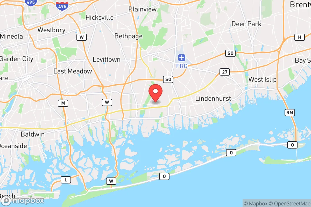
Strategic Assessment of Massapequa Park, NY
High tactical risk. This location is likely close to major population centers, strategic targets, or sits in a high-disaster corridor. A retreat property and careful exit planning is required.
What does the Strategic Assessment tell us?
Our Strategic Assessment grades tactical survivability of an area. Major population centers, military targets, fallout zones, natural disasters, and border exposure all drive risk — lower exposure means a more defensible position in a crisis.
This is heavily inspired by Joel Skousen's Strategic Relocation book. Highly recommended you checkout the book ($)What does this tell us?
Our Strategic Assessment grades tactical survivability of an area. Major population centers, military targets, fallout zones, natural disasters, and border exposure all drive risk — lower exposure means a more defensible position in a crisis.
This is heavily inspired by Joel Skousen's Strategic Relocation book. Highly recommended you checkout the book ($)Strategic Pillars

Key Distances
Regional Safe Places
Below is our recommended "safe zones" in New York and the surrounding area based on our strategic heuristics. For most people, it's unrealistic to live in a “safe zone” full-time due to work, family or other personal reasons. They tend to be more rural. However, many of these areas are perfect for second homes and retreat properties that double as a vacation home or even a short-term rental.


Important Note: For informational purposes only. This does not mean nothing bad ever happens in the green zones. Please use common sense. This is based on public data and modeled with AI. We tried to take a conservative approach but mistakes happen. We update this regularly as new information becomes available.
Solar Generator Recommendations
Backup power matters more here than in safer locations. We've picked three solar generators across budgets and capacity tiers — start with the budget unit if you only need a few essentials, or step up if you want to run a fridge and HVAC for days at a time.

Jackery Portable Power Station Explorer 300
Budget OptionPower on the Go: Weighing only 11 lbs, it's convenient to set up and store with book-sized foldable solar panels

BLUETTI Portable Power Station AC180
Designed for both indoor and outdoor scenarios, AC180 is highly capable as it has a robost capacity and continuous output power.

EF ECOFLOW DELTA Pro Ultra Power Station
Upgraded PickEcoFlow DELTA Pro Ultra is a whole-home energy system designed to grow with your family. Integrated with the Smart Home Panel 2, it scales to meet your evolving energy needs — keeping your home powered, intelligent, and secure through every stage of life.
We earn a commission, at no additional cost to you.
Strategic Assessment Analysis
Massapequa Park, New York, presents a complex strategic picture for the conservative-leaning prepper or survivalist. Its primary advantage—proximity to New York City’s economic engine—is also its most glaring vulnerability in a crisis scenario. While the village offers a dense suburban fabric with some natural buffers, its location on the South Shore of Long Island places it squarely within the shadow of major metropolitan risks, including potential civil unrest, mass casualty events, and fallout from a variety of disaster scenarios. For a relocator prioritizing long-term resilience over convenience, this area demands a sober, clear-eyed assessment of trade-offs.
Geographic position and natural advantages for a survivalist
Massapequa Park sits on the South Shore of Long Island, roughly 35 miles east of Manhattan, within the Town of Oyster Bay. Its geography is defined by the South Shore’s barrier islands and the Great South Bay, which provides a natural water barrier to the south. The area is part of the larger Massapequa region, which includes Massapequa and Massapequa Park proper. The village itself is a compact, residential community of about 17,000 people, with a mix of single-family homes and some multi-family units. The proximity to the Atlantic Ocean and the Great South Bay offers a potential source of seafood and water-based escape routes, but this is a double-edged sword. The flat, low-lying terrain—much of it built on former marshland—means the area is highly vulnerable to storm surge and flooding, as demonstrated by Hurricane Sandy in 2012. For a prepper, the natural advantages are limited: the ocean provides a food source, but the lack of high ground, dense forests, or defensible terrain makes it a poor choice for a bug-out location. The area’s primary natural buffer is the bay itself, which could slow movement from the south but also traps residents against the water if escape is needed.
Risks, exposures, and proximity to fallout-relevant landmarks
The most significant strategic liability for Massapequa Park is its location within the New York metropolitan area’s blast and fallout radius. The village lies approximately 25 miles from the Indian Point Energy Center (now decommissioned but still housing spent fuel) in Buchanan, NY, and about 30 miles from the Millstone Nuclear Power Station in Waterford, Connecticut. In a nuclear event—whether from an accident, terrorist attack, or state-level conflict—the prevailing winds across Long Island typically blow from the west and northwest, meaning fallout from a Manhattan or upstate detonation could sweep directly over the South Shore. Additionally, Massapequa Park is within 10 miles of the Long Island MacArthur Airport in Ronkonkoma, a potential target for air-based attacks or military staging. The area is also crisscrossed by major transportation arteries: the Southern State Parkway, Sunrise Highway, and the Long Island Rail Road’s Babylon Branch. These corridors, while convenient for daily life, become choke points and targets during civil unrest or mass evacuation events. The proximity to New York City (35 miles) means any large-scale civil disturbance—riots, supply chain collapses, or mass casualty events—will ripple outward quickly, and Massapequa Park’s suburban density (over 4,000 people per square mile) means there is little room to maneuver or maintain operational security. The village’s location on a narrow island also creates a single-point-of-failure risk: all road and rail egress funnels through a handful of bridges and tunnels, which could be compromised in a crisis.
Practical resilience for a relocator: food, water, energy, and defensibility
For a relocator assessing daily survival logistics, Massapequa Park offers a mixed bag. Food security is moderate: the area has several supermarkets (Stop & Shop, King Kullen, and a local Key Food), but these are typical suburban stores with just-in-time supply chains. In a prolonged disruption, shelves would empty within 48 hours. The Great South Bay provides fishing and crabbing opportunities, but these require knowledge, gear, and access to a boat or kayak—and the bay’s water quality is compromised by runoff and sewage overflows after heavy rains. Water security is a major concern: the village relies on the Nassau County water system, which draws from the Magothy aquifer. In a fallout or contamination event, this groundwater could be compromised, and the municipal system lacks redundancy. A prepper would need to stockpile at least two weeks of water per person or invest in a high-quality filtration system (e.g., Berkey or reverse osmosis) and know how to access local surface water, which is brackish and requires desalination. Energy resilience is poor: the grid is above-ground and vulnerable to storms and sabotage. Solar panels are viable but require battery storage, and the village’s zoning codes may restrict visible installations. Natural gas is available for heating, but pipelines are a single point of failure. Defensibility is the weakest link. The village’s grid-like street layout, with small lots and close neighbors, offers no natural chokepoints or cover. A determined group could easily move through the area, and the high population density means any conflict would involve many non-combatants. The best defensive strategy here is low-profile integration: blending in as a normal resident, maintaining a well-stocked basement or garage, and having a pre-planned bug-out route to less populated areas upstate (e.g., the Catskills or Adirondacks). The Massapequa Park train station, while convenient for commuting, is a liability—it’s a known gathering point that could be targeted or overwhelmed.
In the final strategic picture, Massapequa Park is a location of convenience, not resilience. It works for a relocator who needs to maintain a professional career in the New York area while building a low-key preparedness posture, but it fails as a long-term survival destination. The combination of high population density, flat terrain, coastal flood risk, and proximity to major targets makes it a high-risk area for anyone concerned with civil unrest, mass casualty events, or nuclear fallout. For a conservative-leaning individual or family prioritizing self-sufficiency and security, the trade-offs are stark: you gain access to a robust local economy and infrastructure, but you sacrifice defensibility, escape routes, and buffer from metropolitan chaos. The best use of this location is as a temporary staging point—a place to build resources, network with like-minded locals (there are several active gun clubs and outdoor groups in Nassau County), and prepare for a move to a more defensible rural property. If you are committed to staying, invest heavily in underground storage, a reliable vehicle with a full tank always ready, and a detailed evacuation plan that accounts for the area’s limited egress. Otherwise, consider this a strategic warning: Massapequa Park is a nice place to live, but a dangerous place to be when things go wrong.
* Values derived from national, state, county, city and local statistics and may differ in a specific area. Last updated: 2026-04-23T02:48:44.000Z
Narrative content on this page is AI-generated and may contain mistakes. Verify any details that matter before acting on them.
ReloMaps may earn a commission from affiliate links at no extra cost to you.