Photo: Backroad Packers via Unsplash
Strategic Assessment of Mccall, ID
Strong survivability profile. Good buffer from population centers, with manageable environmental and tactical risks.
What does the Strategic Assessment tell us?
Our Strategic Assessment grades tactical survivability of an area. Major population centers, military targets, fallout zones, natural disasters, and border exposure all drive risk — lower exposure means a more defensible position in a crisis.
This is heavily inspired by Joel Skousen's Strategic Relocation book. Highly recommended you checkout the book ($)What does this tell us?
Our Strategic Assessment grades tactical survivability of an area. Major population centers, military targets, fallout zones, natural disasters, and border exposure all drive risk — lower exposure means a more defensible position in a crisis.
This is heavily inspired by Joel Skousen's Strategic Relocation book. Highly recommended you checkout the book ($)Strategic Pillars

Key Distances
Regional Safe Places
Below is our recommended "safe zones" in Idaho and the surrounding area based on our strategic heuristics. For most people, it's unrealistic to live in a “safe zone” full-time due to work, family or other personal reasons. They tend to be more rural. However, many of these areas are perfect for second homes and retreat properties that double as a vacation home or even a short-term rental.


Important Note: For informational purposes only. This does not mean nothing bad ever happens in the green zones. Please use common sense. This is based on public data and modeled with AI. We tried to take a conservative approach but mistakes happen. We update this regularly as new information becomes available.
Solar Generator Recommendations
Backup power matters more here than in safer locations. We've picked three solar generators across budgets and capacity tiers — start with the budget unit if you only need a few essentials, or step up if you want to run a fridge and HVAC for days at a time.

Jackery Portable Power Station Explorer 300
Budget OptionPower on the Go: Weighing only 11 lbs, it's convenient to set up and store with book-sized foldable solar panels

BLUETTI Portable Power Station AC180
Designed for both indoor and outdoor scenarios, AC180 is highly capable as it has a robost capacity and continuous output power.

EF ECOFLOW DELTA Pro Ultra Power Station
Upgraded PickEcoFlow DELTA Pro Ultra is a whole-home energy system designed to grow with your family. Integrated with the Smart Home Panel 2, it scales to meet your evolving energy needs — keeping your home powered, intelligent, and secure through every stage of life.
We earn a commission, at no additional cost to you.
Strategic Assessment Analysis
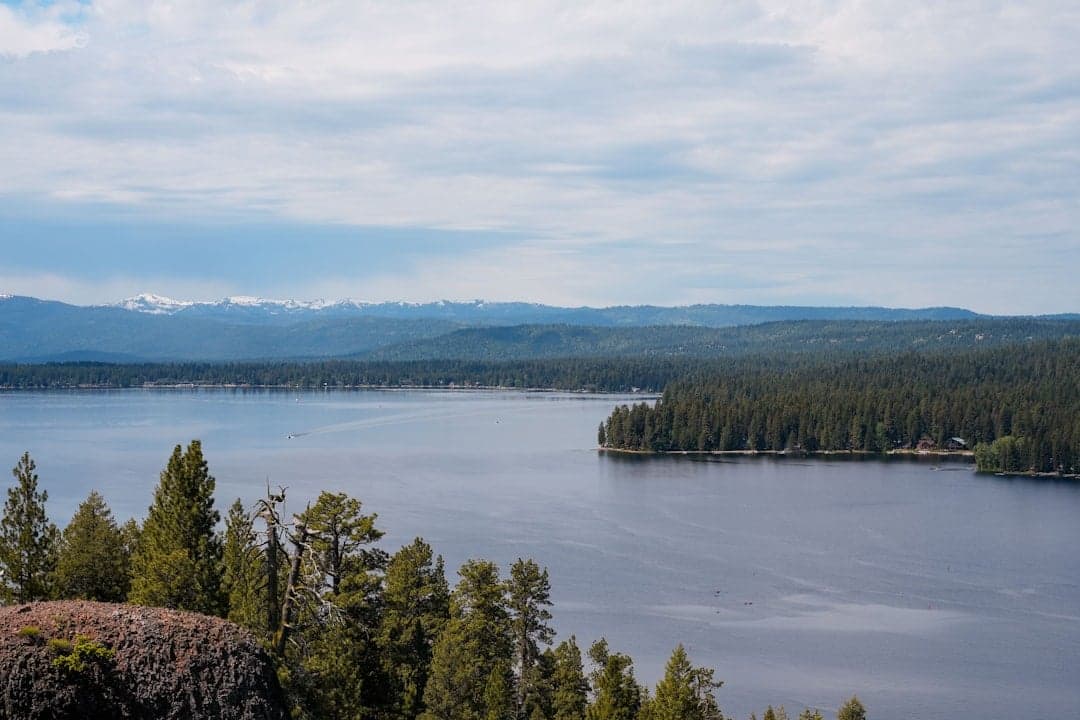
McCall, Idaho, offers a compelling strategic position for those prioritizing resilience and long-term security, largely due to its remote mountain setting and limited exposure to major metropolitan vulnerabilities. Nestled in the Payette National Forest at the southern edge of the Salmon River Mountains, this town of roughly 3,500 year-round residents sits about 100 miles north of Boise—close enough for supply runs but far enough to avoid the immediate fallout zones of a major population center. The area’s natural isolation, combined with a conservative-leaning local culture and a growing network of self-sufficient homesteaders, makes it a serious contender for anyone evaluating relocation through a prepper or survivalist lens. However, the same geography that provides buffers also introduces distinct challenges, from winter access constraints to proximity to certain infrastructure targets, which require careful consideration.
Geographic position and natural advantages for long-term security
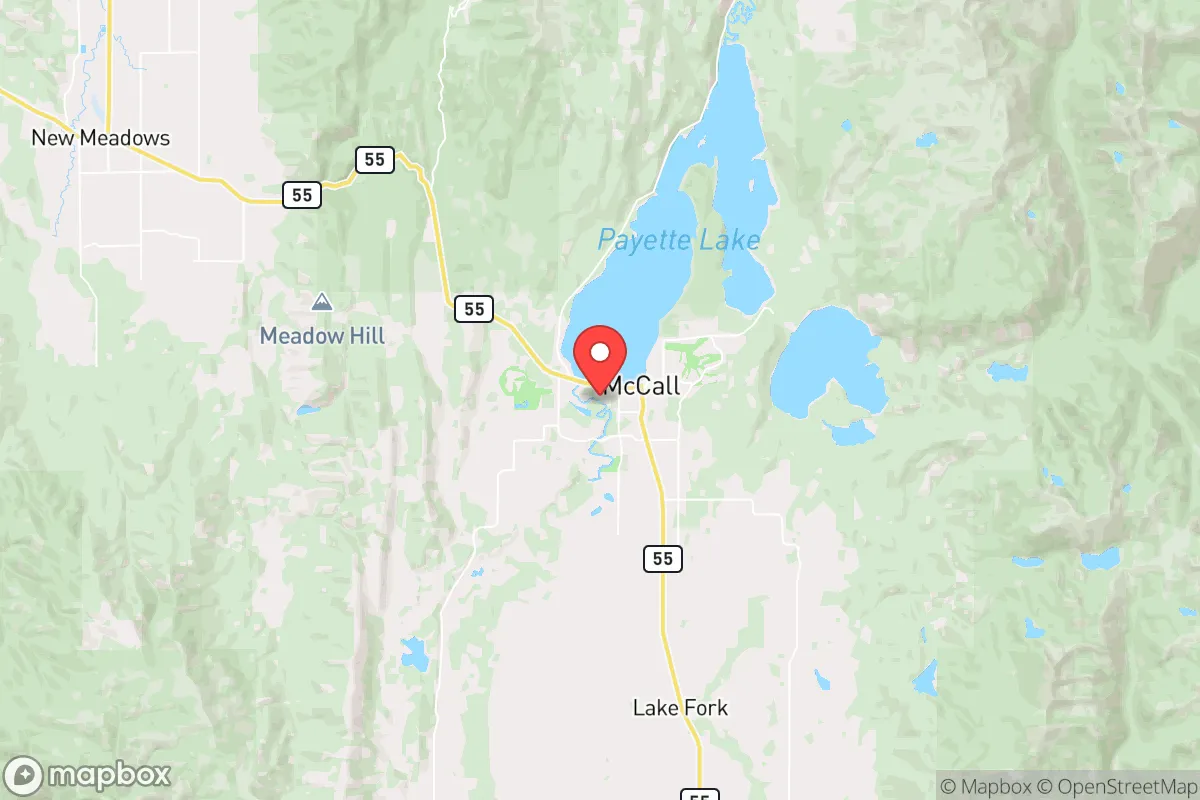
McCall’s primary strategic asset is its location within a high-altitude basin surrounded by the Payette National Forest and the Frank Church-River of No Return Wilderness, one of the largest contiguous roadless areas in the lower 48. This terrain creates a natural defensive perimeter: the only paved routes in and out are Idaho State Highway 55 from the south and a handful of secondary roads that are often impassable in winter. For a relocator, this means any large-scale movement of people or resources toward the area would be funneled through a single choke point, which can be monitored or controlled. The town itself sits at 5,000 feet elevation, with the surrounding peaks rising to 9,000 feet, offering excellent vantage points and limited line-of-sight exposure from lower valleys. The local economy is anchored by tourism—skiing at Brundage Mountain and lake recreation on Payette Lake—but this also means a seasonal population surge that could strain resources during a crisis. Still, the year-round community is tight-knit, with a strong culture of hunting, fishing, and wood heating that aligns with self-reliance principles. The area’s low population density (roughly 10 people per square mile in Valley County) further reduces the risk of disease spread or resource competition during a breakdown scenario.
Risks, exposures, and proximity to fallout-relevant landmarks
While McCall’s isolation is a strength, it is not immune to threats. The most significant risk is its proximity to Boise, which at 100 miles is within the blast and fallout radius of a nuclear detonation targeting the state capital or its associated military and government infrastructure. Boise is home to the Idaho National Guard’s Gowen Field, the Boise Airport (a potential military staging point), and the state capitol—all plausible targets in a major conflict. Prevailing winds from the southwest could carry fallout directly into the McCall area, though the mountain terrain would provide some shielding. Additionally, the town is near the Brundage Mountain ski resort, which could become a target for symbolic attacks or a gathering point for displaced populations. On the infrastructure side, McCall’s power comes from Idaho Power’s grid, which relies on hydroelectric dams along the Payette River—dams that could be compromised by sabotage or natural disaster. The town’s water supply is drawn from Payette Lake and local wells, but treatment facilities are centralized and vulnerable to disruption. For a relocator, the key takeaway is that McCall is not a zero-risk location; it is a moderate-risk zone that requires active preparation for both natural and man-made events. The area’s history of wildfires (e.g., the 2021 Boundary Fire) and heavy snow loads also means structural resilience—like metal roofs, defensible space, and backup heat—is non-negotiable.
Practical resilience for a relocator: food, water, energy, and defensibility
For someone serious about self-sufficiency, McCall offers a mixed but workable foundation. Food security is achievable through a combination of local agriculture, hunting, and storage. The growing season is short (roughly 90 frost-free days), but cold-hardy crops like potatoes, carrots, and kale do well, and the surrounding forests are rich in elk, deer, and grouse. The Payette Lake and nearby rivers provide trout and salmon, though fishing pressure increases in summer. Local farmers’ markets and co-ops exist, but supply chains are thin—most groceries come from Boise, so stockpiling non-perishables is essential. Water is abundant: Payette Lake holds over 1.5 million acre-feet, and many properties have private wells. However, winter freezing can disrupt surface water access, so a hand pump or gravity-fed system is wise. Energy resilience is a weak point: the grid is reliable in normal times but vulnerable to ice storms and wildfire-related outages. Solar potential is moderate (about 4.5 peak sun hours per day in summer, dropping to 1.5 in winter), so a hybrid system with propane or wood backup is recommended. Defensibility is strong due to the terrain—most homes are on hillsides or in valleys with limited approach routes. The local sheriff’s office is small (about 12 deputies for the entire county), so community watch and personal security measures are the norm. Firearms ownership is high, and there is a strong culture of mutual aid among neighbors, which is a significant social asset in a crisis.
Overall, McCall presents a balanced strategic picture for the conservative relocator who values isolation, natural resources, and a like-minded community, but who is willing to invest in infrastructure and accept certain geographic risks. It is not a bunker—it is a working mountain town where preparedness is a lifestyle, not a hobby. The proximity to Boise is a double-edged sword: it provides access to medical care and supplies in normal times, but it also introduces a vulnerability that requires a plan for evacuation or shelter-in-place during a major event. For those who can secure a property with well water, wood heat, and defensible space, and who are comfortable with a six-month winter, McCall offers one of the better risk-reward ratios in the Intermountain West. The key is to treat it as a base of operations, not a final fortress—and to build relationships with the local prepper network before the crisis hits.
* Values derived from national, state, county, city and local statistics and may differ in a specific area. Last updated: 2026-04-21T10:56:16.000Z
Narrative content on this page is AI-generated and may contain mistakes. Verify any details that matter before acting on them.
ReloMaps may earn a commission from affiliate links at no extra cost to you.