
Photo: Evan McNamara via Unsplash
Strategic Assessment of Methuen Town, MA
Meaningful friction. Expect exposure to either population pressure, blast zones, or natural disaster risk. Consider buying a retreat property.
What does the Strategic Assessment tell us?
Our Strategic Assessment grades tactical survivability of an area. Major population centers, military targets, fallout zones, natural disasters, and border exposure all drive risk — lower exposure means a more defensible position in a crisis.
This is heavily inspired by Joel Skousen's Strategic Relocation book. Highly recommended you checkout the book ($)What does this tell us?
Our Strategic Assessment grades tactical survivability of an area. Major population centers, military targets, fallout zones, natural disasters, and border exposure all drive risk — lower exposure means a more defensible position in a crisis.
This is heavily inspired by Joel Skousen's Strategic Relocation book. Highly recommended you checkout the book ($)Strategic Pillars

Key Distances
Regional Safe Places
Below is our recommended "safe zones" in Massachusetts and the surrounding area based on our strategic heuristics. For most people, it's unrealistic to live in a “safe zone” full-time due to work, family or other personal reasons. They tend to be more rural. However, many of these areas are perfect for second homes and retreat properties that double as a vacation home or even a short-term rental.


Important Note: For informational purposes only. This does not mean nothing bad ever happens in the green zones. Please use common sense. This is based on public data and modeled with AI. We tried to take a conservative approach but mistakes happen. We update this regularly as new information becomes available.
Solar Generator Recommendations
Backup power matters more here than in safer locations. We've picked three solar generators across budgets and capacity tiers — start with the budget unit if you only need a few essentials, or step up if you want to run a fridge and HVAC for days at a time.

Jackery Portable Power Station Explorer 300
Budget OptionPower on the Go: Weighing only 11 lbs, it's convenient to set up and store with book-sized foldable solar panels

BLUETTI Portable Power Station AC180
Designed for both indoor and outdoor scenarios, AC180 is highly capable as it has a robost capacity and continuous output power.

EF ECOFLOW DELTA Pro Ultra Power Station
Upgraded PickEcoFlow DELTA Pro Ultra is a whole-home energy system designed to grow with your family. Integrated with the Smart Home Panel 2, it scales to meet your evolving energy needs — keeping your home powered, intelligent, and secure through every stage of life.
We earn a commission, at no additional cost to you.
Strategic Assessment Analysis
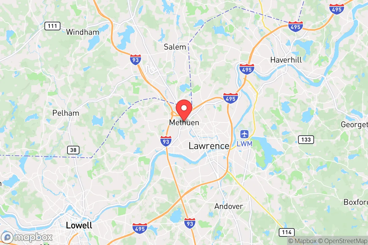
Methuen Town, Massachusetts, sits in a precarious strategic position that demands serious consideration from anyone prioritizing long-term resilience. Located roughly 30 miles north of Boston and straddling the New Hampshire border, this Merrimack Valley community of roughly 50,000 offers a mixed bag for the prepper-minded relocator: proximity to critical infrastructure and escape routes, but also exposure to the cascading risks that come with being within the blast radius of a major metropolitan target. For a conservative-leaning individual or family weighing the trade-offs between access and security, Methuen presents a location that requires careful, sober assessment rather than blind optimism.
Geographic position and natural advantages for long-term survival
Methuen’s primary strategic asset is its location along the Interstate 93 corridor, which provides a direct north-south evacuation route away from Boston and toward the sparsely populated forests of northern New England. The town sits at the junction of I-93 and I-495, offering multiple egress options in the event of a regional emergency. The Merrimack River runs through the southern portion of the town, providing a potential water source, though its industrial history means treatment would be essential. The area’s rolling hills and mixed hardwood forests offer some natural cover and defensible terrain, particularly in the northern and western sections where development thins out. The proximity to the New Hampshire border is a notable advantage: in a scenario where Massachusetts state-level governance becomes unreliable or hostile to conservative values, a short drive north places a relocator under a different state jurisdiction with lower taxes, fewer restrictions, and a more firearm-friendly legal environment. The average elevation of about 150 feet above sea level provides minimal flood risk from the river, though low-lying areas near the banks remain vulnerable during heavy rain events.
Risks, exposures, and proximity to fallout-relevant landmarks
The most glaring vulnerability for Methuen is its proximity to Boston, a Tier 1 target for any major geopolitical conflict or terrorist attack. At just 30 miles from downtown, a nuclear detonation or large-scale conventional strike on the city would place Methuen well within the dangerous fallout zone, depending on wind patterns. The town is also within 15 miles of Hanscom Air Force Base in Bedford, a key military installation that could become a secondary target. The Lawrence Municipal Airport, located just south of Methuen, is a general aviation facility that could see increased military or emergency traffic during a crisis, drawing unwanted attention. Industrial risks include the Methuen Rail Yard and multiple chemical storage facilities along the Merrimack River, which could become secondary hazards during a disaster. The town’s population density—roughly 2,200 people per square mile—is moderate for the region but high enough that civil unrest or supply chain disruptions could lead to rapid resource depletion. The I-93 and I-495 interchange is a notorious chokepoint; during an evacuation, this area would become gridlocked within hours, trapping residents who rely on personal vehicles. Methuen’s diverse demographic makeup—with a significant immigrant population and a strong Democratic voting record—may create cultural friction for conservative relocators seeking like-minded community, though this is more a social consideration than a survival one.
Practical resilience for a relocator: food, water, energy, and defensibility
For a family or individual serious about self-sufficiency, Methuen offers a mixed picture. Municipal water comes from the Merrimack River and is treated at the Methuen Water Treatment Plant, which is vulnerable to both contamination and power loss. A backup well or rainwater catchment system is strongly advised, as the town’s water infrastructure is aging and could fail during a prolonged emergency. The local soil is a mix of sandy loam and clay, suitable for small-scale gardening but not ideal for large-scale food production without significant amendment. The growing season runs roughly from May to October, limiting year-round food independence. For energy, Methuen is served by National Grid for electricity and gas, both of which are vulnerable to storm-related outages—the region averages one to two major power outages per year, typically from nor’easters or hurricanes. Solar panels with battery storage are a viable option, though the area’s average of 200 sunny days per year is below the national average. Defensibility is a concern: most residential neighborhoods are suburban sprawl with open sightlines and limited natural barriers. The northern and western edges of town, near the New Hampshire border, offer more rural properties with wooded lots and longer driveways, which are preferable for security. Methuen has a police force of about 80 officers and a fire department with three stations, but in a widespread crisis, response times would stretch thin. The town’s gun laws are governed by Massachusetts, which has some of the strictest firearm regulations in the country—including licensing requirements, assault weapon bans, and magazine capacity limits—making it difficult to stockpile defensive tools legally. For food storage, the town has several supermarkets (Market Basket, Shaw’s, Stop & Shop) but no major wholesale clubs within city limits; the nearest Costco is in Salem, New Hampshire, about 10 miles north, which is a better option for bulk purchasing.
Overall, Methuen Town occupies a strategic middle ground that may appeal to relocators who want Boston access for work or family but are willing to accept elevated risk for that convenience. The town’s greatest strength is its position as a gateway to New Hampshire, offering a quick escape to a more conservative, less regulated environment. Its greatest weakness is its proximity to a high-value target zone and the associated fallout, gridlock, and resource competition. For a single individual or family with a prepper mindset, Methuen is best viewed as a temporary staging area or a location to be abandoned within the first 24-48 hours of a major event, rather than a long-term survival retreat. If you are committed to the area, prioritize a property in the far northern or western sections, invest in off-grid water and power systems, and maintain a vehicle with a full tank and a pre-packed bug-out bag at all times. The strategic calculus here is clear: Methuen offers convenience and access, but at a cost that may be too high for those who prioritize security above all else.
* Values derived from national, state, county, city and local statistics and may differ in a specific area. Last updated: 2026-04-23T05:06:20.000Z
Narrative content on this page is AI-generated and may contain mistakes. Verify any details that matter before acting on them.
ReloMaps may earn a commission from affiliate links at no extra cost to you.