Photo: Wikipedia
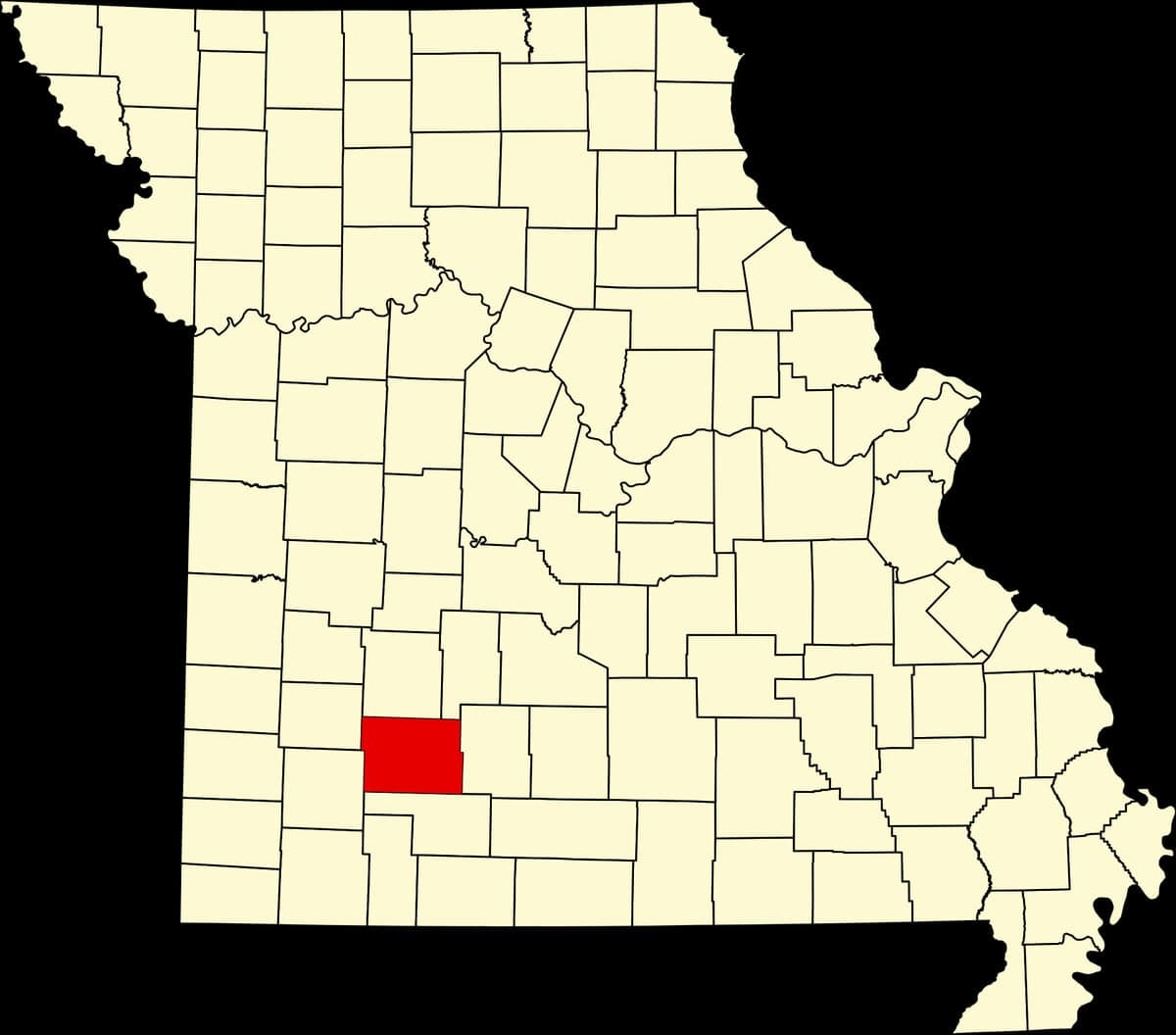
Strategic Assessment of Greene County
Workable tactical position. Some exposure to population density or targets, but generally defensible in a crisis.
What does the Strategic Assessment tell us?
Our Strategic Assessment grades tactical survivability of an area. Major population centers, military targets, fallout zones, natural disasters, and border exposure all drive risk — lower exposure means a more defensible position in a crisis.
This is heavily inspired by Joel Skousen's Strategic Relocation book. Highly recommended you checkout the book ($)What does this tell us?
Our Strategic Assessment grades tactical survivability of an area. Major population centers, military targets, fallout zones, natural disasters, and border exposure all drive risk — lower exposure means a more defensible position in a crisis.
This is heavily inspired by Joel Skousen's Strategic Relocation book. Highly recommended you checkout the book ($)Strategic Pillars

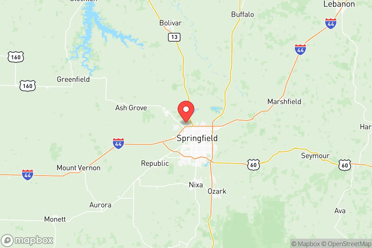
Key Distances
Strategic Assessment Analysis
Greene County, Missouri, anchored by Springfield, offers a compelling mix of Midwestern stability and strategic depth for those prioritizing resilience and self-sufficiency. Its location in the Ozarks, roughly equidistant from the major population centers of Kansas City, St. Louis, and Tulsa, provides a buffer from the immediate fallout of a major metropolitan crisis while still granting access to regional infrastructure. The area’s economic base—healthcare, logistics, and manufacturing—is diversified enough to weather downturns, and its topography and climate present fewer catastrophic natural threats than coastal or tornado-alley extremes. For a relocator thinking seriously about disaster readiness, Greene County presents a solid, if not perfect, foundation.
Geographic position and natural advantages for long-term stability
Greene County sits in the heart of the Ozark Plateau, a region defined by rolling hills, limestone bluffs, and abundant freshwater springs. This topography offers natural defensibility: the hills and hollows create visual and physical barriers that slow movement and provide numerous choke points, a factor that matters if you’re thinking about security in a grid-down scenario. The county is drained by the James River and its tributaries, including the Finley River and Wilson’s Creek, which feed into Table Rock Lake and Lake Springfield—both reliable surface water sources. The area’s karst geology means groundwater is plentiful but also vulnerable to contamination from surface runoff, so well placement and filtration are non-negotiable. The climate is humid continental, with hot summers and cold winters, but it lacks the hurricane storm surge, wildfire risk, or seismic activity that plague other regions. The growing season is about 190 days, long enough for serious gardening and small-scale agriculture, and the soil in the river valleys is decent for row crops. The Ozarks are also far from the nation’s major nuclear power plants (the nearest is Callaway Plant, about 150 miles east) and the strategic target corridors of the coasts, reducing the risk of direct fallout from a high-yield strike.
Risks, exposures, and proximity to fallout-relevant landmarks
No place is immune to risk, and Greene County has its share. The most immediate man-made threat is Whiteman Air Force Base, located about 60 miles northeast in Johnson County, Missouri. Whiteman is home to the B-2 Spirit stealth bomber fleet—a high-value strategic target in any major conflict. A strike on Whiteman would produce significant fallout that could drift into Greene County depending on wind patterns, especially if the attack is a ground burst. The county is also within 200 miles of the Fort Leonard Wood military installation, a major training and engineering center, and the Springfield-Branson National Airport itself hosts the 148th Fighter Wing of the Missouri Air National Guard, flying F-15s. While not a primary target, any military airfield becomes a secondary target in a prolonged conflict. On the natural disaster front, the region sits in the heart of Tornado Alley. The 2011 Joplin tornado, just 70 miles west, is a stark reminder that EF-4 and EF-5 events are possible. The county’s hilly terrain can also produce flash flooding in low-lying areas like the James River floodplain near Ozark and Nixa. There are no major refineries or chemical plants within the county, but the I-44 corridor carries hazardous materials through Springfield daily, and a derailment or truck accident near the city center could cause localized contamination. The biggest risk, however, is the county’s own growth: Springfield’s population has steadily increased, and suburban sprawl into Republic and Willard is reducing the rural buffer that once made the area feel remote.
Practical resilience for a relocator: food, water, energy, and defensibility
For someone serious about self-sufficiency, Greene County offers a strong baseline. Water is the easiest win: the Ozarks are one of the most water-rich regions in the central U.S. The Ozark Aquifer provides deep groundwater, and dozens of perennial springs—like the ones feeding Wilson’s Creek—offer surface water that can be filtered or boiled. A well-drilled to 200-400 feet in the county’s rural areas will typically yield 10-20 gallons per minute. Food production is viable but not effortless. The growing season is long enough for tomatoes, peppers, squash, and greens, and the region has a strong tradition of small-scale livestock—chickens, goats, and cattle are common. The Springfield Farmers Market is one of the largest in the state, and local food networks are robust, but a relocator should plan to supplement with stored staples. The county has several grain elevators and feed stores, but a major disruption would strain supply chains quickly. Energy is a mixed bag. Springfield is served by City Utilities, which operates a coal-fired plant and a natural gas plant, plus a growing solar portfolio. The grid is reasonably stable, but rural areas on cooperative power (like Ash Grove and Fair Grove) are more prone to outages from ice storms or wind. Solar is viable—the region gets about 200 sunny days per year—but winter cloud cover can be persistent. Wood heat is a practical backup: the Ozarks have abundant hardwood forests, and firewood is cheap or free if you’re willing to cut it. Defensibility is where Greene County shines. The rural areas outside the Springfield metro—especially the hilly terrain around Battlefield and Strafford—offer good line-of-sight control and natural barriers. The county’s network of county roads and state highways (like MO-125 and MO-13) provides multiple egress routes, though I-44 and US-65 can become choke points during an evacuation. The local culture is heavily armed and self-reliant; gun ownership is common, and the sheriff’s department is generally supportive of Second Amendment rights. That said, the county’s population density in Springfield itself (about 170,000 people) means that a city-dwelling relocator would need to be well outside the urban core to achieve true defensibility.
The overall strategic picture for Greene County is one of moderate resilience with clear trade-offs. Its geographic isolation from coastal targets and major industrial corridors is a genuine advantage, and the abundance of water and arable land makes long-term survival feasible. The proximity to Whiteman AFB and Fort Leonard Wood is the single largest vulnerability—a direct hit on either would make the county a fallout zone for days. But for a relocator who is willing to invest in a well, solar panels, and a solid pantry, and who chooses a rural property in the hills south or west of Springfield, Greene County offers a realistic balance of access to modern amenities and the space to ride out a crisis. It is not a bug-out paradise, but it is a place where a prepared family can build a sustainable life without feeling like they’ve moved to the edge of the earth.
* Values derived from national, state, county, city and local statistics and may differ in a specific area. Last updated: 2026-06-12T17:40:25.000Z
Narrative content on this page is AI-generated and may contain mistakes. Verify any details that matter before acting on them.
ReloMaps may earn a commission from affiliate links at no extra cost to you.