
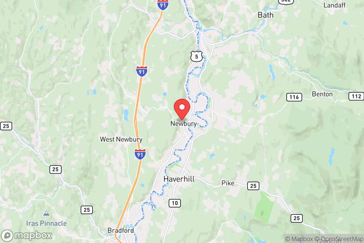
Strategic Assessment of Newbury, VT
Workable tactical position. Some exposure to population density or targets, but generally defensible in a crisis.
What does the Strategic Assessment tell us?
Our Strategic Assessment grades tactical survivability of an area. Major population centers, military targets, fallout zones, natural disasters, and border exposure all drive risk — lower exposure means a more defensible position in a crisis.
This is heavily inspired by Joel Skousen's Strategic Relocation book. Highly recommended you checkout the book ($)What does this tell us?
Our Strategic Assessment grades tactical survivability of an area. Major population centers, military targets, fallout zones, natural disasters, and border exposure all drive risk — lower exposure means a more defensible position in a crisis.
This is heavily inspired by Joel Skousen's Strategic Relocation book. Highly recommended you checkout the book ($)Strategic Pillars

Key Distances
Regional Safe Places
Below is our recommended "safe zones" in Vermont and the surrounding area based on our strategic heuristics. For most people, it's unrealistic to live in a “safe zone” full-time due to work, family or other personal reasons. They tend to be more rural. However, many of these areas are perfect for second homes and retreat properties that double as a vacation home or even a short-term rental.


Important Note: For informational purposes only. This does not mean nothing bad ever happens in the green zones. Please use common sense. This is based on public data and modeled with AI. We tried to take a conservative approach but mistakes happen. We update this regularly as new information becomes available.
Solar Generator Recommendations
Backup power matters more here than in safer locations. We've picked three solar generators across budgets and capacity tiers — start with the budget unit if you only need a few essentials, or step up if you want to run a fridge and HVAC for days at a time.

Jackery Portable Power Station Explorer 300
Budget OptionPower on the Go: Weighing only 11 lbs, it's convenient to set up and store with book-sized foldable solar panels

BLUETTI Portable Power Station AC180
Designed for both indoor and outdoor scenarios, AC180 is highly capable as it has a robost capacity and continuous output power.

EF ECOFLOW DELTA Pro Ultra Power Station
Upgraded PickEcoFlow DELTA Pro Ultra is a whole-home energy system designed to grow with your family. Integrated with the Smart Home Panel 2, it scales to meet your evolving energy needs — keeping your home powered, intelligent, and secure through every stage of life.
We earn a commission, at no additional cost to you.
Strategic Assessment Analysis
Newbury, Vermont, offers a compelling strategic position for those prioritizing resilience and self-sufficiency, sitting in the Connecticut River Valley with a population under 2,000 and a low-density, rural character that inherently reduces exposure to cascading failures from larger population centers. Its location along the Vermont-New Hampshire border places it roughly 30 miles from the state capital of Montpelier and about 60 miles from the Burlington metro area, distances that provide meaningful buffer from urban unrest while still allowing access to regional resources. The town’s topography, straddling the river and rising into the hills of the Vermont Piedmont, creates natural defensibility and multiple escape corridors, a key advantage for anyone thinking through worst-case scenarios. For a conservative-leaning relocator concerned with national instability, Newbury represents a quiet, off-the-radar option that doesn’t scream “prepper destination” but quietly checks many practical boxes.
Geographic position and natural advantages for long-term security
Newbury’s geography is its strongest asset for strategic relocation. The town sits on the western bank of the Connecticut River, which provides a reliable water source and a natural boundary that complicates approach from the east. To the west, the land rises into the Orange County hills, with elevations around 1,200 to 1,500 feet offering good vantage points and limited line-of-sight from main roads. The area is part of the broader White Mountain National Forest region, with extensive public lands to the north and east in New Hampshire that can serve as buffer zones or fallback areas. The Connecticut River itself is navigable by small craft for miles, offering a potential transportation route if roads become compromised. Winters are cold and snowy, averaging 80-100 inches annually, which is a double-edged sword: it discourages transient populations and provides natural insulation, but demands serious preparation for heating, food storage, and mobility. The growing season is short, roughly 120 days, limiting subsistence farming without greenhouse infrastructure, but the fertile river-bottom soils support reliable hay and vegetable production for those who plan ahead.
Risks, exposures, and proximity to fallout-relevant landmarks
No location is without risk, and Newbury has specific vulnerabilities that a strategic relocator must weigh. The most significant is the Vermont Yankee Nuclear Power Plant, located just 10 miles south in Vernon, which is currently in decommissioning but still stores spent nuclear fuel on-site. A catastrophic event at that facility—whether from accident, sabotage, or natural disaster—could render large swaths of the Connecticut River Valley uninhabitable for years. The prevailing winds generally blow south-southwest, which somewhat mitigates direct fallout risk for Newbury, but a major release would still pose a serious threat depending on weather patterns. Additionally, Interstate 91 runs through the town, providing quick access from population centers like White River Junction (15 miles south) and St. Johnsbury (20 miles north). This highway is a double-edged sword: it’s useful for supply runs in normal times, but in a crisis it becomes a funnel for refugees, looters, or government convoys. The town is also within 60 miles of the Lebanon, NH regional airport and the Dartmouth-Hitchcock Medical Center, which are likely to be overwhelmed or targeted in a major event. For those concerned with electromagnetic pulse (EMP) threats, the rural electrical grid here is less hardened than urban systems, but the low population density means fewer cascading failures from grid collapse.
Practical resilience for a relocator: food, water, energy, and defensibility
For a relocator serious about self-sufficiency, Newbury offers a workable baseline with significant room for improvement. Water is abundant: the Connecticut River is year-round, and the town has numerous streams and groundwater wells. Most properties with acreage have access to private wells, and the water table is generally high in the valley. Surface water requires filtration and boiling, but the volume is there. Food production is limited by the short growing season, but the river valley’s microclimate is slightly warmer than surrounding hills, allowing for cold-hardy crops like potatoes, kale, and root vegetables. Local agriculture is small-scale, with a few farms selling hay, beef, and maple syrup—none of which will sustain a family without your own land and planning. The nearest grocery stores are in Wells River (3 miles) and Woodsville, NH (5 miles), both small and vulnerable to supply chain disruptions. For energy, wood heat is the most practical off-grid option, with abundant hardwood forests on the hillsides. Solar is viable but requires battery storage and winter snow management; average daily sunlight in December is around 3.5 hours, so panels alone won’t cut it for winter heating. Defensibility is moderate: the river and hills provide natural chokepoints, but the town is spread out along the I-91 corridor, making it hard to secure a perimeter. A well-chosen property set back from the main road, with a clear view of approaches and a backup route into the hills, would be ideal. The local population is predominantly older, rural, and self-reliant—the kind of community that tends to band together rather than fragment in a crisis, which is a significant intangible advantage.
The overall strategic picture for Newbury is one of cautious optimism for the prepared relocator. It offers genuine natural buffers, a reliable water source, and a low-profile existence that avoids the attention that comes with more famous prepper destinations like Montana or Idaho. The trade-offs are real: the nuclear plant to the south, the highway corridor, and the harsh winters demand serious planning and investment in infrastructure. For a single individual or family willing to put in the work—stockpiling food, installing wood heat, learning basic medical skills, and building community relationships—Newbury provides a defensible, sustainable base that is close enough to regional resources to be practical but far enough to avoid the worst of urban collapse. It is not a bug-out location; it is a live-in location that requires daily maintenance and foresight. For those who view current national trends with concern and want a place where preparation actually matters, Newbury is worth a hard look.
* Values derived from national, state, county, city and local statistics and may differ in a specific area. Last updated: 2026-04-30T06:46:32.000Z
Narrative content on this page is AI-generated and may contain mistakes. Verify any details that matter before acting on them.
ReloMaps may earn a commission from affiliate links at no extra cost to you.