
Photo: Wikipedia
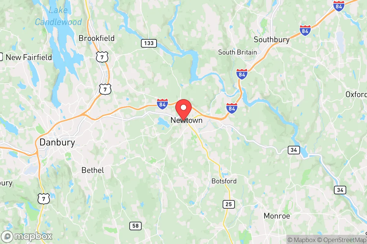
Strategic Assessment of Newtown, CT
Multiple tactical vulnerabilities. Population density, target proximity, or disaster risk are likely compounding. A retreat property and exit planning is required.
What does the Strategic Assessment tell us?
Our Strategic Assessment grades tactical survivability of an area. Major population centers, military targets, fallout zones, natural disasters, and border exposure all drive risk — lower exposure means a more defensible position in a crisis.
This is heavily inspired by Joel Skousen's Strategic Relocation book. Highly recommended you checkout the book ($)What does this tell us?
Our Strategic Assessment grades tactical survivability of an area. Major population centers, military targets, fallout zones, natural disasters, and border exposure all drive risk — lower exposure means a more defensible position in a crisis.
This is heavily inspired by Joel Skousen's Strategic Relocation book. Highly recommended you checkout the book ($)Strategic Pillars

Key Distances
Regional Safe Places
Below is our recommended "safe zones" in Connecticut and the surrounding area based on our strategic heuristics. For most people, it's unrealistic to live in a “safe zone” full-time due to work, family or other personal reasons. They tend to be more rural. However, many of these areas are perfect for second homes and retreat properties that double as a vacation home or even a short-term rental.


Important Note: For informational purposes only. This does not mean nothing bad ever happens in the green zones. Please use common sense. This is based on public data and modeled with AI. We tried to take a conservative approach but mistakes happen. We update this regularly as new information becomes available.
Solar Generator Recommendations
Backup power matters more here than in safer locations. We've picked three solar generators across budgets and capacity tiers — start with the budget unit if you only need a few essentials, or step up if you want to run a fridge and HVAC for days at a time.

Jackery Portable Power Station Explorer 300
Budget OptionPower on the Go: Weighing only 11 lbs, it's convenient to set up and store with book-sized foldable solar panels

BLUETTI Portable Power Station AC180
Designed for both indoor and outdoor scenarios, AC180 is highly capable as it has a robost capacity and continuous output power.

EF ECOFLOW DELTA Pro Ultra Power Station
Upgraded PickEcoFlow DELTA Pro Ultra is a whole-home energy system designed to grow with your family. Integrated with the Smart Home Panel 2, it scales to meet your evolving energy needs — keeping your home powered, intelligent, and secure through every stage of life.
We earn a commission, at no additional cost to you.
Strategic Assessment Analysis
Newtown, Connecticut, sits in a strategic sweet spot that few relocation analysts fully appreciate: close enough to major economic corridors to sustain a professional career, yet far enough into the Litchfield Hills to offer genuine geographic buffer from the worst-case scenarios that preppers and survivalists are tracking. The town’s resilience profile is anchored by its position in western Fairfield County, roughly 60 miles from Manhattan and 40 miles from Hartford, but separated from those population centers by the Housatonic River valley and a network of state forests that create natural chokepoints. For a relocator thinking about civic unrest, supply chain collapse, or mass casualty events, Newtown offers a rare combination of rural defensibility and access to the infrastructure that keeps a household running when the grid gets shaky.
Geographic position and natural advantages for long-term security
Newtown’s terrain is the first thing a strategic relocator should note. The town sits on a series of rolling hills with elevations reaching over 500 feet in places, providing natural vantage points and drainage advantages that flatter coastal areas lack. The surrounding landscape is dominated by the Paugussett State Forest and the sprawling 4,000-acre Lake Lillinonah watershed, which together create a buffer of undeveloped land between Newtown and the more densely settled corridors of Danbury and Bridgeport. This isn’t flat farmland where any approaching threat can be seen from miles away—it’s broken, wooded terrain that slows movement and provides cover. For a family or individual concerned with defensible position and retreat options, the topography alone makes Newtown stand out among Connecticut towns of similar size.
The water situation is equally important. Lake Lillinonah, the Housatonic River, and numerous smaller ponds and streams give the area a hydrological resilience that many inland towns lack. The town’s water supply is drawn primarily from the Pootatuck Aquifer and several reservoir systems, meaning a household with a well or access to surface water is not dependent on municipal treatment plants that could become single points of failure during a prolonged grid-down event. The presence of the Housatonic also means that even in a severe drought, there is a major water source within a few miles of most residential properties. For a prepper thinking about water independence and long-term sustainability, Newtown’s natural hydrology is a significant asset.
Risks, exposures, and proximity to fallout-relevant landmarks
No strategic assessment is honest without addressing the downsides, and Newtown has several that a relocator must weigh carefully. The most obvious is proximity to New York City and the I-95 corridor. While 60 miles provides a meaningful buffer, it is not a safe distance from the fallout effects of a major event in the metro area—whether that event is a nuclear detonation, a large-scale terrorist attack, or a cascading infrastructure failure that sends millions of people fleeing outward. Newtown lies directly along the primary evacuation routes from New York into western Connecticut, specifically Route 7 and I-84, which means that in a mass evacuation scenario, the town could face significant pressure from transient populations moving through. The town’s own population of roughly 28,000 could be overwhelmed by a sudden influx of refugees from the coast, and local law enforcement resources would be stretched thin.
There are also specific infrastructure targets within a concerning radius. The Indian Point nuclear plant in Buchanan, New York, is roughly 40 miles southwest of Newtown. While the plant is in the process of decommissioning, the spent fuel storage on site remains a radiological hazard that could be targeted or could fail in a cascading disaster. Additionally, the town is within 50 miles of several major transportation hubs, including Stewart International Airport and the Port of New York and New Jersey, both of which are plausible targets for state-actor attacks or large-scale accidents. For a relocator with a conservative worldview who views federal infrastructure as both a target and a liability, Newtown’s position within the outer ring of these risk zones is a factor that demands mitigation planning, not dismissal.
Practical resilience for a relocator: food, water, energy, and defensibility
On the practical side, Newtown offers a mix of advantages and gaps that a serious prepper needs to address before moving. The local food system is better than most of Connecticut: there are multiple working farms within the town limits, including the well-known Blue Jay Orchards and the Newtown Farmers Market, which operate year-round and provide direct access to locally grown produce, meat, and dairy. The town also has several feed stores and agricultural supply outlets that stock seeds, tools, and animal feed, which is critical for anyone planning to establish a home garden or small livestock operation. The soil quality in the region is generally good for gardening, with loamy topsoil in the valleys and adequate drainage on the hillsides.
Energy resilience is a mixed picture. The town’s electric grid is served by Eversource, and power outages are common during winter storms and nor’easters—sometimes lasting several days. This is actually a positive for a prepper, because it means the local population is accustomed to outages and the infrastructure for backup power is well-established. Solar panel installations are common, and there are multiple local contractors who specialize in off-grid battery systems and generator integration. Propane delivery is reliable, and wood stoves are a standard feature in many older homes. For a relocator planning to harden a property, Newtown’s building stock is generally older and built to higher standards than suburban sprawl, with many homes having basements, stone foundations, and well water already in place.
Defensibility at the property level is strong. The town’s zoning is predominantly large-lot residential, with minimum lot sizes of one to two acres in most areas and significant stretches of conservation land that create natural buffers between neighbors. This spacing reduces the risk of fire spreading between structures and makes it harder for any hostile group to move through the area undetected. The road network is a mix of winding two-lane roads and dead-end streets, which can be easily monitored and, in a worst-case scenario, blocked or defended. For a relocator thinking about operational security and the ability to control access to a property, Newtown’s layout is far more favorable than a typical suburban subdivision.
The overall strategic picture for a conservative relocator
Newtown is not a bug-out location for someone who wants to disappear into the deep wilderness—it is a working town with schools, a police department, and a functioning local economy. For a conservative relocator who wants to maintain a professional career while building a resilient household, it offers a realistic middle ground. The town’s political culture is moderate, with a mix of longtime residents and commuters, but the local government is generally competent and the community has a strong sense of civic identity that would likely hold together under stress. The biggest strategic weakness is the proximity to New York and the evacuation routes that run through the area, but that risk can be managed with proper planning—stockpiling supplies, establishing a secondary retreat further north, and building relationships with neighbors who share a similar mindset. For a single individual or family looking to balance access to opportunity with genuine preparedness, Newtown is one of the better options in the Northeast, provided you go in with eyes open and a plan for the vulnerabilities that come with being in the outer ring of a major metropolitan area.
* Values derived from national, state, county, city and local statistics and may differ in a specific area. Last updated: 2026-04-19T07:38:50.000Z
Narrative content on this page is AI-generated and may contain mistakes. Verify any details that matter before acting on them.
ReloMaps may earn a commission from affiliate links at no extra cost to you.