Photo: Wikipedia
Strategic Assessment of North Charleston, SC
Multiple tactical vulnerabilities. Population density, target proximity, or disaster risk are likely compounding. A retreat property and exit planning is required.
What does the Strategic Assessment tell us?
Our Strategic Assessment grades tactical survivability of an area. Major population centers, military targets, fallout zones, natural disasters, and border exposure all drive risk — lower exposure means a more defensible position in a crisis.
This is heavily inspired by Joel Skousen's Strategic Relocation book. Highly recommended you checkout the book ($)What does this tell us?
Our Strategic Assessment grades tactical survivability of an area. Major population centers, military targets, fallout zones, natural disasters, and border exposure all drive risk — lower exposure means a more defensible position in a crisis.
This is heavily inspired by Joel Skousen's Strategic Relocation book. Highly recommended you checkout the book ($)Strategic Pillars

Key Distances
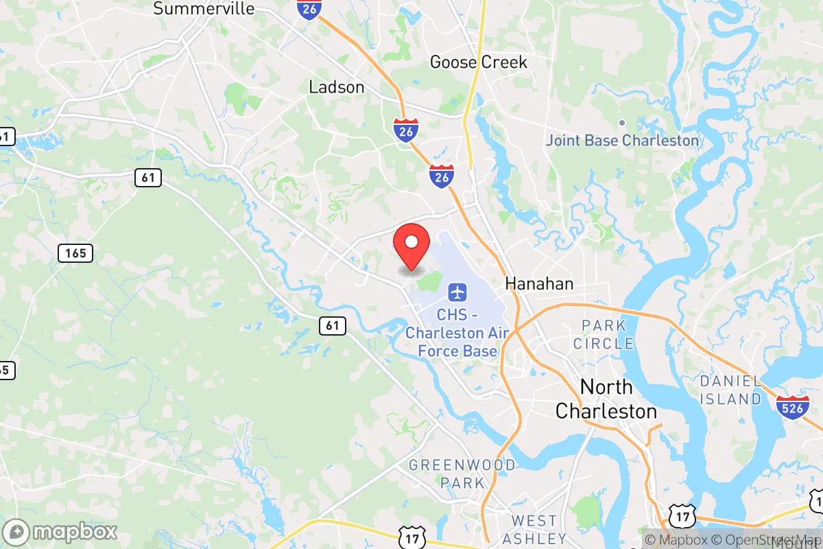
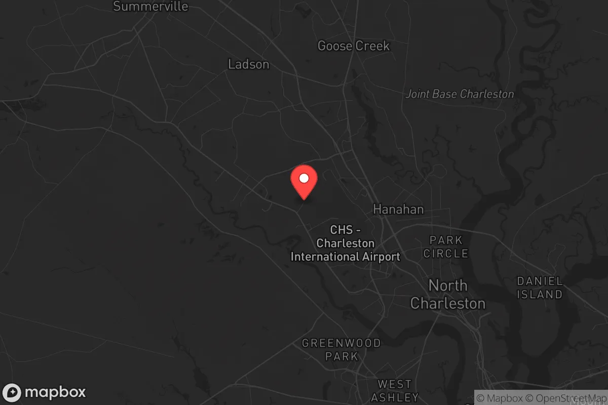
Regional Safe Places
Below is our recommended "safe zones" in South Carolina and the surrounding area based on our strategic heuristics. For most people, it's unrealistic to live in a “safe zone” full-time due to work, family or other personal reasons. They tend to be more rural. However, many of these areas are perfect for second homes and retreat properties that double as a vacation home or even a short-term rental.


Important Note: For informational purposes only. This does not mean nothing bad ever happens in the green zones. Please use common sense. This is based on public data and modeled with AI. We tried to take a conservative approach but mistakes happen. We update this regularly as new information becomes available.
Solar Generator Recommendations
Backup power matters more here than in safer locations. We've picked three solar generators across budgets and capacity tiers — start with the budget unit if you only need a few essentials, or step up if you want to run a fridge and HVAC for days at a time.

Jackery Portable Power Station Explorer 300
Budget OptionPower on the Go: Weighing only 11 lbs, it's convenient to set up and store with book-sized foldable solar panels

BLUETTI Portable Power Station AC180
Designed for both indoor and outdoor scenarios, AC180 is highly capable as it has a robost capacity and continuous output power.

EF ECOFLOW DELTA Pro Ultra Power Station
Upgraded PickEcoFlow DELTA Pro Ultra is a whole-home energy system designed to grow with your family. Integrated with the Smart Home Panel 2, it scales to meet your evolving energy needs — keeping your home powered, intelligent, and secure through every stage of life.
We earn a commission, at no additional cost to you.
Strategic Assessment Analysis
North Charleston, South Carolina, sits in a precarious strategic position that demands serious consideration for anyone prioritizing long-term resilience. While its location offers undeniable logistical advantages, the city’s proximity to major military and industrial targets, combined with its dense urban fabric, creates a risk profile that many preppers and conservative-minded relocators should weigh carefully. This assessment examines the area’s geographic strengths, its exposure to fallout-relevant threats, and the practical realities of sustaining yourself here when the grid falters.
Geographic position and natural advantages for long-term stability
North Charleston’s location at the confluence of the Cooper and Ashley Rivers, just inland from the Atlantic coast, provides a rare blend of maritime access and inland buffer. The city sits roughly 10 miles from the open ocean, offering a strategic retreat from direct storm surge while still benefiting from the Charleston Harbor’s shipping infrastructure. The surrounding Lowcountry terrain is flat and marshy, which limits large-scale agricultural potential but provides natural water abundance—the area averages about 48 inches of rainfall annually, with the Cooper River and numerous creeks offering reliable freshwater sources. The climate is humid subtropical, with mild winters that rarely see freezing temperatures, meaning year-round gardening is feasible with proper planning. For a relocator focused on self-sufficiency, the long growing season (roughly 250 frost-free days) is a genuine asset, allowing for multiple crop cycles and the ability to maintain food production even during colder months. The region’s elevation is uniformly low—most of North Charleston sits below 20 feet above sea level—which is a double-edged sword: it simplifies water access but makes the area vulnerable to flooding from heavy rains or storm surge. The surrounding landscape includes the Francis Marion National Forest about 30 miles north, offering a potential bug-out location with dense pine and hardwood cover, though it’s not without its own risks (wildfire, limited water in drought).
Risks, exposures, and proximity to fallout-relevant landmarks
The most glaring vulnerability for North Charleston is its proximity to Joint Base Charleston, a major military installation that includes the Charleston Air Force Base and Naval Weapons Station. This base is a primary hub for C-17 transport aircraft and houses the 628th Air Base Wing, making it a high-priority target in any conflict scenario. The base’s location is roughly 5 miles from downtown North Charleston, meaning a conventional or nuclear strike on the installation would likely devastate large portions of the city. Beyond military targets, the Port of Charleston—one of the busiest container ports on the East Coast—sits just east of the city, handling billions in trade annually. In a scenario of economic collapse or supply chain disruption, the port becomes a focal point for civil unrest, looting, and potential federal intervention. The city’s industrial corridor along the Cooper River includes chemical storage facilities, fuel depots, and manufacturing plants that could become secondary hazards in a disaster. For a prepper, the density of the Charleston metropolitan area (roughly 800,000 people in the metro) means that any major event—hurricane, earthquake, or civil unrest—will trigger mass evacuation along a limited road network. Interstate 26 is the primary evacuation route west, and it bottlenecks quickly; during Hurricane Hugo in 1989, gridlock trapped thousands. The area also sits in a seismically active zone—the 1886 Charleston earthquake (estimated magnitude 7.3) remains a historical precedent for a catastrophic event that could level unreinforced masonry buildings and disrupt utilities for weeks.
Practical resilience for a relocator: food, water, energy, and defensibility
For someone serious about self-reliance, North Charleston presents a mixed bag. Water is abundant but requires treatment—the Cooper River is brackish in parts, and shallow wells in the Lowcountry often yield water with high iron and sulfur content. A deep well (200+ feet) is advisable but costly, and the local water table means septic systems can fail in heavy rains. Rainwater catchment is viable given the annual rainfall, but storage tanks must account for hurricane contamination. Food production is feasible with raised beds or hydroponics, but the sandy, acidic soil requires amendment; local extension services recommend adding organic matter and lime. The growing season supports warm-weather crops (tomatoes, peppers, okra, sweet potatoes) from April through October, with cool-season greens possible in winter with frost protection. For energy, solar is viable—the area averages about 5 peak sun hours per day—but grid-tied systems are vulnerable to storm damage, and battery storage is essential for nighttime and cloudy periods. Natural gas is available in most of the city, but a pipeline disruption would cut supply. Defensibility is the weakest point: North Charleston is a sprawling, low-density city with numerous entry points, limited natural chokepoints, and a high crime rate (violent crime is roughly 2.5 times the national average). The city’s layout—a mix of suburban neighborhoods, industrial zones, and commercial strips—makes it difficult to secure a perimeter. Rural properties in Berkeley or Dorchester counties offer better defensibility, but they come with longer commutes and reduced access to supplies. For a single individual or family, a well-fortified home on the city’s northern edge (near the Summerville line) provides a compromise: proximity to resources with a slightly lower population density.
The overall strategic picture for North Charleston is one of calculated risk. The area’s natural advantages—water, climate, and coastal access—are real, but they are overshadowed by the concentration of high-value targets and the inherent instability of a major port city. For a prepper with a conservative worldview, the calculus is clear: North Charleston offers a base for logistical operations and supply caching, but it is not a long-term survival redoubt. The smart play is to treat it as a staging area—secure a property with a well, solar, and food storage, but maintain a bug-out plan for the Francis Marion National Forest or the rural Upstate. The city’s resilience depends on the stability of the national grid and supply chain; if those fail, North Charleston becomes a liability rather than an asset. For those willing to accept the risks and invest in hardening a property, it can work, but it demands constant vigilance and a realistic understanding of the threats. In short: North Charleston is a place to live prepared, not a place to hide.
* Values derived from national, state, county, city and local statistics and may differ in a specific area. Last updated: 2026-04-29T23:25:22.000Z
Narrative content on this page is AI-generated and may contain mistakes. Verify any details that matter before acting on them.
ReloMaps may earn a commission from affiliate links at no extra cost to you.