
Photo: Wikipedia
Strategic Assessment of Oakdale, MN
Multiple tactical vulnerabilities. Population density, target proximity, or disaster risk are likely compounding. A retreat property and exit planning is required.
What does the Strategic Assessment tell us?
Our Strategic Assessment grades tactical survivability of an area. Major population centers, military targets, fallout zones, natural disasters, and border exposure all drive risk — lower exposure means a more defensible position in a crisis.
This is heavily inspired by Joel Skousen's Strategic Relocation book. Highly recommended you checkout the book ($)What does this tell us?
Our Strategic Assessment grades tactical survivability of an area. Major population centers, military targets, fallout zones, natural disasters, and border exposure all drive risk — lower exposure means a more defensible position in a crisis.
This is heavily inspired by Joel Skousen's Strategic Relocation book. Highly recommended you checkout the book ($)Strategic Pillars

Key Distances
Regional Safe Places
Below is our recommended "safe zones" in Minnesota and the surrounding area based on our strategic heuristics. For most people, it's unrealistic to live in a “safe zone” full-time due to work, family or other personal reasons. They tend to be more rural. However, many of these areas are perfect for second homes and retreat properties that double as a vacation home or even a short-term rental.


Important Note: For informational purposes only. This does not mean nothing bad ever happens in the green zones. Please use common sense. This is based on public data and modeled with AI. We tried to take a conservative approach but mistakes happen. We update this regularly as new information becomes available.
Solar Generator Recommendations
Backup power matters more here than in safer locations. We've picked three solar generators across budgets and capacity tiers — start with the budget unit if you only need a few essentials, or step up if you want to run a fridge and HVAC for days at a time.

Jackery Portable Power Station Explorer 300
Budget OptionPower on the Go: Weighing only 11 lbs, it's convenient to set up and store with book-sized foldable solar panels

BLUETTI Portable Power Station AC180
Designed for both indoor and outdoor scenarios, AC180 is highly capable as it has a robost capacity and continuous output power.

EF ECOFLOW DELTA Pro Ultra Power Station
Upgraded PickEcoFlow DELTA Pro Ultra is a whole-home energy system designed to grow with your family. Integrated with the Smart Home Panel 2, it scales to meet your evolving energy needs — keeping your home powered, intelligent, and secure through every stage of life.
We earn a commission, at no additional cost to you.
Strategic Assessment Analysis
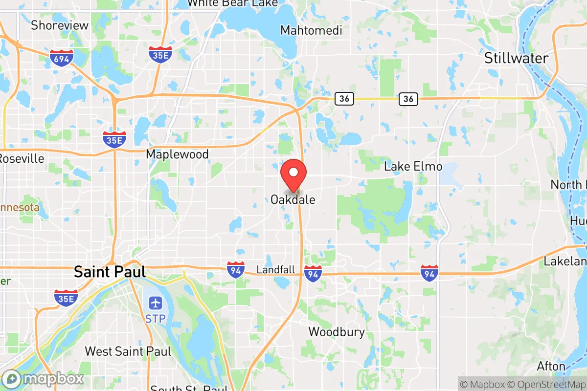
Oakdale, Minnesota, sits in a precarious but potentially viable position for the strategic relocator. While its location within the eastern Twin Cities metro offers access to regional resources, it also places you squarely within a high-risk zone for civil unrest, supply chain disruption, and proximity to major fallout targets. The key to understanding Oakdale’s resilience lies in its specific geography—close enough to leverage metro infrastructure, yet with enough local buffer and natural features to offer a defensible foothold if you plan ahead. This isn’t a remote bug-out location; it’s a suburban staging ground that requires deliberate hardening and a clear-eyed assessment of the threats that come with being near a major population center.
Geographic position and natural advantages for long-term survival
Oakdale’s position in Washington County gives it a few underappreciated natural advantages. The city sits along the southern edge of the St. Croix River Valley, a major water source and natural barrier that could slow movement from the east during a crisis. The Tamarack Nature Preserve and surrounding wetlands provide a green buffer that limits dense development and offers some cover for those who know the terrain. The area’s rolling hills and hardwood forests are not dramatic, but they break up sightlines and create microclimates that can support small-scale food production and water catchment. The Mississippi River is roughly 10 miles west, and the St. Croix River is about 5 miles east, giving you two major water arteries for transport or emergency supply routes—if they remain uncontested. The bedrock geology here is primarily sedimentary, with some shallow aquifers, meaning well water is possible but requires careful siting and testing. For the prepper, the key takeaway is that Oakdale is not a flat, exposed prairie town; it has enough topographic variety to offer concealment and defensible positions, especially in the neighborhoods near the river bluffs.
Risks, exposures, and proximity to fallout-relevant landmarks
This is where the analysis gets sobering. Oakdale’s greatest vulnerability is its proximity to Minneapolis-St. Paul International Airport (MSP), roughly 15 miles southwest. In a major conflict or terrorist event, MSP is a high-value target for airburst or ground-level detonation. The prevailing winds from the southwest would carry fallout directly over Oakdale within hours. The 3M headquarters in Maplewood (just west) and the Xcel Energy plants along the Mississippi are additional industrial targets that could release toxic plumes or become secondary hazards. The I-694/I-94 corridor runs through the city, making it a chokepoint for evacuation or military movement. During civil unrest, this highway becomes a liability—it’s a natural funnel for looters, refugees, or government convoys. The Washington County Jail and Oakdale’s own police station are local landmarks that could become targets if law and order break down. The St. Paul Downtown Airport and Lockheed Martin’s facility in Eagan are also within 20 miles, adding to the target density. For the strategic relocator, the calculus is clear: Oakdale is within the blast and fallout radius of multiple high-value targets. You need a plan for shelter-in-place with at least two weeks of sealed supplies, a reliable air filtration system, and a route out that avoids the major highways.
Practical resilience for a relocator: food, water, energy, and defensibility
On the practical side, Oakdale offers a mixed bag. Water is the most critical resource, and the city’s municipal supply comes from the Mississippi River via the St. Paul Regional Water Services. That system is vulnerable to contamination, sabotage, or pressure loss. A private well is the gold standard, but many Oakdale lots are too small or too close to neighbors for a reliable well. Rainwater catchment is legal in Minnesota, and the average annual precipitation of 30 inches makes it viable—but you’ll need storage capacity for the dry summer months. Food production is limited by the USDA Zone 4b/5a climate, with a growing season of roughly 150 days. Community gardens exist, but for serious self-sufficiency, you’ll need a greenhouse or cold frames. The Oakdale Farmers Market is a decent source for local produce in normal times, but in a crisis, it will be empty. Energy is a weak point: the grid is reliable now, but Xcel Energy’s infrastructure is aging and vulnerable to cyberattack or physical sabotage. Solar panels with battery storage are a must, and Oakdale’s zoning allows them, but HOA restrictions in some subdivisions may limit installation. Defensibility is the hardest factor. Oakdale is a suburban grid of cul-de-sacs and arterial roads—easy to navigate for outsiders, hard to secure. The Washington County Sheriff’s Office response times are decent (under 10 minutes in normal conditions), but during a widespread event, you’re on your own. The best defensive strategy is to live on a dead-end street near the river bluffs, where you can control access and have a natural escape route into the woods. Avoid properties near schools, shopping centers, or major intersections—those become magnets for desperate people.
The overall strategic picture for Oakdale is one of calculated risk. It is not a safe haven; it is a suburban outpost that requires constant vigilance and significant investment in hardening. The proximity to the Twin Cities means you have access to medical facilities, hardware stores, and trade networks in good times, but in a crisis, that same proximity becomes a liability. The St. Croix River Valley offers a potential escape corridor to the north and east, but only if you have a boat or a vehicle capable of off-road travel. For the conservative prepper who values community and wants to stay within striking distance of metro resources while maintaining a low profile, Oakdale can work—but only if you treat it as a base camp, not a fortress. The smart play is to build a network of like-minded neighbors, stockpile supplies for at least 90 days, and have a secondary location farther north (e.g., Pine County or the Iron Range) as a fallback. Oakdale is a place to live and prepare, not a place to ride out the apocalypse. If you go in with eyes open and a plan, it’s a viable option. If you go in expecting suburban safety, you’ll be caught flat-footed.
* Values derived from national, state, county, city and local statistics and may differ in a specific area. Last updated: 2026-04-24T15:57:05.000Z
Narrative content on this page is AI-generated and may contain mistakes. Verify any details that matter before acting on them.
ReloMaps may earn a commission from affiliate links at no extra cost to you.