Photo: Wikipedia
Strategic Assessment of Marion County
Meaningful friction. Expect exposure to either population pressure, blast zones, or natural disaster risk. Consider buying a retreat property.
What does the Strategic Assessment tell us?
Our Strategic Assessment grades tactical survivability of an area. Major population centers, military targets, fallout zones, natural disasters, and border exposure all drive risk — lower exposure means a more defensible position in a crisis.
This is heavily inspired by Joel Skousen's Strategic Relocation book. Highly recommended you checkout the book ($)What does this tell us?
Our Strategic Assessment grades tactical survivability of an area. Major population centers, military targets, fallout zones, natural disasters, and border exposure all drive risk — lower exposure means a more defensible position in a crisis.
This is heavily inspired by Joel Skousen's Strategic Relocation book. Highly recommended you checkout the book ($)Strategic Pillars

Key Distances
Strategic Assessment Analysis
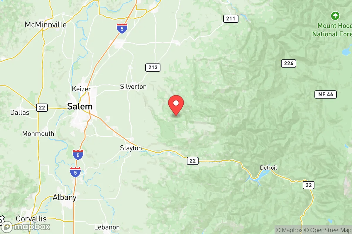
Marion County, Oregon, sits in a geographic sweet spot that balances access to critical resources with a buffer from the worst-case scenarios that keep preppers up at night. Its position in the Willamette Valley, roughly 40 miles south of Portland and 50 miles east of the Pacific Coast, offers a mix of agricultural self-sufficiency, defensible terrain, and distance from the most obvious fallout targets. For a conservative-leaning relocator thinking in terms of civic unrest, supply chain collapse, or mass casualty events, this county presents a strategic option worth a hard look—provided you understand both its strengths and its very real vulnerabilities.
Geographic position and natural advantages for long-term survival
Marion County’s geography is its primary asset. The county is anchored by the city of Salem, the state capital, but the real value lies in the surrounding rural areas—towns like Silverton, Mount Angel, and Stayton. These communities sit in the fertile Willamette Valley, flanked by the Cascade Range to the east and the Coast Range to the west. That valley floor is some of the most productive agricultural land in the Pacific Northwest, meaning local food production isn’t a hypothetical—it’s a daily reality. The county is a top producer of hazelnuts, berries, grass seed, and wine grapes, and small-scale farming is widespread. For a prepper, that translates to a robust local food network that won’t vanish when the trucks stop running. Water is equally abundant: the Willamette River runs through the county, and the Santiam River system feeds the eastern side. The Cascade foothills provide reliable snowmelt-fed creeks and springs, giving off-grid properties a realistic shot at independent water. The terrain itself offers defensibility—the eastern edge rises into forested hills and the western side has ridges that provide natural chokepoints. Unlike the flat, open ground of the Central Valley or the Texas plains, Marion County gives you options for concealment and retreat.
Risks, exposures, and proximity to fallout-relevant landmarks
No strategic assessment is honest without naming the downsides. Marion County’s biggest exposure is its proximity to Portland and the I-5 corridor. Portland is a major population center, a transportation hub, and a likely flashpoint for civil unrest—something the 2020 riots made painfully clear. In a mass casualty event or societal collapse, the I-5 corridor becomes a funnel for refugees, and Salem sits right on that highway. The county also contains the state capitol building and associated government infrastructure, which could become a target for political violence or a focal point for chaos. On the industrial side, the Port of Portland and the Portland International Airport are about 45 miles north—both are plausible targets for a coordinated attack or a dirty bomb scenario. Closer to home, the Willamette River runs through the county, and while it’s a water source, it also carries risk from upstream industrial spills or contamination. There are no major refineries or nuclear plants in Marion County itself, but the Trojan Nuclear Plant site (decommissioned but still holding spent fuel) is about 30 miles north in Rainier, Oregon. That’s close enough to be a concern if a terrorist event or earthquake compromised the storage. The Cascadia Subduction Zone earthquake is the elephant in the room—a major quake would devastate the I-5 corridor, trigger landslides in the foothills, and potentially cut off road access for days or weeks. The county’s location in a seismic zone means any long-term plan must account for structural hardening and multiple evacuation routes.
Practical resilience for a relocator: food, water, energy, and defensibility
For a single individual or a family looking to build a resilient homestead, Marion County offers a workable baseline. Food is the strongest category: the county has dozens of farmers’ markets, CSAs, and u-pick operations, and the growing season runs from April to October. You can realistically produce a significant portion of your own calories on a few acres, especially with staples like potatoes, beans, and squash. Water is less of a concern than in drier western states—annual rainfall averages 40-50 inches, and groundwater is accessible in most rural areas. That said, well drilling costs vary, and some areas near the Santiam River have higher mineral content. Energy is a mixed bag. The county is served by Portland General Electric and Salem Electric, both of which have decent reliability, but the grid is vulnerable to ice storms and earthquake damage. Solar is viable, but the Pacific Northwest’s cloudy winters mean you’ll need battery storage and a backup generator—wood heat is a practical alternative, and firewood is plentiful in the eastern timberlands. Defensibility depends on your exact location. Rural properties east of I-5, near Silver Falls State Park or the Santiam State Forest, offer natural cover and limited road access. The downside is that those same roads can become impassable in a winter storm or after a quake. The county’s population density is moderate—about 350,000 people total—but Salem itself is a city of 175,000, so you want to be at least 15-20 miles outside the urban core to avoid the worst of any refugee flow. The local gun culture is present but not as overt as in Idaho or Montana; Oregon’s Measure 114 (passed in 2022 but currently tied up in court) would restrict magazine capacity and require permits, so keep an eye on that if you’re planning to stockpile.
The overall strategic picture for Marion County is one of cautious optimism. It’s not a bug-out paradise like the Idaho panhandle or the Montana Rockies, but it offers a realistic middle ground for someone who wants to stay within driving distance of the West Coast’s economic hubs while building a self-sufficient lifestyle. The agricultural base, water availability, and varied terrain give it a solid foundation for long-term resilience. The risks—proximity to Portland, the I-5 corridor, earthquake danger, and potential fallout from the Trojan site—are real but manageable with proper planning. If you’re a conservative relocator looking for a place that balances opportunity with exposure, Marion County deserves a spot on your short list. Just don’t buy in Salem proper, and make sure your property has a well, a wood stove, and a good line of sight to the nearest ridgeline.
* Values derived from national, state, county, city and local statistics and may differ in a specific area. Last updated: 2026-05-22T20:19:50.000Z
Narrative content on this page is AI-generated and may contain mistakes. Verify any details that matter before acting on them.
ReloMaps may earn a commission from affiliate links at no extra cost to you.