Photo: Wikipedia
Strategic Assessment of Pawtucket, RI
Multiple tactical vulnerabilities. Population density, target proximity, or disaster risk are likely compounding. A retreat property and exit planning is required.
What does the Strategic Assessment tell us?
Our Strategic Assessment grades tactical survivability of an area. Major population centers, military targets, fallout zones, natural disasters, and border exposure all drive risk — lower exposure means a more defensible position in a crisis.
This is heavily inspired by Joel Skousen's Strategic Relocation book. Highly recommended you checkout the book ($)What does this tell us?
Our Strategic Assessment grades tactical survivability of an area. Major population centers, military targets, fallout zones, natural disasters, and border exposure all drive risk — lower exposure means a more defensible position in a crisis.
This is heavily inspired by Joel Skousen's Strategic Relocation book. Highly recommended you checkout the book ($)Strategic Pillars

Key Distances
Regional Safe Places
Below is our recommended "safe zones" in Rhode Island and the surrounding area based on our strategic heuristics. For most people, it's unrealistic to live in a “safe zone” full-time due to work, family or other personal reasons. They tend to be more rural. However, many of these areas are perfect for second homes and retreat properties that double as a vacation home or even a short-term rental.


Important Note: For informational purposes only. This does not mean nothing bad ever happens in the green zones. Please use common sense. This is based on public data and modeled with AI. We tried to take a conservative approach but mistakes happen. We update this regularly as new information becomes available.
Solar Generator Recommendations
Backup power matters more here than in safer locations. We've picked three solar generators across budgets and capacity tiers — start with the budget unit if you only need a few essentials, or step up if you want to run a fridge and HVAC for days at a time.

Jackery Portable Power Station Explorer 300
Budget OptionPower on the Go: Weighing only 11 lbs, it's convenient to set up and store with book-sized foldable solar panels

BLUETTI Portable Power Station AC180
Designed for both indoor and outdoor scenarios, AC180 is highly capable as it has a robost capacity and continuous output power.

EF ECOFLOW DELTA Pro Ultra Power Station
Upgraded PickEcoFlow DELTA Pro Ultra is a whole-home energy system designed to grow with your family. Integrated with the Smart Home Panel 2, it scales to meet your evolving energy needs — keeping your home powered, intelligent, and secure through every stage of life.
We earn a commission, at no additional cost to you.
Strategic Assessment Analysis
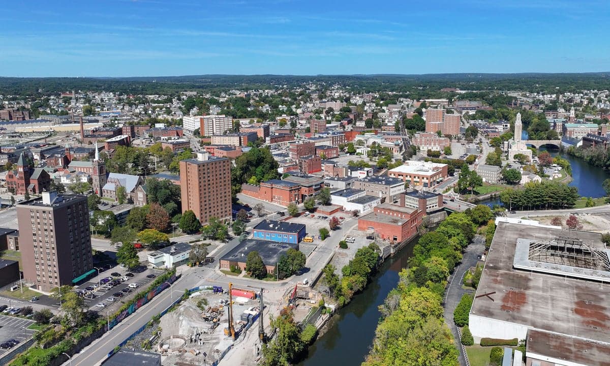
Pawtucket, Rhode Island, presents a complex strategic picture for the conservative prepper. Its location along the Blackstone River and its position as a dense, historic mill city offer some surprising resilience advantages, but these are heavily offset by its proximity to major urban centers and critical infrastructure that would become liabilities in a crisis. For a relocator prioritizing long-term survival and community cohesion over convenience, Pawtucket is a high-risk, moderate-reward proposition that demands a clear-eyed assessment of its trade-offs.
Geographic position and natural advantages for long-term survival
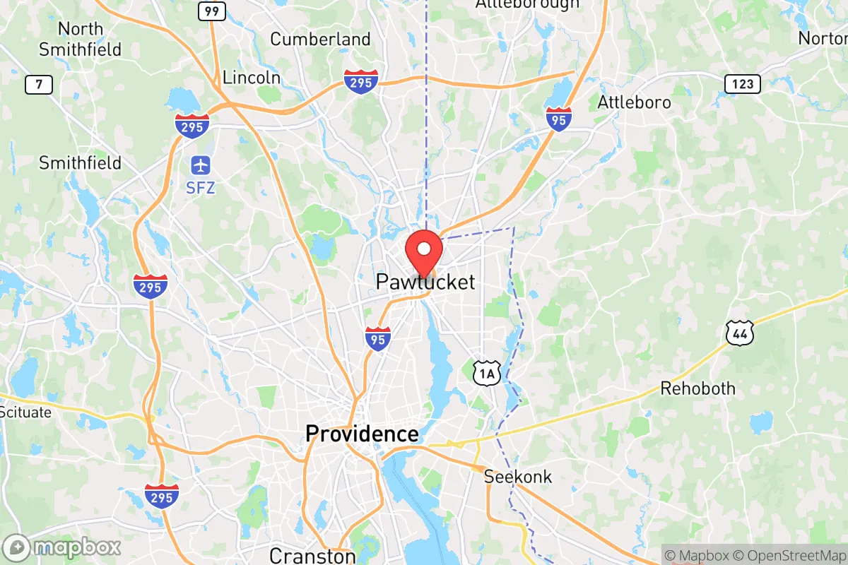
Pawtucket sits at the confluence of the Blackstone River and the Seekonk River, roughly 5 miles north of Providence and 40 miles southwest of Boston. This riverine network provides a reliable, if not pristine, freshwater source for filtration and small-scale agriculture. The city’s elevation ranges from about 30 to 150 feet above sea level, offering some natural drainage and reducing flood risk compared to coastal areas. The surrounding terrain is a mix of urban development and second-growth forest, with the Blackstone River Valley National Heritage Corridor providing pockets of green space like Slater Memorial Park and the Blackstone River Bikeway. These corridors could serve as rudimentary escape routes or foraging grounds in a grid-down scenario, though they are far from wilderness. The region’s temperate climate supports a growing season of roughly 150 days, suitable for cold-hardy crops like potatoes, kale, and root vegetables. However, the soil in much of the city is heavily disturbed from centuries of industrial use, requiring raised beds or imported topsoil for reliable yields. The proximity to the Atlantic Ocean (about 20 miles) offers potential for coastal foraging and fishing, but also exposes the area to nor’easters and hurricane storm surges, which could disrupt supply chains and power grids for weeks.
Risks, exposures, and proximity to fallout-relevant landmarks
The most significant strategic liability is Pawtucket’s location within the Boston-Washington corridor, a primary target for any large-scale conflict or terrorist event. The city lies within 15 miles of the Quonset Point Naval Air Station and the Port of Providence, both critical military and logistics hubs that would be high-value targets. Additionally, the nearby Pilgrim Nuclear Power Station (about 30 miles southeast in Plymouth, MA) and the Seabrook Station (about 50 miles north in New Hampshire) present a dual threat: a meltdown or sabotage could render large swaths of the region uninhabitable for decades. Pawtucket itself is home to several chemical storage facilities and industrial sites along the Blackstone River, including a former manufactured gas plant site that still contains coal tar residues. In a collapse scenario, these would become toxic hazards. The city’s dense, aging housing stock—much of it wood-frame triple-deckers—creates a severe fire risk in a grid-down situation, with narrow streets that would impede emergency response. The population density of roughly 8,000 people per square mile means that any civil unrest in Providence or Boston would quickly spill over, as Pawtucket is a primary commuter corridor via I-95 and Route 95. The city’s demographics are diverse but economically strained, with a median household income around $45,000 and a poverty rate near 20%, which could lead to resource competition in a prolonged crisis.
Practical resilience for a relocator: food, water, energy, and defensibility
For a relocator, Pawtucket’s practical resilience is mixed. Water access is a genuine asset: the Blackstone River flows year-round, and the city’s municipal water system draws from the Scituate Reservoir, about 15 miles west. However, the treatment plant is a single point of failure; a prepper would need a high-quality portable filter (e.g., Berkey or Sawyer) and knowledge of local tributaries. Food production is constrained by limited yard space—most homes have small lots or no yards—but community gardens exist at places like the Pawtucket Community Farm and the Blackstone Valley Community Garden. Rooftop gardening or hydroponics in a basement would be more viable. Energy independence is difficult due to the urban grid; solar panels on a south-facing roof could provide partial power, but tree cover and building shadows reduce efficiency. A propane generator with a secure fuel cache is more practical, but noise discipline would be a concern. Defensibility is the weakest link. The city’s street grid is a mix of narrow, winding roads and arterial highways, making it easy to get trapped but hard to secure a perimeter. A single-family home with a fenced yard in a quieter neighborhood like Oak Hill or Woodlawn offers better defensibility than a triple-decker in the downtown core. The nearest rural retreat areas are in northern Rhode Island (e.g., Burrillville, Glocester) or southern Massachusetts (e.g., Rehoboth, Seekonk), but these are 20-30 minutes by car—a distance that becomes a chokepoint if roads are blocked. The local police force is small (about 120 officers) and would be overwhelmed in a major event, so reliance on a neighborhood watch or mutual assistance group is essential.
The overall strategic picture for Pawtucket is one of calculated risk. It is not a destination for the lone wolf prepper seeking isolation, but it could work for a disciplined group that values the river’s water, the region’s agricultural potential, and the ability to blend into an urban environment during a slow-burn collapse. The proximity to Providence and Boston is a double-edged sword: it provides access to medical facilities and supply networks in the short term, but those same cities become death traps in a fast-moving crisis. For a conservative relocator, the key is to treat Pawtucket as a staging ground—a place to build skills, cache supplies, and network with like-minded individuals—while maintaining a bug-out plan to more defensible rural property within a 50-mile radius. The city’s industrial history has left it with a resilient, working-class character that values self-reliance, but the infrastructure and demographics demand constant vigilance. If you can secure a property with a well, a garden, and a defensible layout, and you are willing to invest in water filtration, solar backup, and community relationships, Pawtucket offers a foothold in a region that will be contested. If you are looking for a quiet, low-profile retreat, look further north or west. This is a place for the prepared, not the passive.
* Values derived from national, state, county, city and local statistics and may differ in a specific area. Last updated: 2026-04-20T17:55:19.000Z
Narrative content on this page is AI-generated and may contain mistakes. Verify any details that matter before acting on them.
ReloMaps may earn a commission from affiliate links at no extra cost to you.