
Photo: Wikipedia
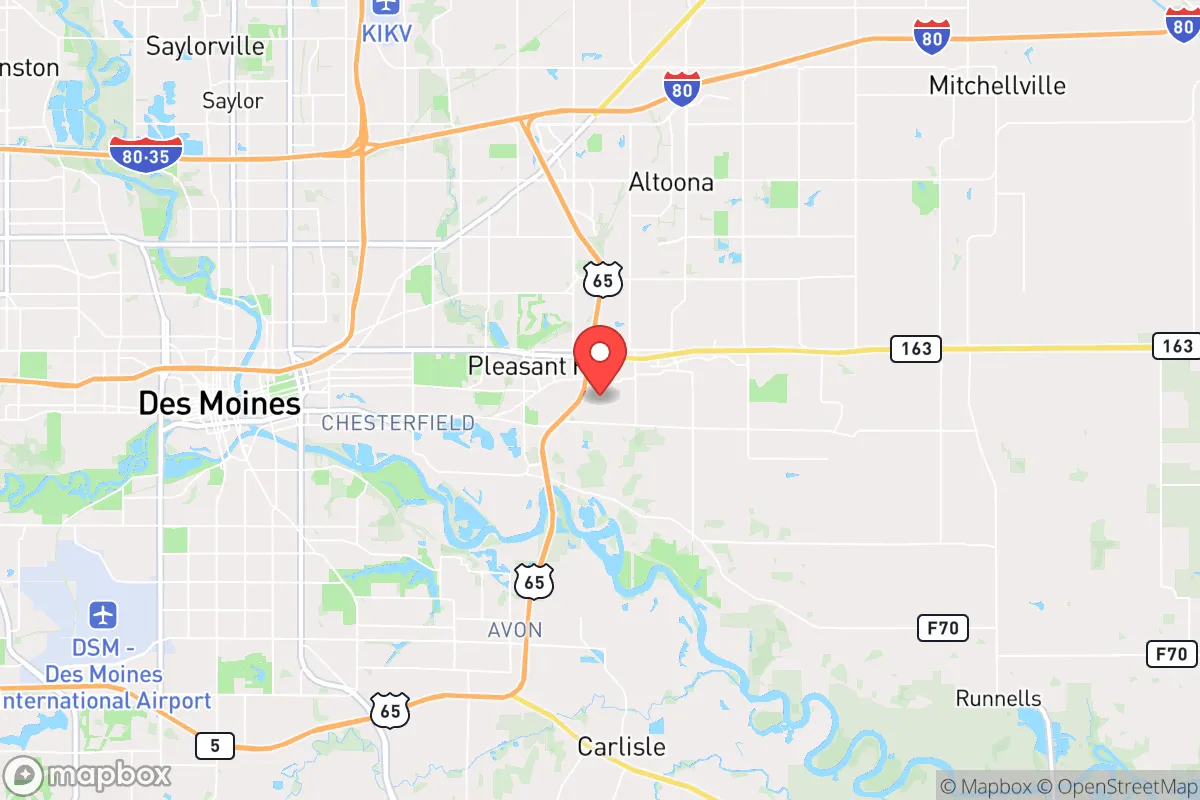
Strategic Assessment of Pleasant Hill, IA
Meaningful friction. Expect exposure to either population pressure, blast zones, or natural disaster risk. Consider buying a retreat property.
What does the Strategic Assessment tell us?
Our Strategic Assessment grades tactical survivability of an area. Major population centers, military targets, fallout zones, natural disasters, and border exposure all drive risk — lower exposure means a more defensible position in a crisis.
This is heavily inspired by Joel Skousen's Strategic Relocation book. Highly recommended you checkout the book ($)What does this tell us?
Our Strategic Assessment grades tactical survivability of an area. Major population centers, military targets, fallout zones, natural disasters, and border exposure all drive risk — lower exposure means a more defensible position in a crisis.
This is heavily inspired by Joel Skousen's Strategic Relocation book. Highly recommended you checkout the book ($)Strategic Pillars

Key Distances
Regional Safe Places
Below is our recommended "safe zones" in Iowa and the surrounding area based on our strategic heuristics. For most people, it's unrealistic to live in a “safe zone” full-time due to work, family or other personal reasons. They tend to be more rural. However, many of these areas are perfect for second homes and retreat properties that double as a vacation home or even a short-term rental.


Important Note: For informational purposes only. This does not mean nothing bad ever happens in the green zones. Please use common sense. This is based on public data and modeled with AI. We tried to take a conservative approach but mistakes happen. We update this regularly as new information becomes available.
Solar Generator Recommendations
Backup power matters more here than in safer locations. We've picked three solar generators across budgets and capacity tiers — start with the budget unit if you only need a few essentials, or step up if you want to run a fridge and HVAC for days at a time.

Jackery Portable Power Station Explorer 300
Budget OptionPower on the Go: Weighing only 11 lbs, it's convenient to set up and store with book-sized foldable solar panels

BLUETTI Portable Power Station AC180
Designed for both indoor and outdoor scenarios, AC180 is highly capable as it has a robost capacity and continuous output power.

EF ECOFLOW DELTA Pro Ultra Power Station
Upgraded PickEcoFlow DELTA Pro Ultra is a whole-home energy system designed to grow with your family. Integrated with the Smart Home Panel 2, it scales to meet your evolving energy needs — keeping your home powered, intelligent, and secure through every stage of life.
We earn a commission, at no additional cost to you.
Strategic Assessment Analysis
Pleasant Hill, Iowa, offers a surprisingly resilient strategic position for those prioritizing long-term stability and preparedness, balancing proximity to Des Moines' resources with a buffer from its densest vulnerabilities. Located just southeast of the capital, this suburb of roughly 10,000 residents sits on higher ground above the Des Moines River, providing natural drainage advantages and a degree of separation from flood-prone zones. For the prepper or survivalist, Pleasant Hill’s key strength lies in its access to major transportation corridors—Interstate 80 and U.S. Highway 65—without being choked by the congestion and surveillance density of downtown Des Moines, making it a viable hub for supply runs or evacuation if needed.
Geographic position and natural advantages for long-term stability
Pleasant Hill occupies a strategic ridge line in Polk County, with elevations around 850 feet that offer both visibility and natural drainage—critical for avoiding the flash flooding that can plague lower-lying areas along the Raccoon and Des Moines Rivers. The surrounding terrain is a mix of agricultural flatlands and rolling hills, providing ample space for private gardens, rainwater catchment, and off-grid energy setups like solar panels, which are increasingly viable given Iowa’s moderate sun exposure. The area’s continental climate means cold winters and hot summers, but the lack of major seismic activity, hurricane paths, or wildfire corridors reduces the likelihood of natural disasters that could trigger mass displacement. For a relocator, this means the land itself is a stable foundation—no coastal erosion, no fault lines, and a growing season long enough to sustain a serious food production effort.
Risks, exposures, and proximity to fallout-relevant landmarks
The most significant vulnerability for Pleasant Hill is its proximity to Des Moines, roughly 10 miles northwest, which is a regional hub for government, finance, and healthcare—and therefore a potential target for civil unrest, cyberattacks, or infrastructure failures. The Des Moines International Airport, the Iowa State Capitol, and major data centers along the I-80/35 corridor are all within a 20-minute drive, meaning any large-scale event in the capital could ripple into Pleasant Hill via road closures, supply chain disruptions, or population displacement. Additionally, the area sits within 100 miles of the Neal Smith National Wildlife Refuge and the Iowa Army Ammunition Plant in Middletown, which, while not a nuclear target, could be a secondary concern for those tracking industrial hazards. The presence of large-scale livestock operations and concentrated animal feeding operations (CAFOs) in surrounding counties also introduces a risk of localized disease outbreaks or water contamination, particularly if grid power fails and waste management systems are compromised. For the conservative prepper, the calculus is clear: Pleasant Hill offers a buffer, but not a fortress—you’re close enough to benefit from Des Moines’ resources (hospitals, hardware stores, fuel depots) but close enough to be affected by its chaos.
Practical resilience for a relocator: food, water, energy, and defensibility
For those serious about self-sufficiency, Pleasant Hill’s residential zoning and lot sizes—typically quarter-acre to half-acre in established neighborhoods—allow for meaningful food production without drawing attention. Backyard chicken coops, raised garden beds, and rainwater barrels are feasible and common among locals, and the city’s code enforcement is generally lenient compared to stricter suburbs like West Des Moines. Water access is a mixed bag: the city draws from the Des Moines Water Works, which treats surface water from the Raccoon and Des Moines Rivers, but a private well is a viable option for those purchasing property on the outskirts, with groundwater depths averaging 50-100 feet. Energy resilience is improving, with several local installers offering solar-plus-battery systems, and the area’s grid is part of the Midcontinent Independent System Operator (MISO) region, which has a mixed reliability record during extreme weather—winter storms in 2021 and 2024 exposed vulnerabilities that a prepared household can mitigate with a generator and fuel storage. Defensibility is moderate: Pleasant Hill is a suburban grid of cul-de-sacs and arterial roads, not a natural fortress, but the lack of dense multi-family housing and the presence of several parks and green spaces (like Pleasant Hill Park and the Easter Lake area) provide options for retreat or rally points. The local police department is small but responsive, and the community’s demographic profile—predominantly families and retirees—suggests lower crime rates and a higher likelihood of neighborhood mutual aid compared to urban cores.
The overall strategic picture for Pleasant Hill is one of calculated compromise: it offers a solid base for a prepared individual or family who wants to stay within striking distance of Des Moines’ economic and medical infrastructure while maintaining a defensible, self-sufficient lifestyle. The risks are real—proximity to a major city, reliance on a centralized water system, and exposure to agricultural industrial hazards—but they are manageable with proper planning, such as drilling a well, installing off-grid power, and building a trusted local network. For the conservative relocator who views current national trends with concern, Pleasant Hill represents a middle path: not a remote bunker in the hills, but a suburban stronghold where you can live a normal life while quietly stacking supplies, skills, and relationships. The key is to treat it as a launch point, not a final destination—a place to build resilience while keeping an eye on the horizon, ready to adapt if the world shifts further off course.
* Values derived from national, state, county, city and local statistics and may differ in a specific area. Last updated: 2026-04-30T08:10:08.000Z
Narrative content on this page is AI-generated and may contain mistakes. Verify any details that matter before acting on them.
ReloMaps may earn a commission from affiliate links at no extra cost to you.